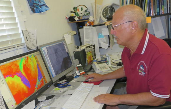
(Above: Mitch Roffer, founder of Roffers Ocean Fishing Forecasting Service Inc. in West Melbourne, examines sea and weather conditions off Florida’s east coast in the Atlantic Ocean.)
After an offshore angler buys $50 worth of bait, takes on hundreds dollars worth of fuel and leaves the dock, a simple but vexing conundrum must be confronted.
What course should the boat’s owner or captain take across a vast, lonely and seemingly empty ocean? In other words, where are the darn fish, the big ones worth bragging about?
Providing answers, complete with a color map, is how Mitch Roffer has made a living since 1987, when he founded Roffer’s Ocean Fishing Forecasting Service Inc., or ROFFS™.
After earning a doctorate in oceanography from the University of Miami, he set up shop in South Florida and then moved to Central Florida eight years ago.
“We deal with people from the average, everyday fisherman to the big, tournament fisherman, as well as commercial fisherman,” said Roffer, 65.
“The key for anyone is that when you leave the dock, you have to decide which way to go and at the east coast of Florida, you can go left, right or straight and sooner or later one will find the Gulf Stream.”
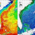
ROFFS™ uses satellite images to watch that big, warm current, which surges north along Florida and the East Coast to cross the Atlantic Ocean. The path of the Gulf Stream wiggles like a snake and its edges are a chaos of offshoots, loops and eddies.
At his headquarters in West Melbourne, Roffer clicked a command on his computer to display a rapid fire of the day’s satellite images depicting Stream activity.
Doing so reveals an animation of Gulf Stream wiggles and quirks, and highlights for Roffer where pushes and pulls in the ocean likely would be concentrating phytoplankton, zooplankton, bait fish and, probably, tuna, dolphin, wahoo and marlin.
“It’s a little ecosystem,” Roffer said.
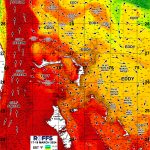
ROFFS™ points out those ecosystems on maps that are emailed to clients during the afternoon prior to when they throw off their dock lines and head to sea.
He and four other analysts develop forecasts that are specific to client trips and cost $50 to $65, more or less, depending on the quantity purchased. ROFFS™ delivers 500 to 700 forecasts weekly.
Along with maps, clients get a written discussion on where to go and what to look for. The narrative is in angler lingo.
A forecast in January last year reported that “conditions offshore of Fort Pierce suggest your better chances for fishing action with tuna, dolphin, wahoo and sailfish will occur along the inshore edges of the blended blue to blue 75.3 F water that continues to get pulled northward and inshore over the 20 fathom ledge where conditions have remained favorable for the past two days.”
Fishing forecasts are available from a variety of sources, including marina rumors, captains comparing notes and online. There are few companies like ROFFS™.
The National Oceanic and Atmospheric Administration provides satellite data and Rutgers University offers sea-surface temperatures. Their information is free but the user must figure out what it means.
A North Carolina-based service at fryingpantower.com provides free data that clients can use to develop forecasts or they can buy forecasts. Owner Dave Tilley said his service is similar to ROFFS™ but doesn’t cater as much to high-end tournament contestants.
“He’s the godfather of this business,” Tilley said. “Nothing but respect for him.”
Most of ROFFS™ clients have boats that range in cost from a few hundred thousand dollars to many millions of dollars.
Terry Winn, past president of Central Florida Offshore Anglers, said a $50 investment in a forecast can save more than that in fuel.
He said an offshore boat may burn a gallon of fuel for every mile traveled and an angler trolling waters along the far side of the Gulf Stream may put in 250 miles in a day.
“With the price of fuel, you need to know where you are going,” Winn said.
ROFFS™ specializes in East Coast and Gulf of Mexico waters and focuses on fishing elsewhere in the world if there’s enough client demand.
He has stayed active in marine research, working with federal agencies, and has broadened his business to include forecasting conditions for large and specialized vessels, such as oil rigs.
Fishing is the mainstay and he urges clients to go easy on the little ecosystems.
“We tell people the purpose of the service is for people to have a good time out there,” Roffer said. “But conserve the resource. If you catch all the fish today, you aren’t going to have fun tomorrow or next year.”
Re-posted from Orlando Sentinel Sunday August 24, 2014 – Please click HERE if you want to read original article.