Article Courtesy: floridatoday.com – Ted Lund | Originally Published: April 11, 2015 | Please click here for original article.
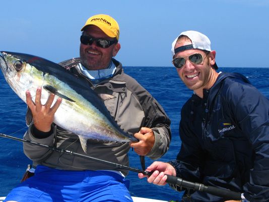
Above: Anglers can cutout the guesswork when looking for pelagic species, like this blackfin tuna, using ocean forecasting services like Melbourne-based ROFFS™. (Photo: Ted Lund/FOR FLORIDA TODAY)
It’s a typical morning in the West Melbourne offices of Roffs Ocean Forecasting (roffs.com), and Mitch Roffer, Ph.D., is fresh out of his kayak from exploring the waters near his coastal home just north of Sebastian Inlet.
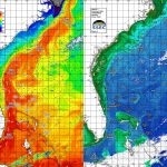
Roffer and his team are going over satellite imagery from around the world, producing subscription-based analysis helping pinpoint likely areas to find bait, game and food fish for recreational anglers and commercial fishermen from Maine to the Bahamas and throughout the Gulf of Mexico and Caribbean.
“We download the satellite every morning, and we have to re-navigate and re-calibrate the imagery,” Roffer says. “We do that to make sure the images fit GPS grids to pinpoint locations, but also to make sure that water temperatures are right. If we don’t, temperatures could be off by as much as one to three degrees.”
And that — as die-hard fishermen know — can be the difference between catching and not.
Unlike many other processes in our daily lives that have become rote thanks to automation, Roffer and his staff perform the initial work manually as they have most mornings since 1989.
“The automated methods just don’t work as well,” Roffer says. “In order to give the most accurate and reliable analysis available, it’s done by us every morning.”
That’s when the real work begins.
Roffer and his team draw on a number of disciplines and sources to analyze ocean currents, water temperature, color, clarity and chlorophyll levels, as well as plankton and bait concentrations. Then they take into account the feeding and temperature preferences of targeted species. Roffer’s data sets come from state-of-the-science satellite imagery, as well as in-the-field instruments like ocean buoys, gliders (autonomous underwater vehicles) and weather stations.
He and his staff then parse the data with their voluminous oceanographic knowledge of popular bait and game fish species, giving fishermen the upper hand. Starting at $65 per analysis, Roffer’s personalized services have done much to eliminate guesswork while searching for fish in a time of all-time-high fuel prices.
“Typically, we get a call from somebody that needs an analysis for fishing tomorrow for a specific area, so we’ll take what we have and put it in a movie loop to start watching the flow,” Roffer says. “We see how the Gulf Stream is moving, how other water masses — maybe a color band or a temperature break — are moving.”
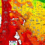
Once that information is taken into account, Roffer and his team superimpose the imagery over local benthic terrain and begin crafting an in-depth written analysis of what they’ve found, highlighting favorable conditions and how long those conditions have been observed in a particular area.
“The longer we observe conditions in a given area, the better chance you have of finding fish,” Roffer says. “The first day you start seeing scattered weed, then after several days the Sargasso concentrates, bringing baitfish, then dolphin, wahoo, tuna and other pelagics. Even if conditions change, the fish are orienting over significant bottom structure, and they’ll remain for as long as 24 hours.”
With all of that information combined into a color PDF, Roffer can then directly email the product to clients with specific waypoints indicating likely areas to target.
Roffer’s analysis have become incredibly popular with anglers since he first incorporated the business in 1989. Last year alone, his clientele amassed 403 wins in 87 different fishing tournaments, including the North and South Carolina Governor’s Cup tournaments, the Miami Billfish Tournament and the prestigious Custom Boat Shoot Out in the Bahamas. His forecasts also helped set the new Texas State blue marlin record.
But how does one get started in the ocean forecasting business?
“I had some captains that helped me out during my dissertation (at the University of Miami’s Rosenstiel School of Marine and Atmospheric Science) by letting me ride along and take samples,” Roffer says. “Then, after getting my degree, I was waiting around for an academic job. They said they needed help finding fish and I felt obligated.”
His skills produced, but soon the requests were overtaking his academic work.
“Finally I had to tell them I either need to hire somebody to do this work or do my research,” Roffer says. “I expected them to say no, but instead, they asked ‘How much?’ ”
Roffer started providing his services through the University of Miami while completing post-doctoral work; fees were donated to his research. Soon, though, Roffer decided to take his work off campus.
The first five years were tough; the company nearly went out of business.
“I had a decision to make, whether to raise prices or pull the plug,” Roffer says. “I doubled the price and the business took off. It was like we weren’t charging enough for the information we were providing. We had to move the business out of our home and into a Miami warehouse.”
In the early 2000s, Roffer and his wife decided they didn’t want to retire in Miami. They started looking around. They didn’t like the Keys or Southwest Florida. One was too much fun; the other too far from the fishing they loved. Then, while exploring the Space Coast, they fell in love driving over the bridge at Sebastian Inlet. Roffer bought property north of the inlet, and a mixed-use building in West Melbourne. He set up shop, living in the building and commuting to Miami on the weekends. Then, the 2004 hurricane season forced their hand.
“Construction prices were going out of control, so we decided to go ahead and build a home and make the move,” Roffer says.
Roffer’s services aren’t just for blue-water fishermen. In fact, he has a tip for Space Coast cobia anglers.
“If somebody were asking me where to look right now, I would say between Port Canaveral and Ponce Inlet,” Roffer says.
In the interest of continuing on-going research, Roffer says he’ll always entertain offers to get out on the water.
“Anybody ever wants to take me fishing,” Roffer says. “I’m all ears.”