ROFFER’S OCEAN FISHING FORECASTING SERVICE, INC.
TOLL FREE 800.677.7633 & (321) 723-5759 // 24 HR FAX (321) 723-6134 // fish7@ROFFS.COM
ROFFS™ FISHERIES OCEANOGRAPHIC ANALYSIS
FOR EAST COAST OF FLORIDA TO GEORGIA (LAT./LONG.)
UPDATED ON TUES. 28 JULY 2015
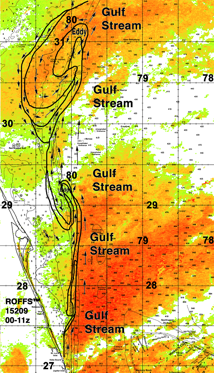
We providing this oceanographic analysis showing the outline of the Gulf Stream from the Jupiter area to Georgia to aid in the lost at sea search for Perry Cohen and Austin Stephanos. This analysis is based on watching real-time infrared and ocean color satellite imagery (NOAA, NASA, European Space Agency), not models that are often dependent on out of date and lower resolution altimeter data. We conduct a sequential image analysis, i.e., looking at one image after another to follow the different water masses and their boundaries. We use the last derived image, sometimes a combination of several images, to provide the background image. The water mass boundaries are traced manually after carefully judging the validity of each boundary. Clouds and high uneven atmospheric interfere with the observations and appear as white areas. Arrows on the analysis indicate direction not speed. With more ocean observing equipment such as HF radar and fixed ocean buoys with current meters, one would be able to get both current speed and direction. The outlined water mass boundaries are provided as they are convergence zones and hopefully will pull the floating boys to these boundaries which would provide more distinct targets for the search and rescue efforts. These water mass boundaries are strong convergence zones and could easily pull the boys and their cooler into these zones. There are too many scenarios to consider on where the likely position of the teens are especially since we do not know exactly where they entered the water Friday. We are assuming that they fell into water near the western boundary of the Gulf Stream off Jupiter for this analysis.
Of note today is the counter-clockwise eddy east of Jacksonville, FL centered near 79°50-55’W & 31°05-10’N. This continues to pull some of the Gulf Stream water 30 miles westward and southwestward. It is possible that Austin and Perry are being pushed along with this water. This eddy will continue moving northeastward toward Savannah, GA and Charleston, SC over the next few days. It is possible that Perry and Austin are circulating around this eddy. While we know from the NOAA buoy that the winds from Cape Canaveral have been from the southwest and south, but unfortunately there are no NOAA weather buoys off Jacksonville – St. Augustine anymore (retired to save money) to provide wind information. These wind measurements are critical for understanding how the winds will affect the drift of anything in the water.
If they are not in this eddy system off Jacksonville, FL they could be along the western boundary of the Gulf Stream between 29°30’N and 30°30’N. Presently this boundary is being pushed westward by another Gulf Stream meander and smaller eddy centered near 80°15’W & 29°15’N northeast of Cape Canaveral.
Again we are hopeful that these analyses will help people direct their search efforts to areas where there are increased chances for Austin and Perry to be found alive.
Please click here if you would like to download the full analysis as a PDF.