ROFFER’S OCEAN FISHING FORECASTING SERVICE, INC.
TOLL FREE 800.677.7633 & (321) 723-5759 // 24 HR FAX (321) 723-6134 // fish7@ROFFS.COM
ROFFS™ FISHERIES OCEANOGRAPHIC ANALYSIS
FOR NORTH FLORIDA TO SOUTH CAROLINA (LAT./LONG.)
UPDATED ON TUES. 29 JULY 2015
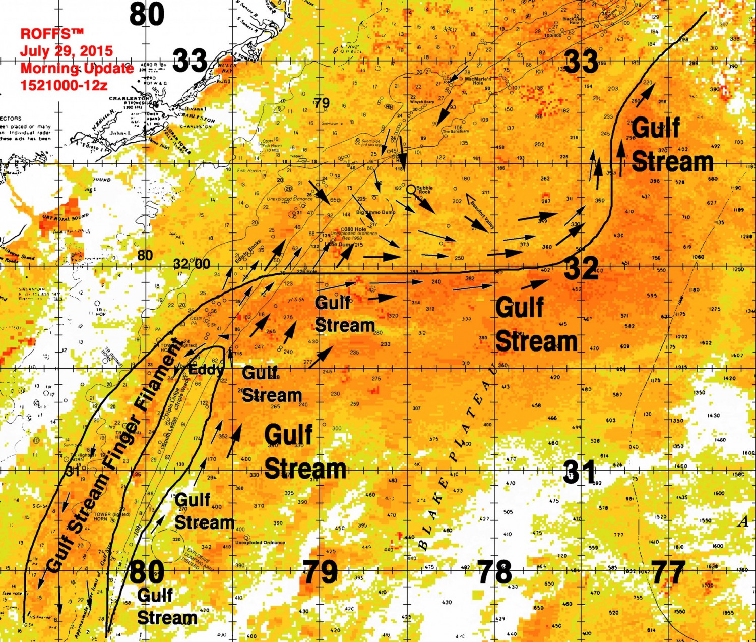
Again we providing this oceanographic analysis showing the outline of the Gulf Stream to aid in the lost at sea search for Perry Cohen and Austin Stephanos. This analysis is based on watching real-time infrared and ocean color satellite imagery (NOAA, NASA, European Space Agency), not models that are often dependent on out of date and lower resolution altimeter data. We conduct a sequential image analysis, i.e., looking at one image after another to follow the different water masses and their boundaries. We use the last derived image, sometimes a combination of several images, to provide the background image. The water mass boundaries are traced manually after carefully judging the validity of each boundary. Clouds and high uneven atmospheric interfere with the observations and appear as white areas. Arrows on the analysis indicate direction not speed. With more ocean observing equipment such as HF radar (extending from the coast to past the Gulf Stream) and fixed ocean buoys with current meters, one would be able to get both current speed and direction. The outlined water mass boundaries are provided as they are convergence zones and hopefully will pull the floating boys to these boundaries which would provide more distinct targets for the search and rescue efforts. These water mass boundaries are strong convergence zones and could easily pull the boys and their cooler into these zones. There are too many scenarios to consider on where the likely position of the teens are especially since we do not know exactly where they entered the water Friday. We are assuming that they fell into water near the western boundary of the Gulf Stream off Jupiter and have remained in the western boundary of the Gulf Stream and filaments for this analysis.
Today’s Update:
While we think that there is a good chance that the boys are located in the filament of blue Gulf Stream water east of Jacksonville west of 80°00W Longitude, there is a good chance that Austin and Perry are circulating around the counter-clockwise eddy centered near 79°25-45’W & 31°30’N. This eddy is moving in a north-northeastern direction and is expected to push the northern boundary of the Gulf Stream northward until it is offshore of Charleston, SC and then move east-northeastward. It remains to be seen how far north the eddy will move until it turns eastward. But our best estimate is that it will turn eastward near 78°45W- 79°00W & 32°15-30’N. Note that the Gulf Stream is presently directed eastward along 32°N latitude. But the eddy will push this boundary northward. Also note that the present flow of the waters offshore of Charleston is south-southeastward and north of Charleston the flow is in a southwestward direction. This is the usual flow in this area.
Again we are hopeful that these analyses will help people direct their search efforts to areas where there are increased chances for Austin and Perry to be found alive.
Please click here if you would like to download the full analysis as a PDF.