ROFFER’S OCEAN FISHING FORECASTING SERVICE, INC.
TOLL FREE 800.677.7633 & (321) 723-5759 // 24 HR FAX (321) 723-6134 // fish7@ROFFS.COM
ROFFS™ FISHERIES OCEANOGRAPHIC ANALYSIS
FOR NORTH FLORIDA TO SOUTH CAROLINA (LAT./LONG.)
UPDATED ON FRI. 31 JULY 2015
Rationale:
We are providing this oceanographic analysis showing the outline of the Gulf Stream to aid in the lost at sea search for Perry Cohen and Austin Stephanos. This analysis is based on watching real-time infrared and ocean color satellite imagery (NOAA, NASA, European Space Agency), not models that are often dependent on time averaged and lower resolution altimeter data. We conduct a sequential image analysis, i.e., looking at one image after another to follow the different water masses and their boundaries. We use the last derived image, sometimes a combination of several images, to provide the background image. The water mass boundaries are traced manually after carefully judging the validity of each boundary. Clouds and high uneven atmospheric interfere with the observations and appear as white areas. Arrows on the analysis indicate direction not speed. With more ocean observing equipment such as HF radar (extending from the coast to past the Gulf Stream) and fixed ocean buoys with current meters, one would be able to get both current speed and direction. The outlined water mass boundaries are provided as they are convergence zones and hopefully will pull the floating boys to these boundaries which would provide more distinct targets for the search and rescue efforts. These water mass boundaries are strong convergence zones and could easily pull the boys and their cooler into these zones. There are too many scenarios to consider on where the likely position of the teens are especially since we do not know exactly where they entered the water Friday. We are assuming that they fell into water near the western boundary of the Gulf Stream off Jupiter and have remained in the western boundary of the Gulf Stream and filaments for this analysis.
Today’s Update:
The eddy that we have been following southeast of Charleston, SC is centered near 79°10’W & 31°55’N. It continues to move northeastward. There may be a smaller eddy (2-3 mile diameter) along the western boundary of the Gulf Stream by the eddy, but the clouds have prevented us from confirming this. It is likely to coalesce with the larger eddy and create more turbulence in the flow. Note that the elongated finger-filament of Gulf Stream now extends from 79°00’W & 32°10’N all the way back (southwest) to St. Augustine. The southern end is near 80°45’W & 31°50’N. The flow of the blended Gulf Stream water in the filament is southwestward to St. Augustine and a blend of this water with the coastal waters extend to Flagler Beach. Off Daytona Beach the water is moving northeastward. The boys could be in this elongated filament as they could still be rotating around the eddy. Note that there are two relatively smaller (2-3 mile diameter) eddy features moving northward between Daytona Beach and Jacksonville Beach and a smaller one yet east of Fernandina Beach, FL centered near 79°30’W & 31°20’N. This northernmost small eddy is likely to affect the shape and circulation of the eddy that the boys could be in. We do not think that the boys will be along the western boundary of the Gulf Stream south of 31°00’N. We anticipate that the eddy southeast of Charleston (centered near 79°10’W & 31°55’N) will continue to move in a northeast direction. However, we are uncertain if it will reach the Georgetown Hole fishing area (centered near 78°35’W & 32°32N), or turn more eastward like many eddy features do. Note that the flow of the water east of Charleston, SC still is eastward.
Bottom Line:
The search area continues to increase considering the various movements of the water masses to carry the boys. We are now uncertain how much our analyses are assisting the search although we continue to receive calls asking for direction from pilots and boaters. Our best estimate is that the search should continue around the eddy area, the area where the eddy is traveling, as well as, the filament of blue water that extends southwestward to Jacksonville – St. Augustine. If your reach is only off Flagler Beach, FL it is worth a look as well. IF the boys were not caught in the eddy circulation then they would be far east of Charleston, SC headed northward toward Cape Hatteras.
Again we are hopeful that these analyses will help people direct their search efforts to areas where there are increased chances for Austin and Perry to be found alive.
Please click here if you would like to download the full analysis as a PDF.
[responsive]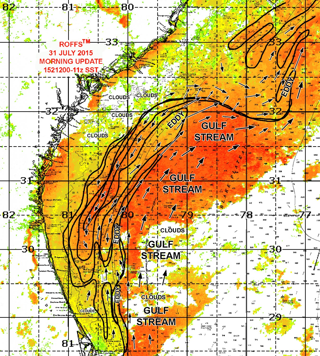 [/responsive]