Please click here to download full article as a PDF.
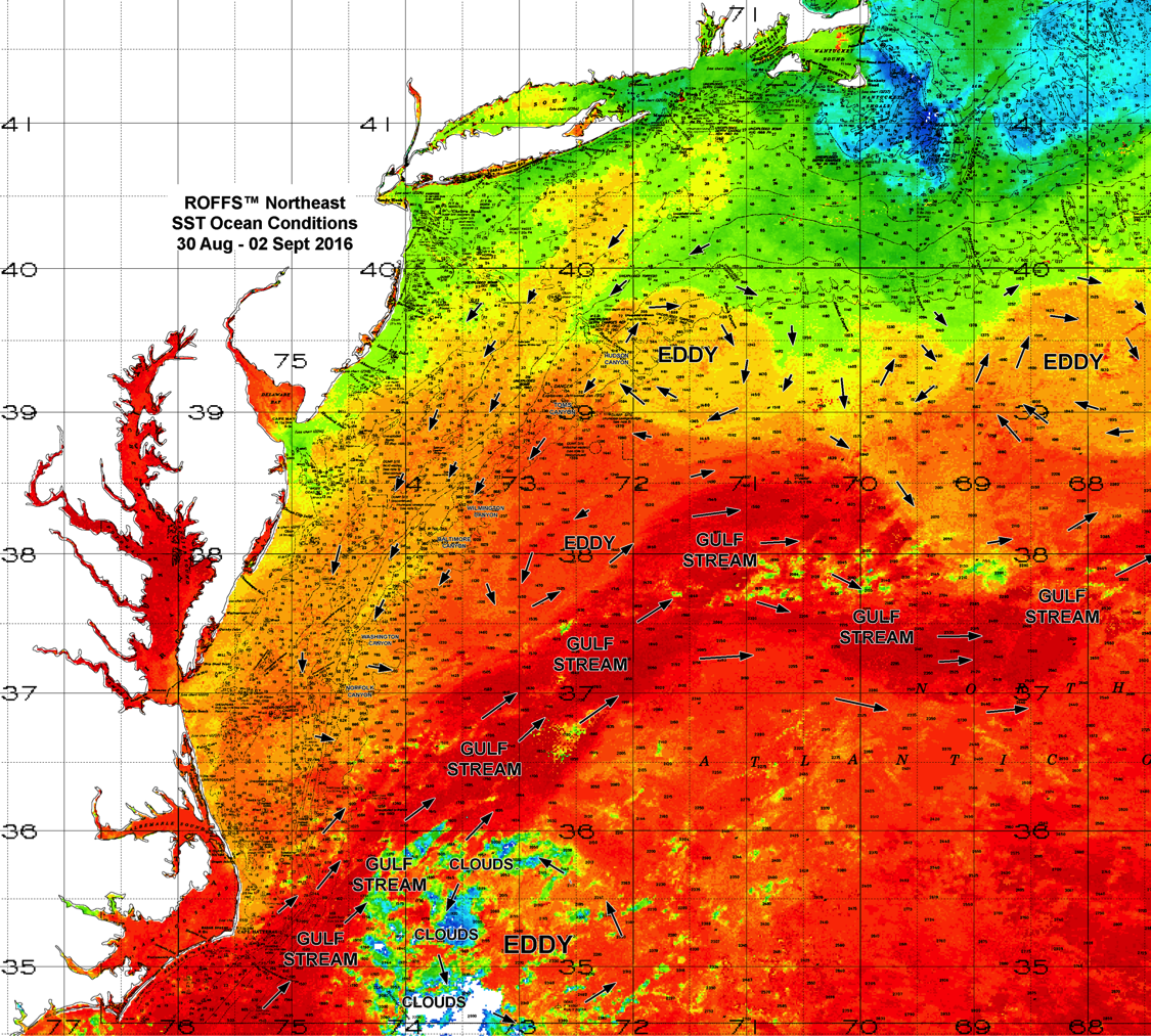
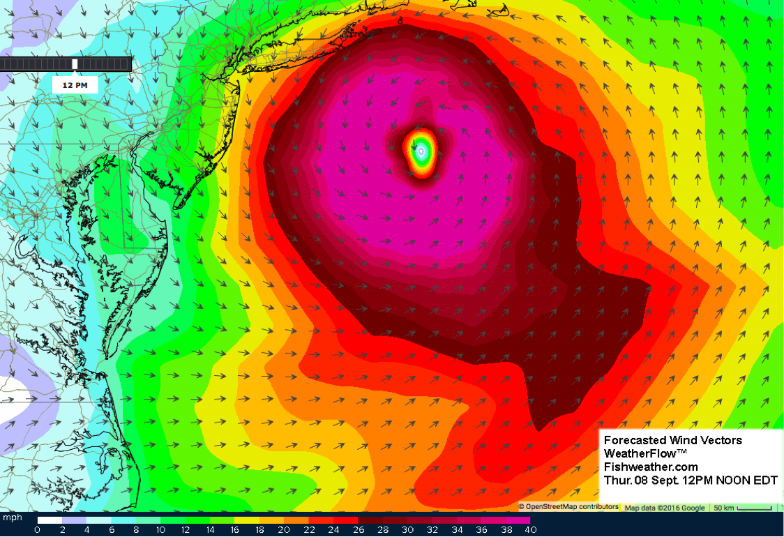
With the anticipation of the arrival of the Tropical Storm Hermine toward the Northeast United States we wanted to give an overview of what this large storm will do to the offshore waters and oceanic conditions of the Mid-Atlantic. This storm is forecasted to arrive on Saturday then sit offshore south of Long Island to Massachusetts and east of Maryland, Delaware for the better part of the next week. It is important to first understand that this report is what is most likely to happen if the forecast is correct, as the ocean responds differently depending on the time scales of the wind and wind direction and speed. We will provide several images of the forecasted offshore wind vectors based on the weather forecast from WeatherFlow™ and Fishweather.com to give you a visual of what the winds are likely going to do. First of all, for reference we want to provide you with an overall view of the ocean conditions this week before the storm arrives.
The main concentration will be about what the sustained high winds will do to the offshore waters and surface water flow as this storm sets up offshore next week. The bad news is the original forecast was for this storm to be offshore in this area through Monday (Labor Day) and maybe Tuesday then move out of this area. However, the most recent forecast is predicting the storm will be offshore in this area sitting through Wednesday and even possibly Thursday before moving out. This will intensify the effects of the sustained offshore winds effecting the ocean conditions from offshore of North Carolina and Virginia all the way to offshore of New York to Massachusetts.
Bottom line is we can expect these winds to significantly mix up and destabilize the water column especially effecting the inshore waters (inshore of 50-100 fathoms) as the water column will turn over and be well mixed. With the intense wind mixing you can expect the SST (Sea Surface Temperature) to drop at least 2.0°F to 4.0°F degrees in most offshore places and maybe even lower inshore near the coast. Again, the longer the storm sits offshore in a similar location the more mixing and cooling will occur deeper in the offshore water columns. The good news is once this storm vacates the area, the late summer atmospheric temperatures should return the majority of the offshore SST to within 1.0°F to 2.0°F of the pre-storm conditions within a few days. Then the water will take two to four days to calm down and start to stabilize again. The wind mixing will also “green up” the surface layer of the water offshore. When the water column mixes it bring nutrients from below the surface to near the surface and the phytoplankton and zooplankton thrive and multiply making the water greener overall. So the bluer to blue-green waters now will likely change briefly to green and blue-green respectively for a few days until the winds settle down. With all this in mind, now let us look into more detail at what the storm is forecasted to do and try to step through what the winds will do to the near surface water flow as time progresses.
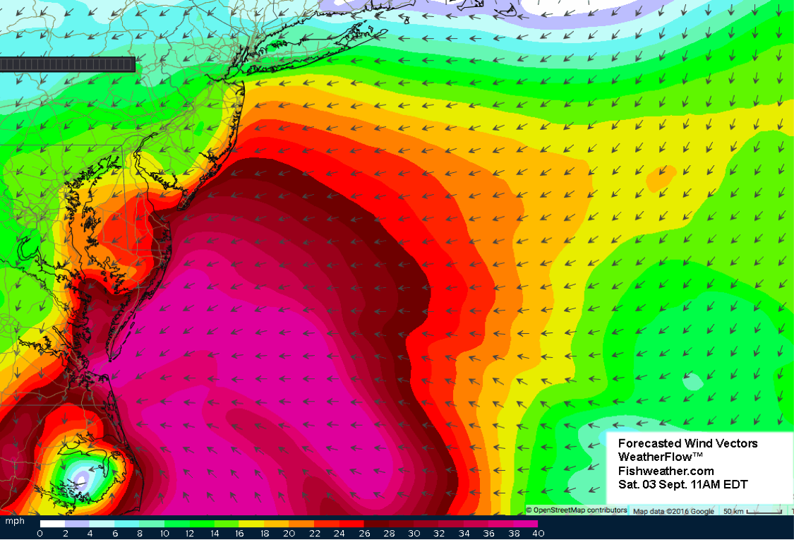
As this storm approaches, the forecast for the conditions Saturday morning is for Hermine to be centered just east of Cape Hatteras. Originally the winds will be rapidly intensifying and blowing from southeast to northwest at 30-40 mph offshore of Virginia and North Carolina pushing the surface layer of water directly into the coast and also perhaps pushing the Gulf Stream warmer waters farther north and west from where it is currently. Then as you get farther north, offshore of Maryland to New Jersey the wind will originally be blowing from east to west and maybe northeast to southwest closer to the coast. This initial wind set up will push the offshore waters in a favorable inshore direction from Norfolk Canyon to Hudson Canyon.
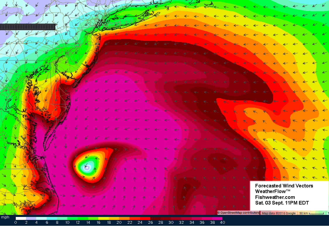
However, this storm on Saturday is predicted to still be moving relatively rapidly to the northeast and by Saturday night (above) you can see how the wind direction in some places has already changed as the overall dominant wind direction is counter-clockwise (cyclonic) around a low pressure sytem in the Northern Hemisphere. Saturday night, you can expect the flow of the surface water offshore of Virginia and North Carolina to now switch directions with the wind and move from inshore to offshore south of Norfolk Canyon, while the dominant flow of the water north of Norfolk Canyon will be still pushing into the bank from Washington Canyon to Hudson Canyon. This may continue to push the warmer (bluer) water that is now offshore of Washington to Toms Canyons farther inshore originally. Furthermore, you can see how the winds south of New York to Massachusetts are starting to set up blowing from east to west as will the flow of the surface water from the coast to the Atlantis to Hudson Canyons.
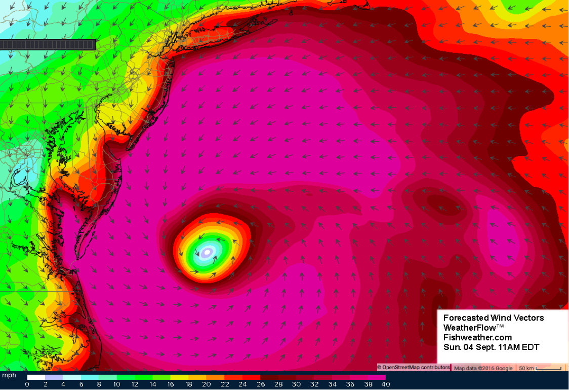
Next, we see the storm location and winds forecasted for Sunday morning as it moves a little farther to the northeast but now the overall movement of the center of the storm is slowing down and starting to set up offshore. We see the continual strong 30-40 mph and greater sustained wind around a very large area are of this storm. The winds will continue to push and mix water in an offshore direction east of North Carolina and Virginia and even Maryland while pushing water in an inshore direction and a south to southwest direction offshore of New Jersey to Delaware and mixing the offshore waters like a washing machine in and around the center of the storm near the offshore Norfolk and Washington Canyon area. Farther north we see the sustained winds starting to set up and remain similar for several hours from east to west offshore of Massachusetts to Long Island pushing the water from east to west over the northern canyon areas.
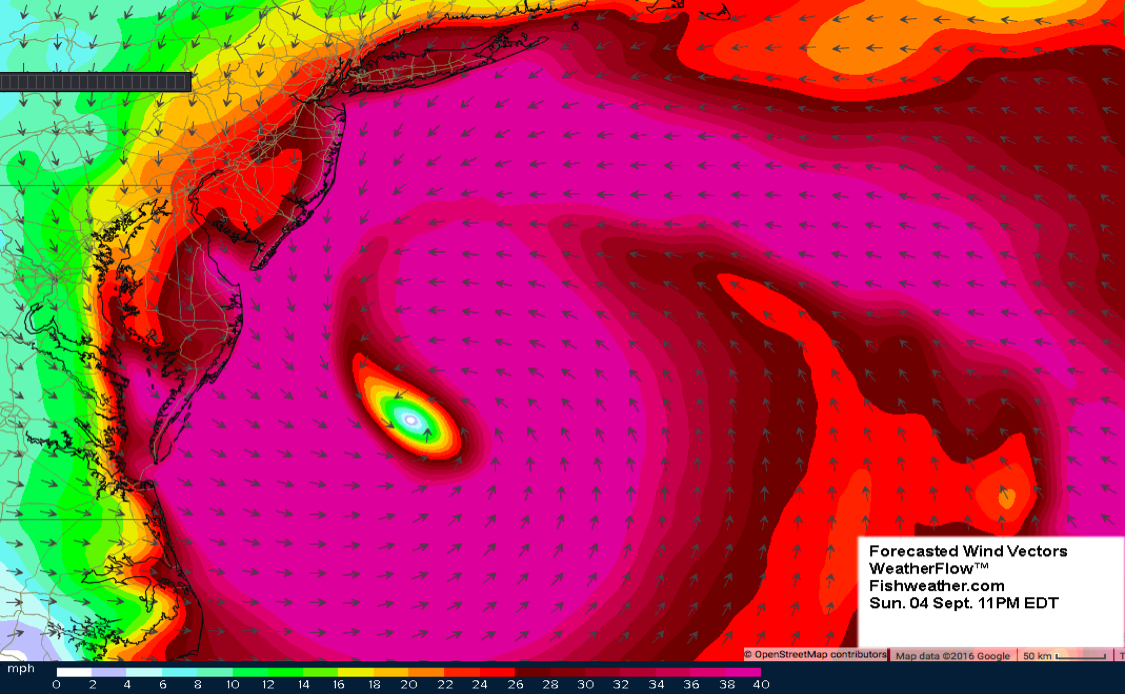
This next forecast shows the conditions and winds of Hermine on Sunday Night and there is little change in the overall wind locations and directions. If anything the wind is now intensifying blowing from east to west or southeast to northwest pushing water from offshore to inshore in the Oceanographer to Hydrographer Canyon area. We expect to see significant flow of water from offshore to inshore into the Baltimore to Hudson Canyon areas and offshore flow of water pushing the greener coastal water offshore from Washington Canyon south. Also, the way this storm has been sitting for the past 24 hours, a northern movement of the Gulf Stream edges can be expected toward the Block to Atlantis Canyon areas.
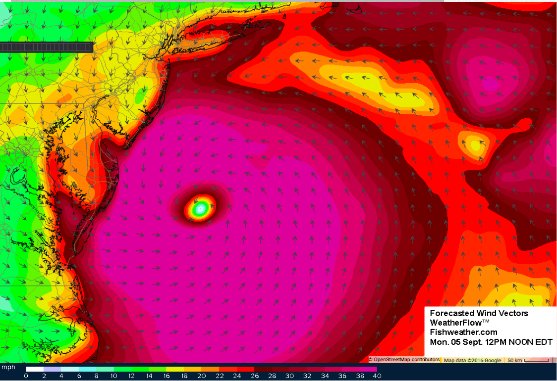
On Monday around noon the overall flow of the wind and reaction from the surface water is simlar as it was Sunday and the water and wind will continue to move quite rapidly from north or northeast to south or southeast along the coast and bank from New Jersey to Delaware pushing the large amounts of inshroe greener coastal water southward then offshore once it gets south of Delaware. It is also quite possible as this storm sets up and does not move much for the past 24 hours, that it will also effect location and momentum of the large eddy east of Hudson Canyon, pushing the eddy and related filament water more rapidly west to southwest toward Hudson and Toms Canyon and southwest toward Lindenkohl to Wilmington and Baltimore Canyons.
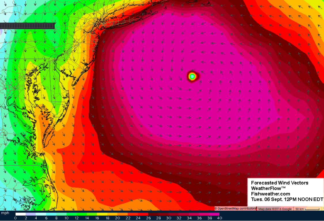
Now we jump ahead 24 hours to the forecast of where Hermine and the winds will be Tuesday around 12PM noon time. The storm has moved farther eastward and a little bit north putting the center of the storm somewhere south of Atlantis Canyon area. Now the winds have started to decline offshore of Virginia and North Carolina, but continue to blow 30-40 mph or more and intensify east of New Jersey and offshore of Long Island and south of Massachusetts. Now it appears it will be pushing the majority of the inshore surface water in an offshore direction mainly from the Fish Tails to Block Canyon area to Hudson Canyon area and south down the bank all the way to Norfolk Canyon. This will likley mix the inshore coastal water with the offshore Gulf Stream related filament water even more. Farther east the majority of the water will be pushing in an inshroe direction from Atlantis Canyon to Hydrographer Canyon to Oceanographer area. This is the last day it is forecasted for the winds to be affecting the very large offshore area.
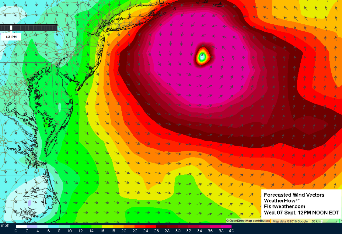
As we jump ahead another 24 hours for the forecast of the storm location and winds on Wednesday around 12PM noon time, we see the storm has now moved a little bit north toward Martha’s Vineyard and Nantucket Island area. However, it is important to notice that the forecast is for the storm to not move much for the past two days or even the next 24 hours (Tuesday, Wednesday and Thursday see the next figure). Therefore, we think that the longer time period that this storm and winds are in the similar direction and same location, the larger the effect it will have on the offshore waters. For example, how deep the flow of the water reacts to the wind is increased as the winds are stronger and in the same direction for a longer time period. Furthermore, the overall flow of surface water and wind mainly from north to south along the coasts of New Jersey and Delaware and the overall flow from east to west off the coast of Massashusetts to Long Island, New York sets up two highly likley possiblites. First of all, it will definitely increase the higher than normal tide on the coasts and offshore tidal flow over the bank and coastal flooding will be increased the longer this storm sits and spins offshore. Second of all, the laws of physical oceanography and dynamics dictate that the flow of the water (Ekman flow and Coriolis forces) will be to the right of the winds in the northern hemisphere. This will certainly push water in an inshore direction toward the coasts of Massashusetts, Rhode Island, Long Island New York, New Jersey down to Delaware and maybe Maryland further increasing the possiblity for higher than expected coastal water levels. Furthermore, the the majority of the offshore flow from Maryland south to Virginia and North Carolina may induce some upwelling along the coasts in that area further cooling and greening the water column near the coastal regions.
Thursday’s forecast looks nearly the same as the past two days. The overall flow of the wind and the predicted flow of the water will be similar and will further push water offshore from Block Canyon to Hudson Canyon and south to the southern canyons while pushing water inshore from Atlantis Canyons east to Veatch to Hydrographer Canyon. If anything it looks like the overall area coverage of the wind is reduced and maybe the storm by Thursday will start to die down. The eddy off of Hudson Canyon may now be pushed back south to southeast and offshore and mixed up a bit more with the wind direction changing. Furthermore, the other eddy south of Oceanographer Canyon will continue to be pushed farther north toward or into the bank for favorable fishing conditions from Hydrographer to Oceanographer Canyon areas after the storm moves through. By Thursday with the reduced winds in the south, it is possible that Thursday and Friday may be fishable in the Norfolk to Hatteras offshore areas.
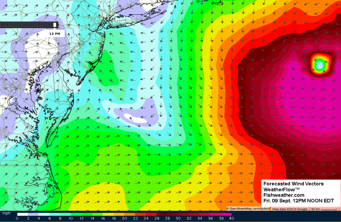
Finally, by late Thursday or Friday Hermine moves out of this area when the next front coming through pushes it farther east. With the movement of this storm eastward, the surface flow of the water and wind flow will be pushing water offshore (south) over the majority of the canyon areas from Fish Tails to Hydrographer Canyon to Oceanographer Canyon. It looks like by next weekend most people will be able to get offshore again and fish.
Overall, it is important to understand that the longer Hermine it sits offshore and does not move much it will have a larger impact on the ocean conditions. In fact, as this system sits offshore it has a good probability of developing back into Hurricane status as it circulates over warm northeast waters (80°F – 84°F) and the main core of the Gulf Stream water in this area for reference is approximately 84°F to 85°F. The main water mass boundaries and features such as the large eddies and Gulf Stream edges and locations will be impacted by this storm and will move in the direction the wind is blowing by a few miles or more. However, as we expect the main eddies to be influenced by Hermine and they may lose some momentum and intensity, the overall features should remain in tact and continue to be an offshore force and important factor for September fishing in the offshore areas after Hermine leaves. Please keep tuned into ROFFS™ and contact us to order your fishing forecasting analysis to see how the post-storm oceanographic conditions look so you can get back out fishing as soon as possible. The waters will eventually calm down and become stable by next weekend or shortly after depending on how long the storm sits offshore.