New/Updated Videos on ROFFS™.com – Be Sure to Check Out the “Hot News” Button on the ROFFS™ Homepage
Happy Holidays from ROFFS™!

REMINDER: ROFFS™ Closed WED & THUR 12/13 & 12/14 for annual meeting/retreat!
Please click HERE to watch the video on our website now!
Baja Striped Marlin!

Thetis Bank Baja California..just a 36 spine jarring mile ride out of Magdelena Bay… not another boat in sight…my kind of day! These are striped marlin also called stripers. I sent a voice to text message to a friend back home that translated my voice message to “filming strippers down in Baja, getting lots of good video and stills”…. He’s probably going to be a little disappointed with this post. Video Courtesy: Scott Hanson | Facebook
Please click HERE to watch the video on our website now!
Press Release – ROFFS™ Hurricane Harvey Rapid Response Project
December 5th, 2017
Roffer’s Ocean Fishing Forecasting Service, Inc. (ROFFS™) received a NASA grant to monitor the water outflow from Hurricane Harvey and study its possible effects on fisheries in the western Gulf of Mexico. Click here of full project description.
We are excited to announce that our proposal to the NASA Earth Science Mission Directorate was approved. The research is of high significance and likely to have a long-lasting impact due to the increased understanding of such events on the short-term and long-term impacts of tropical events on the fauna and flora in the Northwest Gulf of Mexico, along with the transport and fate of the polluted water offshore. The beneficial impacts to fisheries managers is that the resulting environmental data and analysis will be used for stock assessments which is mandated by the Magnuson – Stevens Fisheries Management Act in ecosystem based fisheries management. We believe that by incorporating the satellite derived environmental conditions into the stock assessment process will result in improved stock assessments and fisheries management. This project will map the impact of such major tropical storms on the distribution and concentration of terrestrial and ocean carbon fluxes by tracking the ocean color – chlorophyll signal along with the surface water current flow in the Northwest Gulf of Mexico, which is critical in understanding the carbon cycle through the ocean ecosystem and back to the atmosphere.
ROFFS™ will be providing weekly summaries and maps on the ROFFS™ website (roffs.com) and will be publicizing these data through social media, press releases, ROFFS™ Fishy Times Newsletter, and direct email to a variety of relevant agencies and fisheries managers. The distribution will focus primarily on scientists, fisheries – managers and fishers, and also the general public. If you would like to receive your personal copies and updates of this project then subscribe to the ROFFS™ Fishy Times Newsletter at https://roffs.com/insights/fishy-times-newsletter-signup/ or email fish7@roffs.com.

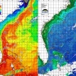
Figure 1. NASA MODIS Aqua ocean color image comparison of the conditions before (left) and immediately after (right) Hurricane Harvey from Texas to Louisiana. The dramatic difference in the amount of green – high chlorophyll water is substantially different off the Texas coast. Weekly Geo-TIFFS will be available of the classification analyses and results.
Please click HERE to read the FULL project description on our website now!
Updated Photos!

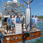
Nice Catch for ROFFS™ Client David Brown (So Reel) fishing offshore Port Aransas, TX.
Please click HERE to view more client photos on our website now!
Alaskan Storms!

Storms and strong winds are nothing new in Unalaska / Dutch Harbor. This video, from a security camera on the evening of November 26, 2017, shows the conditions at the City’s Light Cargo Dock located inside the shelter of Dutch Harbor. For those of you familiar with the area, this is inside the sand spit! It is unusual to have rough conditions like this at the dock. Wind gusts topped 105 mph that evening! The vessel in the foreground is Cape Caution. Video Courtesy: City of Unalaska, Alaska | Facebook
Please click HERE to watch the video on our website now!
Old School Boat Building!

1951: The newest, trendiest material to make boats out of was glass. Sort of… Video Courtesy: BBC Archive | Facebook
Please click HERE to watch the video on our website now!

Honor Vembu and donate to train the next generation of ocean experts!
Help us reach our $50,000 goal. It will enable SECOORA to establish an annual scholarship of approximately $2,500 in perpetuity in Vembu’s honor.
Please click here to donate now!
SPECIAL NOTE ****MD – SEA COAST – OCEAN CITY – BOTTOM MOORINGS****
The U.S. Naval Research Laboratory will be placing bottom moorings offshore of Ocean City Maryland in a 100 meter radius around 38° 21’ 50”N, 74° 45’ 51”W, approximately 15 NM, east by north, 081 degrees from Ocean City Inlet Jetty Light (LLNR 4720/225). The moorings will extend 1 meter off the bottom in 28 meters of water. Mariners are requested to not disturb these Navy experiments and to avoid dragging in the area. The moorings will remain in place till approximately Feb 23, 2018. Chart 12200, 12211

Please click HERE to read more on our website now!
Backlash? Feedback?

As always, please send comments & feedback on Fishy Times newsletter content directly to us at feedback@roffs.com.
If you do not want to wait for our next Fishy Times newsletter, please visit us in the meantime to get all your fishing news on Facebook, Instagram, Twitter, YouTube and on the web. Safe and successful fishing until next time!