Article originally published: March 23, 2018 | Courtesy: noaa.nesdis.gov | Please click here for original article.
[responsive]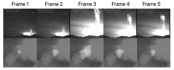 [/responsive]
Above: The image above shows a comparison in the optical energy from GLM and the camera on the ground.
NOAA GOES East (GOES-16) satellite’s Geostationary Lightning Mapper has captured the first images from space of ‘gigantic jet’ lightning – electrical discharges from a thunderstorm that come out the TOP of the storm and reach as high as the ionosphere (that’s 50 miles up).
Thunderstorms can produce electrical discharges that come out the top of the storm and reach the ionosphere (80 km altitude). These are known as gigantic jets. Jets have predominantly been recorded by cameras on the ground. However, new research using the GOES-16 Geostationary Lightning Mapper has identified gigantic jets from space that were produced by Tropical Storm Harvey as it passed Puerto Rico. This research can lead to a better understanding of these spectacular discharges and determine when and where they take place.