Gulf of Mexico Early Season Preview 2018
PROMISING FISHING CONDITIONS IN GULF OF MEXICO
By Daniel C. Westhaver and Matthew A. Upton
Please click here to download full preview as a PDF.
Introduction
As in previous years, ROFFS™ is providing an early spring analysis of the oceanographic conditions for the Gulf of Mexico region using a combination of satellite data including sea surface temperature (SST) and ocean color/chlorophyll images from mid-to-late March 2018. We will discuss the overall ocean conditions for the current spring fishing season and how they may transition into the summer conditions compared to the same time last year.
Roffer’s Ocean Fishing Forecasting Service, Inc. – ROFFS™ (roffs.com) has a 30+ year history of monitoring the ocean conditions throughout the Gulf of Mexico for research and fishing applications. Infrared (IR) satellite data is used to observe the SST and ocean color data is used to derive indices of phytoplankton (chlorophyll), water clarity, and colorized dissolved organic material (CDOM). Combined with other oceanographic data and in sequence, these data allows one to visualize the dynamic surface ocean currents. The satellite data is derived from a variety of sources including NASA, NOAA, Suomi National Polar-orbiting Partnership (SNPP), and the European Space Agency (ESA). ROFFS™ also uses a plethora of different data derived from drifting buoys, gliders, aircraft, fishing vessels, and satellite altimeters. The altimeter data provides a relatively coarse spatial (~15 mile) and temporal resolution (5-10 days) that limits the data’s usage for studying large-scale circulation. It is not useful for evaluating smaller scale and short-term (daily and sub-daily) changes in the ocean currents or their water mass boundaries that control the location of forage fish and the larger, more valuable predator fish.
Background and Some Observations for 2018
It is important to look at the year-to-year trends and anomalies to get a better understanding of how the ocean conditions compare regarding the conditions and location of the fishes preferred habitat and the likelihood of a productive fishing year. Comparing the similar locations and features to last year, the SST of the core of the Loop Current for late-March 2017 was 81.5°F, and for this year over the same time period, it was 80.6°F, which is cooler than last year and more in line with previous years since last year was a relatively warmer year. Furthermore, the SST this year in the offshore northwestern Gulf of Mexico area is 71.5°F-73.0°F, which is approximately 1.5°F cooler than last year at this time. The SST in the offshore southwestern Gulf of Mexico area was observed to be within the 76.0°F – 77.0°F range this year, which is similar to last year, but much warmer than in 2016. Also of note is that the coastal SST’s along the west coast of Florida to the western Gulf of Mexico are showing temperatures approximately 3.0°F to 5.0°F cooler than last year, but still were warmer than they were during the same time period (late-March) during 2016. It appears that this years SST’s throughout the Gulf of Mexico are somewhere between the cool 2016 year and warm 2017 year. It remains to be seen if 2016 was a much cooler than normal year or if 2017 was a much warmer than normal year for the late March time period.
These cooler than last year SST readings throughout the Gulf of Mexico are likely related to the higher winds and cooler atmospheric temperatures this spring compared to last year. This suggests a slight delay in the arrival of larger pelagics (tuna, wahoo, dolphin, marlin, kingfish) closer to the coast and traditional fishing grounds compared to last year. We have heard that the stronger than normal spring winds over the past months associated with the multiple fronts have made it difficult for offshore fishing. However, when the weather permits, there have also been some recent reports of scattered sailfish west of Tampa and marlin, wahoo and good yellowfin tuna action south of Louisiana and in the northeastern Gulf of Mexico. These good reports south of Louisiana are likely due to the large dominant Loop Current eddy located south of Louisiana (Figure 1).
Due to the various joint NASA – NOAA research projects that we have been involved in for the past 10 years we have learned more about the importance of the connectivity between the Gulf of Mexico and North Atlantic Ocean system. Thus, as we considered in our Bahamas seasonal forecast, we are paying more attention to the large scale circulation such as the Atlantic Multidecadal Oscillation (AMO). The AMO has been identified by some as a coherent mode of natural variability occurring in the North Atlantic Ocean with an estimated period of 60-80 years. It is based upon the average anomalies of sea surface temperatures (SST) in the North Atlantic basin, typically over 0°- 80°N latitude. (https://climatedataguide.ucar.edu/climate-data/atlantic-multi-decadal-oscillation-amo).
The unsmoothed AMO Index for January and February 2016 was 0.238 and 0.163 respectively. In 2017 the January and February values were 0.233 and 0.234, and in 2018 they were 0.173 and 0.063 respectively. We have learned from our colleagues at NOAA that a positive trend in these AMO indices suggest that a slowdown of the North Atlantic Ocean Circulation is occurring. This includes a slowing of the Gulf Stream system including the Loop Current, which supports some recent research results. Although there continues to be a positive trend in the AMO this year, the smaller values could explain why the Loop Current has pushed further north into the Gulf Stream, unlike last year when it stayed south of Naples for the majority of the summer. Whether the velocity this year is significantly different from the past remains to be seen. We have learned that the currents are highly variable from year-to-year and season-to-season so we will continue to monitor these conditions to see if we notice any trends.
Note also, a positive AMO is usually associated with an increase in the number of tropical storms that mature into hurricanes because the overall North Atlantic Ocean and Gulf of Mexico SST is higher (i.e., higher anomalies). This does not take into account the wind shear variability and other aspects of tropical storm genesis. For easy to understand answers to frequently asked questions about the AMO see http://www.aoml.noaa.gov/phod/amo_faq.php#faq_2.
Regarding El Niño – Southern Oscillation, presently we continue to remain in La Niña, but just barley. Generally, this means the seasonal climate impacts will be weakened and neutral (normal) conditions are likely over the next few months within the Gulf of Mexico Region. We will continue to investigate the relationship between these larger oceanographic oscillations and relationships to the oceanographic conditions and fishing in the Gulf of Mexico waters. We have included this information to spark your interest in climate indices.
Nowcast Analysis
For forecasting short-term oceanographic conditions related to finding fish, ROFFS™ uses real-time direct observations rather than unproven ocean models and longer-term composites. We have learned that evaluating the preseason conditions along with regional climate models provides insight into future seasonal trends for fishing. Experience and understanding the ocean – atmospheric dynamics is our guide as we have had moderate success in forecasting seasonal trends of fishing productivity based on the stepwise progression in the location of the fishes’ preferred habitat based on temperature and water color.
The circulation of the Gulf of Mexico is controlled by the location and flow of the Loop Current, large mesoscale eddies, local and regional winds, and the dynamic thermohaline forces of the fresh water runoff mixing with the ocean water. The Loop Current is a warmer ocean current that flows northward between Cuba and the Yucatan Peninsula into the Gulf of Mexico. It makes a “loop” eastward within the Gulf then southward before exiting through the Straits of Florida and re-joining the Gulf Stream. It is the dominant circulation feature in the eastern Gulf of Mexico and its location varies on a monthly and annual time scales. The Loop Current can be a highway for pelagic fish moving into the Gulf of Mexico from the Caribbean Sea. The eddies that the Loop Current sheds can be an important fish habitat for longer periods of time as they progress from the eastern Gulf of Mexico to the western Gulf of Mexico over several months.
Figure 1 was derived from a variety of U.S. (NASA, NOAA, JPSS and ESA) satellites during the late-March (March 22-23, 2018) period and Figure 2 was derived from the U.S. SNPP VIIRS, Aqua MODIS and Terra MODIS ocean color/chlorophyll imagery during this same period (March 17-26, 2018). As the exact values of the original data from different satellite sensors (VIIRS and MODIS) are not the same, we cross-calibrated the data to derive images that had realistic and consistent water color. This is one of the many techniques that we derived during the valuable NASA Earth Science Program projects that ROFFS™ has been involved with.
We could not use single and same day imagery for the SST and especially the ocean color data due to cloud cover interference, so we used a combination of imagery and the time-tested ROFFS™ cloud reduction techniques to produce these relatively cloud-free images. However, for comparison purposes we consider these images as an equal image pair for the purposes of this discussion. The directional flow, not speed of the water was derived from our ROFFS™ sequential image analysis, following the water image to image based on the water masses distinct, i.e. signature value. An example of this years SST satellite infrared imagery in greytone can be found on the ROFFS™ YouTube™ site (https://www.youtube.com/watch?v=tzJ7YgxXKvU). Viewing the movie will allow one to follow the flow of the water within the Gulf of Mexico region during the last two months, where the darker greytoned water represents the warmer water and white indicates clouds.
When evaluating this years late-March oceanographic conditions we are already able to observe some promising features such as the intrusion and northern location of the main body of the Loop Current and a large clockwise rotating Loop Current eddy feature centered offshore of the Mississippi Canyon near 89°45’W & 27°20’N. This Loop Current eddy is pulling warmer blue water into the canyons feeding smaller counter clockwise rotating eddy features between South Pass and Cape San Blas with blue water inshore to over the Nipple and Steps areas. These conditions could account for the recent early season catches of yellowfin tuna, dolphin, wahoo, and marlin in the northeastern Gulf. We expect that this eddy and its related spin off eddies will continue to provide favorable fish habitat closer to the Mississippi Canyon and Green Canyon and inshore of De Soto Canyon during the months of April and May and further west into the summer as this main Loop Current eddy continues its traditional westward drift.
[responsive]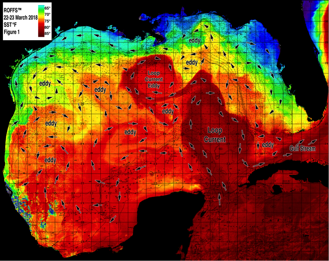 [/responsive]
Figure 1: This year’s Gulf of Mexico conditions were derived from a variety of infrared sensors to get SST from NASA, NOAA, and JPSS satellites during March 22-23, 2018. Main features and surface currents are labeled.
Of note, this main Loop Current eddy that is south of Louisiana and the more northern location of the Loop Current feature was absent for much of the fishing season last year until late summer. These features already have distributed large amounts of blue 72°F-78°F water (preferred fish habitat) within many popular fishing areas around the eastern Gulf of Mexico providing some favorable early season offshore fishing action for, tuna, dolphin, wahoo, sailfish and early season marlin. Offshore of Texas, warmer water (70°F-73°F) has migrated inshore of 100 fathoms from the East Breaks to the Colt 45 region where conditions are already improved over last year where greener water was located as far offshore as 500 fathoms for the majority of the fishing season in the northwest Gulf of Mexico. Additionally, the northern location of the Loop Current has brought large amounts of blue (71°F-76°F) and mixed blue Loop Current water inshore as far as 40-50 fathoms off the west coast of Florida, providing some improving fishing action with cobia, wahoo, kingfish and sailfish.
[responsive]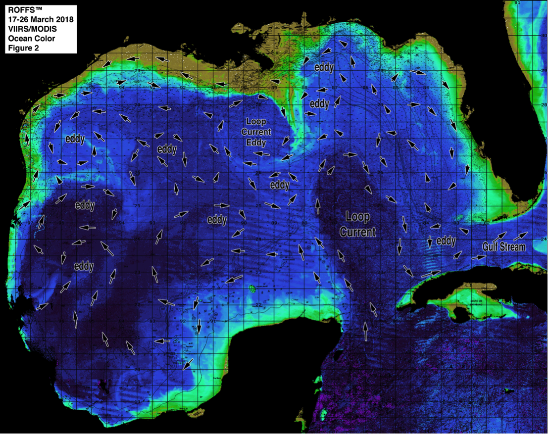 [/responsive]
Figure 2: This year’s Gulf of Mexico conditions derived from the ocean color/chlorophyll imagery during March 17-26, 2018 from the VIIRS sensors on SNPP satellite in combination with the Aqua and Terra sensors on the MODIS satellite. We consider this an image pair with the above SST Figure1 image. Same main features and surface currents labeled.
Conclusion
Based on what we have been observing over the last few weeks, the present ocean conditions for the Gulf of Mexico region appears cooler than last year, but still warm enough for preferred fishing habitat in the traditional offshore fishing zones within the Gulf of Mexico this spring season. The northern presence of both the Loop Current and this main Loop Current eddy features that were absent last year already makes this years conditions look more favorable in the mid-to-eastern Gulf of Mexico than last year. The northern push of the Loop Current along with this recently shed main Loop Current eddy will continue to provide warmer/bluer water over these traditional fishing structures and closer to the coast than last year allowing the already favorable fishing conditions to continue through the summer. Even though the majority of the inshore water is still relatively cool compared to last year at this time, with the increasing atmospheric temperatures and proximity of the Loop Current related features (especially in the eastern Gulf of Mexico), the inshore kingfish, cobia and then the tuna, wahoo, dolphin and marlin action will soon heat up.
Offshore of Texas, cleaner and bluer water than last year within the 70°F – 74°F habitat is already providing promising conditions for this spring season and all signs point to it improving into the summer season. Furthermore, ROFFS™ has just posted some of the results of a NASA funded Rapid Response research project monitoring and identifying Hurricane Harvey runoff water into the Gulf of Mexico, click here to look at the preliminary results on our web site and stay tuned for the final report. We hope that the effects of Hurricane Harvey and related outflow does not significantly impact fisheries and spawning action in the northwest Gulf of Mexico. Overall, according to the present oceanographic conditions, we think that the Gulf of Mexico has the potential for GOOD to EXCELLENT fishing action. Therefore, it is already time to start fishing once the weather permits. As always the concern is that the water does not get too warm, too soon and push the fish deeper into the water column or force them to exit the Gulf of Mexico earlier than normal.
It is important to note that good fishing action on a daily basis is strongly linked to local, short-term (days) current conditions that concentrate the fish once the preferred habitats of the fish are in a particular region. When the water mass boundaries associated with these currents are geographically stable and favorable, i.e., persistently pushing over “good” bottom topography and/or in a favorable inshore direction, then they concentrate the baitfish and larger fish can be found foraging. This indicates that the fishing action on any given day is controlled by relatively short term (hourly to daily) and relatively small scale (1-5 mile) movements of the currents and their water mass boundaries. Our experience indicates that to reliably forecast specific concentrations of fish on a daily basis one must evaluate the ocean conditions on these scales. Relatively small subtle changes in the currents and their associated water mass boundary zones often have dramatic effects on the distribution and concentration of fish.
Contact ROFFS™ (321-723-5759 / fish7@roffs.com / roffs.com) for the daily real-time detailed fishing forecasting analyses and get the inside track to where the better conditions will be tomorrow. We continue to monitor these Gulf of Mexico conditions and how they change from day-to-day as the larger recreational and tournament fishing season approaches. The bottom line is GET READY and GET OFFSHORE NOW, for the early season GOOD fishing conditions have already started and should continue through April into May and June.
Safe and Successful Fishing