Southern Florida to Cape Hatteras Spring Season Preview 2018
UPDATE ON U.S. EAST COAST GULF STREAM CONDITIONS
By ROFFS™ | Gregory J. Gawlikowski
Please click here to download full preview as a PDF.
ROFFS™ continues its spring preview series by providing an overall update of the oceanographic conditions during early April for the east coast of the United States from the Florida Keys north to Cape Hatteras, NC including the entire offshore Gulf Stream region. As always, we have used a combination of many different data sets, but mainly sea surface temperature (SST) and ocean color/chlorophyll images. We will discuss these overall ocean conditions for the present spring season and how these conditions may translate to the near future fishing season.
For forecasting short-term oceanographic conditions related to finding fish, ROFFS™ uses real-time direct observations rather than unproven ocean models and longer-term composites. We have learned that evaluating the preseason conditions along with regional climate models provides insight into future seasonal trends for fishing. Experience and understanding the ocean – atmospheric dynamics is our guide as we have had moderate success in forecasting seasonal trends of fishing productivity based on the stepwise progression in the location of the fishes’ preferred habitat based on temperature and water color. Please reference our 2018 Bahamas forecast for more in-depth discussion on the environmental and climate indicators that goes into our detailed evaluation of the southeastern United States fishing forecasting analysis (Click Here).
Background and Some Observations for 2018
It is important to look at the year-to-year trends including the anomalies to gain insight into the location and condition of the fishes’ preferred habitat compared with previous years. Comparing similar locations and features to last year during the same early April time period we found that the SST of the core of the Gulf Stream off of Miami, FL for 2017 was approximately 79.6°F and for this year it is approximately 1.0°F cooler at approximately 78.6°F (1.5°F cooler from 2016 when the SST was 80.1°F). Offshore of Jacksonville, FL the SST of the core of the Gulf Stream appears to be approximately 77.7°F, which is approximately 1.0°F cooler from what we observed last year in 2017. Farther northward off of Charleston, SC the SST of the core of the Gulf Stream for early April 2017 was approximately 78.5°F and for this year it is also relatively cooler (77.5°F). Continuing northward off of Cape Lookout, NC, the SST of the core of the Gulf Stream for 2017 was approximately 76.0°F – 76.5°F and this year the SST is approximately 76.5°F, which is similar to last year during this same early April time period. Therefore, between the FL Keys to Miami to Jacksonville and as far northward as Charleston, SC the SST of the core of the Gulf Stream appears to be 1.0°F-1.5°F cooler this year. This could indicate a slightly later arrival (1-2 weeks dependent on weather conditions) for the larger population of tuna, wahoo, dolphin and even marlin in these areas compared to last year.
Furthermore, we studied the SST for the near coastal waters (~ 10-12 miles east) in a few different locations along the southeast coast of the United States and compared it to last year at this time. Overall, the SST off of Cape Canaveral for both years were approximately 71.0°F – 73.0°F. The SST in the Gray’s Reef region appear cooler (63.0°F-65.0°F) for 2018 in comparison to 2017 (66.0°F- 67.0°F) during this same early April time period. The SST off of Charleston, SC for both 2017 and 2018 were approximately 63.0°F- 65.0°F. Farther northward between Cape Fear and Cape Lookout within Onslow Bay the SST for 2017 was approximately 60.0°F to 61.0°F compared to 61.0°F-63.0°F this year (2018), which is actually slightly warmer from last year. We are uncertain to what this means in the longer-term as the recent cooler air temperatures from the cold fronts and associated winds appeared to have lowered the near shore SST’s in many locations. However, as of early April the Gulf Stream conditions look slightly cooler while the inshore SST looks to be similar to last year’s conditions in many places. This may suggest that the fish will remain in the Bahamas a bit longer (perhaps 1-2 weeks dependent on weather conditions) before moving west to the Gulf Stream and then north. Click here for the ROFFS™ review of the Bahamas conditions.
Nowcast Analysis
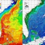
The Gulf Stream Current including its related eddies and filaments along the current’s eastern and western side are the preferred habitat of the highly migratory species for this time of year and are the most important conditions that we are studying. It is the day-to-day and hour-to-hour movements of these Gulf Stream related features that are important to monitor when deciding where to fish on a daily basis. Although we are only showing a two-to-three-day snap shot of the conditions in this report from early April (Figure 1a/b and 2a/b), we can discuss briefly the trends we see based on these early spring oceanographic conditions and related fishing reports that may provide insight into the near-future fishing season.
Figures 1a/b were derived from a variety of U.S. and European satellites during the early April (April 02-04, 2017/2018) period and Figures 2a/b were derived from U.S. SNPP VIIRS, Aqua MODIS and Terra MODIS ocean color/chlorophyll imagery during this same period (April 02-04, 2017/2018). As the exact values of the original data from different satellite sensors (VIIRS and MODIS) are not the same, we cross-calibrated the data to derive images that have realistic and consistent watercolor. This is one of the many techniques that we derived during the valuable NASA Earth Science Program projects that ROFFS™ has been involved with. We cannot over-stress the importance of NASA’s Earth Science Program for helping to understand the ocean’s dynamic ecosystem and how it impacts food security, homeland security and land-ocean interactions.
[responsive]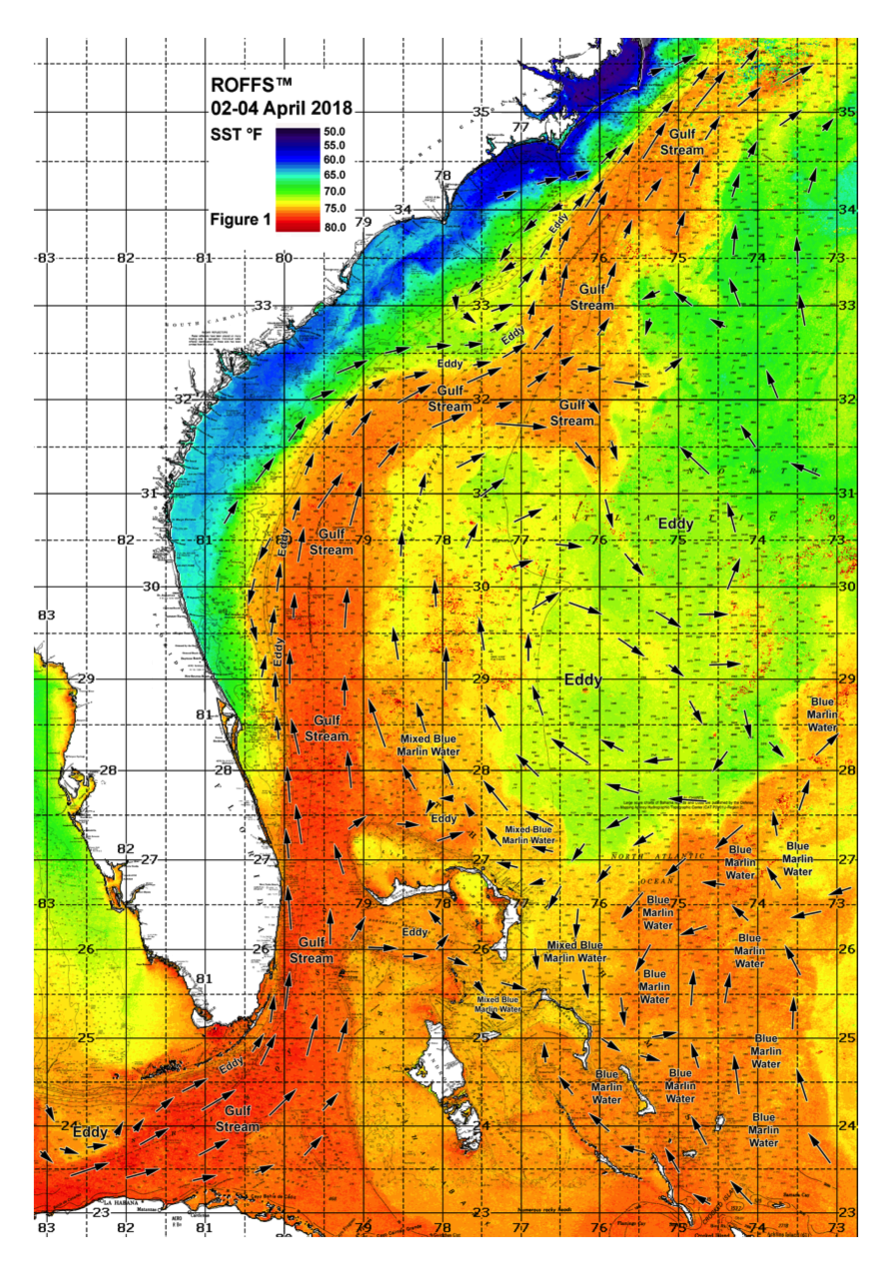 [/responsive]
Figure 1a: This year’s Florida Keys to Cape Hatteras, NC conditions were derived from a variety of infrared sensors to get SST from NASA, NOAA, JPSS and ESA satellites during April 02-04, 2018. Main features and surface currents are labeled.
[responsive]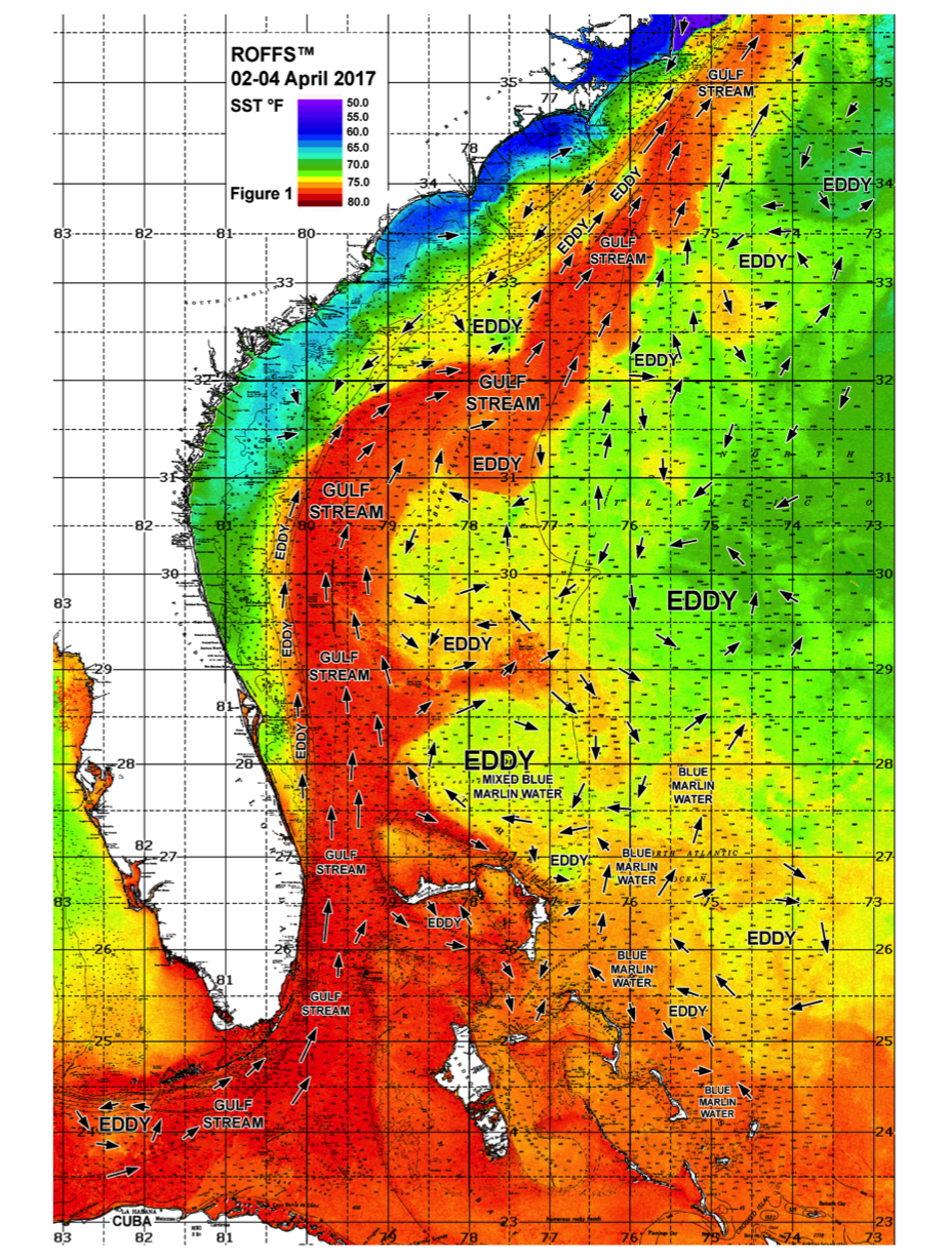 [/responsive]
Figure 1b: Last year’s Florida Keys to Cape Hatteras, NC conditions were derived from a variety of infrared sensors to get SST from NASA, NOAA, JPSS and ESA satellites during April 02-04, 2017. Main features and surface currents are labeled.
[responsive]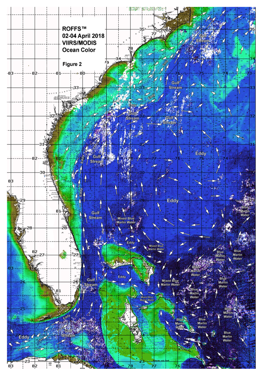 [/responsive]
Figure 2a: This year’s Florida Keys to Cape Hatteras, NC conditions derived from the ocean color/chlorophyll imagery during April 02-04, 2018 from the VIIRS sensors on SNPP satellite in combination with the Aqua and Terra sensors on the MODIS satellite. We consider this an image pair with the above SST Figure 1a image. Same main features and surface currents labeled.
[responsive]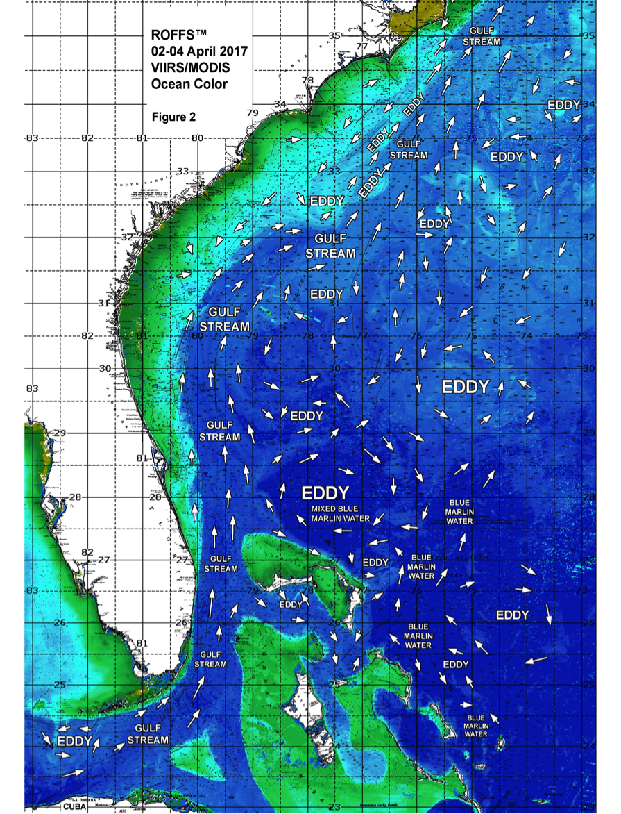 [/responsive]
Figure 2b: Last year’s Florida Keys to Cape Hatteras, NC conditions derived from the ocean color/chlorophyll imagery during April 02-04, 2017 from the VIIRS sensors on SNPP satellite in combination with the Aqua and Terra sensors on the MODIS satellite. We consider this an image pair with the above SST Figure 1b image. Same main features and surface currents labeled.
We could not use single and same day imagery for the SST and ocean color data due to cloud cover interference, so we used a combination of imagery and the time-tested ROFFS™ cloud reduction techniques to produce these relatively cloud-free images. However, for comparison purposes we consider these images as an equal image pair for the purposes of this discussion. The directional flow of the water was derived from our ROFFS™ sequential image analysis, following the water image to image based on the water masses distinct, i.e. signature value. An example of this years SST satellite infrared imagery in greytone can be found on the ROFFS™ YouTube™ site (Click Here). Viewing the movie will allow one to follow the flow of the water and numerous eddies within the Gulf Stream region from offshore of eastern and southern Florida to North Carolina during the last month, where the darker greytoned water represents the warmer water and white indicates clouds.
Conclusion
Based on what we have been observing over the last several weeks, the present overall early April ocean conditions (SST) for the Gulf Stream region between the Florida Keys to Cape Hatteras, NC appears cooler than what we had observed last year. However, as the air temperatures warm up over the next month, so will the SST. We have noticed many promising conditions and have received many positive fishing reports already this year including but not limited to: good wahoo action off of St. Augustine, FL to Charleston, SC, good sailfish action earlier this year and continuing in many places off eastern and southern Florida and the start of some mahi catches off of Cape Canaveral to southern Florida. This implies that the early spring fishing season for both the coastal and offshore areas will continue to improve through spring and into the summer season including the Bahamas region. Mild to warmer spring weather over the next few weeks will allow the coastal areas to warm (along with the Gulf Stream) allowing the offshore fish to move northward in the Gulf Stream and also closer to the coast.
This means you should be either fishing already or your boat should be in the water waiting for that weather window. We want you to take advantage of the good ocean conditions and the early fishing season. Once the water continues to warm after the last of the seasonal cool fronts pass through, the offshore fishing season will have begun over most of the areas from Cape Canaveral to Cape Hatteras. It will not be long until the main migration of marlin, yellowfin tuna and mahi will be available off of North and South Carolina.
It is important to note that good fishing action on a daily basis is strongly linked to local, short-term (days) current conditions that concentrate the fish once the preferred habitats of the fish are in a particular region. When the water mass boundaries associated with these currents are geographically stable and favorable, i.e., persistently pushing over “good” bottom topography and/or in a favorable inshore direction, then they concentrate the baitfish and larger fish can be found foraging. This indicates that the fishing action on any given day is controlled by relatively short-term (hourly to daily) and relatively small-scale (1-5 mile) movements of the currents and their associated water mass boundaries. Our experience indicates that to reliably forecast specific concentrations of fish on a daily basis one must evaluate the ocean conditions on these scales. Relatively small subtle changes in the currents and their associated water mass boundary zones often have dramatic effects on the distribution and concentration of fish.
The Gulf Stream conditions change rapidly so it becomes even more important to contact ROFFS™ (321.723.5759 / fish7@roffs.com / roffs.com) for the daily up-to-date detailed fishing forecasting analyses and get the inside track to where the better conditions will be tomorrow. We continue to monitor the coastal southeastern U.S. ocean conditions especially the Gulf Stream and its related eddy features and how it relates to the local fishing environment as the larger recreational and tournament fishing season approaches. Get out and fish now and maximize your fishing experience by using ROFFS™ to locate the good spring conditions near you.
Safe and Successful Fishing