Click here to download full forecast as a PDF.
Gulf of Mexico Early Season Preview 2019
EARLY SEASON CONDITIONS LOOK EXCELLENT IN THE GULF OF MEXICO
By Gregory J. Gawlikowski
Introduction
This year, ROFFS™ is providing a spring analysis of the oceanographic conditions for the Gulf of Mexico region derived using a combination of high-resolution satellite data including sea surface temperature (SST) and ocean color/chlorophyll images from mid-to-late April 2019. In this feature, we will discuss the overall ocean conditions for the current spring fishing season and how they may transition into the summer conditions compared to the similar time period last year.
ROFFS™ (roffs.com) has a 30+ year history of monitoring the ocean conditions throughout the Gulf of Mexico for research and fishing applications. Infrared (IR) satellite data is used to observe the SST and ocean color data is used to derive indices of phytoplankton (chlorophyll), water clarity, and colorized dissolved organic material (CDOM). Combined with other oceanographic data and in sequence, these data allows one to visualize the dynamic ocean currents. The satellite data is derived from a variety of sources including NASA, NOAA, Suomi National Polar-orbiting Partnership (SNPP), the University of Delaware and the European Space Agency (ESA). ROFFS™ also incorporates a variety of different data derived from drifting buoys, gliders, aircraft, fishing vessels, and satellite altimeters into its fishing forecasting analyses. The altimeter data provides a relatively coarse spatial (~15 mile) and temporal resolution (5-10 days) that limits the data’s usage for studying large-scale circulation. It is not useful for evaluating smaller scale and short-term (daily and sub-daily) changes in the ocean currents or their water mass boundaries that control the location of forage fish and the larger, more valuable predator fish.
Background and Some Observations for 2019
It is important to look at the year-to-year trends and anomalies to get a better understanding of how the ocean conditions compare regarding the conditions and location of the fishes preferred habitat and the likelihood of a productive fishing year. Comparing the similar locations and features to last year, the SST of the core of the Loop Current for late-March 2018 was 80.6°F, and for this year over the same relative time period (mid-to-late April 2019), it was 83.4°F, which is warmer than last year and warmer overall compared to previous years. The main body of the Loop Current appears to show warmer overall temperatures this year and the other areas within the Gulf of Mexico are continuing to show the warming trend we observed over the past two to three years. The SST in the offshore northwestern Gulf of Mexico is generally 78.0°F-79.0°F, which is approximately 2.0°F-3.0°F warmer than last year. Similarly, the SST in the offshore southwestern Gulf of Mexico area was observed to be within the 81.0°F – 82.0°F range this year, which is much warmer than the 76.0°F-77.0°F that was observed last year. Also of note is that the coastal SST’s along the west coast of Florida to the western Gulf of Mexico are showing temperatures similar to last year, but continue to range 4.0°F – 5.0°F higher than they were during the same time period (late-March to mid-April) as in 2016-2017.
Much of this warmer trend may be due to the additional 4 weeks of spring warming since we are using SST images a month later this year compared to last year due to factors such as clearer imagery availability and scheduling. Another contributor of the warmer than normal SST’s is we are currently in a mild El Niño year and it is forecasted by NOAA to remain an El Niño year through the summer which traditionally equates to warmer than normal SST in the Gulf of Mexico region.
Although at this time there is no presence of a large Loop Current eddy feature like we observed last year, and did not observe until late in the summer in 2017, there is a large pool of relatively warmer (77.0°F-79.0°F) blue water that continues to be pulled off of the northern edge of the main circulation of the Loop current that continues to progress west/northwest of the Atwater Valley, east/northeast of the Green Canyon and northward towards the area within 15-20 miles south of the South Pass and Southwest Pass, LA areas. These substantially warmer SST’s, which are similar to last year, suggest an earlier arrival time of the species that you usually target in May (e.g. yellowfin tuna, wahoo, dolphin, kingfish, sailfish, marlin, swordfish, cobia, etc.). Recent reports indicate that the cobia have arrived offshore (south) of the Florida panhandle and kingfish action has been good so far in March and April off of western Florida with scattered sailfish and dolphin also being caught offshore of Tampa, FL. We have also had reports of larger bluefin tuna caught in the northeast Gulf of Mexico in mid-to-late March. There have also been some reports of marlin, wahoo and also yellowfin tuna action south of Louisiana and in the northeastern Gulf of Mexico which is not surprising based on the SST’s we have been observing in the areas east/northeast of the Green Canyon, towards the Mississippi Canyon and towards the area south of the Mississippi River Delta over the past two weeks. Towards the De Soto Canyon area blackfin tuna, sailfish and dolphin have also been reported. In the western Gulf of Mexico there have already been reported releases of marlin in the Perdido Rig and Hoover Diana Rig and also good yellowfin tuna action.
Nowcast Analysis
For forecasting short-term oceanographic conditions related to finding fish, ROFFS™ uses real-time direct observations based on high-resolution satellite data rather than unproven ocean models and longer-term composites. We have learned that evaluating the preseason conditions along with regional climate models provides insight into future seasonal trends for fishing. Experience and understanding the ocean – atmospheric dynamics is our guide as we have had moderate success in forecasting seasonal trends of fishing productivity based on the stepwise progression in the location of the fishes’ preferred habitat based on temperature and water color.
The circulation of the Gulf of Mexico is controlled by the location and flow of the Loop Current, large mesoscale eddies, local and regional winds, and the dynamic thermohaline forces of the fresh water runoff mixing with the ocean water. The Loop Current is a warmer ocean current that flows northward between Cuba and the Yucatan Peninsula into the Gulf of Mexico. It makes a “loop” eastward within the Gulf then southward before exiting through the Straits of Florida and re-joining the Gulf Stream. It is the dominant circulation feature in the eastern Gulf of Mexico and its location varies on a monthly and annual time scales. The Loop Current can be a highway for pelagic fish moving into the Gulf of Mexico from the Caribbean Sea. The eddies that the Loop Current sheds can be an important fish habitat for longer periods of time as they progress from the eastern Gulf of Mexico to the western Gulf of Mexico over several months.
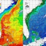
Figure 1a was derived from a variety of U.S. (NASA, NOAA, JPSS and ESA) satellites during the mid-April (April 20-22, 2019) period and Figure 2a was derived from the U.S. SNPP VIIRS, Aqua MODIS and Terra MODIS ocean color/chlorophyll imagery during this same period (April 19-22, 2019). As the exact values of the original data from different satellite sensors (VIIRS and MODIS) are not the same, we cross-calibrated the data to derive images that had realistic and consistent water color. This is one of the many techniques that we derived during the valuable NASA Earth Science Program projects that ROFFS™ has been involved with.
Figure 1b was derived from a variety of U.S. (NASA, NOAA, JPSS and ESA) satellites during the late-March (March 22-23, 2018) period and Figure 2b was derived from the U.S. SNPP VIIRS, Aqua MODIS and Terra MODIS ocean color/chlorophyll imagery during this same period (March 17-26, 2018).
We could not use single and same day imagery for the SST and ocean color data due to cloud cover interference, so we used a combination of imagery and the time-tested ROFFS™ cloud reduction techniques to produce these relatively cloud-free images. However, for comparison purposes we consider these images as an equal image pair for the purposes of this discussion. The directional flow, not speed of the water was derived from our ROFFS™ sequential image analysis, following the water image to image based on the water masses distinct, i.e. signature value. An example of this years SST satellite infrared imagery in greytone can be found on the ROFFS™ YouTube™ site (Click here.). Viewing the movie will allow one to follow the flow of the water within the Gulf of Mexico region during the last two months, where the darker greytoned water represents the warmer water and white indicates clouds.
When evaluating this year’s mid-April oceanographic conditions we are already able to observe the intrusion and northern location of the main body of the Loop Current towards the Atwater Valley and a large pool of clean blue water being pulled west/northwestward towards the area east/northeast of the Green Canyon, towards the Mississippi Canyon and further northward towards the areas offshore of the Mississippi River Delta region. These conditions likely account for the recent early season catches of bigger yellowfin tuna, dolphin, wahoo, and blue marlin in the northeastern Gulf of Mexico. We have seen this clean blue water pushing closer to (and within 15-20 miles of) the Mississippi River Delta over the past two weeks and we would not be at all surprised if the fish are spread inshore towards the De Soto Canyon, Spur and Nipple areas during the month of May. Overall, we notice that the main edges of the Loop current are expanded further east and west (especially closer to Florida) than this similar time period last year. Also, the shape and rotation of the Loop Current, suggests a large Loop Current eddy may break off over the next month and start migrating west. Stay tuned and call ROFFS™ to get updated conditions within this entire Gulf of Mexico region to find the best locations to fish nearest to your inlet.
Offshore of Texas, warmer than normal blue water (79°F-80°F) has migrated inshore of 100 fathoms towards the Colt 45 region and also northeastward towards the East Breaks area suggesting a good offshore fishing action east/southeast of Texas as well. Additionally, the location of the Loop Current has brought large amounts of blue (76°F-79°F) and mixed blue/blended blue Loop Current water inshore as close as 20-30 fathoms offshore of the west coast of Florida, providing the current favorable conditions for fishing action with cobia, wahoo, kingfish and sailfish and even scattered sailfish and blackfin tuna.
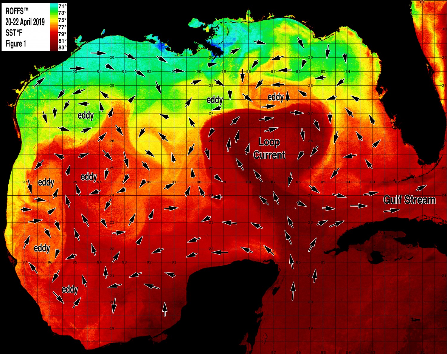
Figure 1a: This year’s Gulf of Mexico conditions were derived from a variety of infrared sensors to get SST from NASA, NOAA, and JPSS satellites during April 20-22, 2019. Main features and surface currents are labeled.
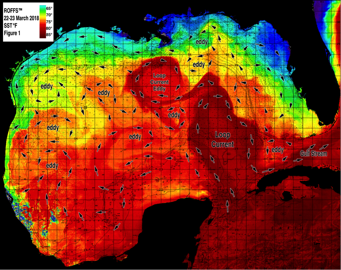
Figure 1b: Last year’s (2018) Gulf of Mexico conditions were derived from a variety of infrared sensors to get SST from NASA, NOAA, and JPSS satellites during March 22-23, 2018. Main features and surface currents are labeled.
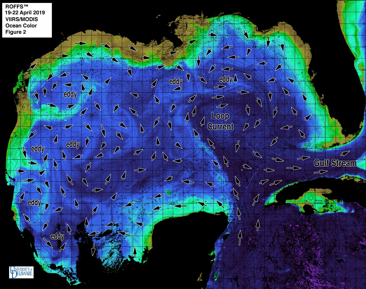
Figure 2a: This year’s Gulf of Mexico conditions derived from the ocean color/chlorophyll imagery during April 19-22, 2019 from the VIIRS sensors on SNPP satellite in combination with the Aqua and Terra sensors on the MODIS satellite provided by the University of Delaware. We consider this an image pair with the above SST Figure1a image. Same main features and surface currents labeled.
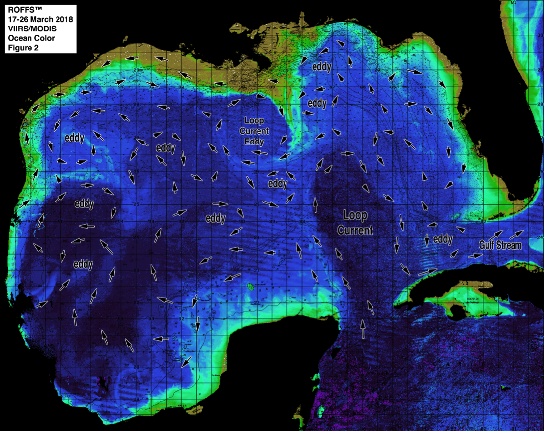
Figure 2b: Last year’s (2018) Gulf of Mexico conditions derived from the ocean color/chlorophyll imagery during March 17-26, 2018 from the VIIRS sensors on SNPP satellite in combination with the Aqua and Terra sensors on the MODIS satellite provided by the University of Delaware. We consider this an image pair with the above SST Figure1b image. Same main features and surface currents labeled.
Conclusion
Based on what we have been observing over the last several weeks, the present ocean conditions for the Gulf of Mexico region continue to look excellent with warmer water over much of the typical fishing zones within the Gulf of Mexico early this season. The presence of both the Loop Current and favorable blue water features (eddies) will continue to keep the warmer water within these fishing zones allowing the already favorable fishing conditions to continue through the summer. Overall, we think that the Gulf of Mexico conditions for spring to early summer are EXCELLENT so it is definitely time to start fishing and call ROFFS™ for the latest and greatest updates.
It is important to note that good fishing action on a daily basis is strongly linked to local, short-term (days) current conditions that concentrate the fish once the preferred habitats of the fish are in a particular region. When the water mass boundaries associated with these currents are geographically stable and favorable, i.e., persistently pushing over “good” bottom topography and/or in a favorable inshore direction, then they concentrate the baitfish and larger fish can be found foraging. This indicates that the fishing action on any given day is controlled by relatively short term (hourly to daily) and relatively small scale (1-5 mile) movements of the currents and their water mass boundaries. Our experience indicates that to reliably forecast specific concentrations of fish on a daily basis one must evaluate the ocean conditions on these scales. Relatively small subtle changes in the currents and their associated water mass boundary zones often have dramatic effects on the distribution and concentration of fish, therefore it is extremely important to monitor these conditions and the changes in them on a daily basis.
Contact ROFFS™ (321-723-5759 / fish7@roffs.com / roffs.com) for daily real-time detailed fishing forecasting analyses and get the inside track to where the better conditions will be tomorrow. We continue to monitor these Gulf of Mexico conditions and how they change from day-to-day as the larger recreational and tournament fishing season has arrived. The bottom line is GET OFFSHORE NOW, for the early season EXCELLENT fishing conditions have already started and should continue through May and into June and July.
Safe and Successful Fishing!
ROFFS™ Team
[/et_pb_text][/et_pb_column][/et_pb_row][/et_pb_section]