Please click here to view full 2021 ROFFS™ Bahamas Season Fishing Forecast as a PDF.
Bahamas Season Fishing Forecast for 2021: BAHAMAS BACK IN FISHING ACTION
By Matthew Upton
Introduction:
For 19 years ROFFS™ has been developing objective methods for forecasting the overall fishing conditions during the spring Bahamas Fishing Season from March through early June. The hypothesis for forecasting the seasonal marlin fishing action stems from the location of the blue and often warmer water that occurs from the Cat Island – San Salvador Island area and south to southeast of these islands where it is presumed that the marlin concentrate before, during and after spawning. We have been calling this water “blue marlin water” in our analyses. From satellite data, we can identify this water based on its ocean color/chlorophyll signature and sea surface temperature (SST) characteristics. Our working hypothesis and experience have shown that the marlin and other pelagic species (such as tuna, dolphin and wahoo) are associated with this water and the more “blue marlin water” that exists in the Abaco Islands and Eleuthera Island areas early in the season, the greater the relative abundance of marlin in these areas.
In recent years we have also observed an association between the “blue marlin water” and the yellowfin tuna action in the Bahamas, northward along the western side of the Gulf Stream between Jacksonville, Florida and northward towards Cape Hatteras, North Carolina. We do observe evidence that when more “blue marlin water” passes northwest of Abaco to the eastern side of the Gulf Stream that a certain unknown proportion of the migratory fish move to the western side of the Gulf Stream. This brings more fish to the coastal fisheries at the edges of the Gulf Stream water throughout the spring to early summer season from Florida to North Carolina.
Based on our observations in the Bahamas from Eleuthera to the Abacos over the last 30+ years, it appears that excellent fishing action occurs within the Bahamas areas when there is a substantial volume of the “blue marlin water” pushing over the 100-500 fathom (600-3000 feet) and shallower ledges along the eastern side of Eleuthera and the Abacos. Relatively favorable fishing seasons occur when this water only occurs over the 500-1000 fathom depths, but does not reach the 100-500 fathom or shallower depths of both areas. Mediocre to poor years occur when there is a lack of this water over these areas. However, in these cases, short pulses of this water bring fish into these areas regardless. Unless there is a sustainable flow of the water into these regions, the catch rates remain below average to average through the season. It is also important to understand that good fishing action on a daily basis is linked to the water mass boundaries created by these currents, where they are stable for consecutive days over good bottom structure and ledges and where the water is pushing in a favorable inshore direction over good structure toward the islands. These features, that have remained favorable for multiple days, concentrate the baitfish and draw bigger fish into these areas.
The hypothesis is also based on our experience using the hourly satellite observations of the ocean conditions derived by ROFFS™ (www.roffs.com), catch reports provided by a variety of sources for the past 30+ years and information derived from other sources of oceanographic data. The infrared (IR) satellite data used to observe the sea surface temperature (SST) and the ocean color/chlorophyll data are used for indices of phytoplankton (chlorophyll), water clarity, and colorized dissolved organic material (CDOM) are received from a variety of data sources including NASA, NOAA, Suomi National Polar-orbiting Partnership (SNPP or JPSS) and the European Space Agency (ESA) satellites.
Last year due to the pandemic, for the most part the Bahamas were closed down for non-resident fishing and the majority of the visiting recreational anglers/boats and charters could not fish in Bahamian waters. Therefore, we did not get many if any reports from last year. So to compare last year to this year we will strictly have to go by differences in ocean conditions, our experience and how fishing is this year so far.
[/et_pb_text][/et_pb_column][/et_pb_row][et_pb_row _builder_version=”4.6.3″ _module_preset=”default” column_structure=”1_2,1_2″][et_pb_column _builder_version=”4.6.3″ _module_preset=”default” type=”1_2″][et_pb_image _builder_version=”4.6.3″ _module_preset=”default” title_text=”2020SST” src=”https://roffs.com/wp-content/uploads/2021/03/2020SST.jpg” hover_enabled=”0″ sticky_enabled=”0″][/et_pb_image][/et_pb_column][et_pb_column _builder_version=”4.6.3″ _module_preset=”default” type=”1_2″][et_pb_image _builder_version=”4.6.3″ _module_preset=”default” title_text=”2020CHL” src=”https://roffs.com/wp-content/uploads/2021/03/2020CHL.jpg” hover_enabled=”0″ sticky_enabled=”0″][/et_pb_image][/et_pb_column][/et_pb_row][et_pb_row _builder_version=”4.6.3″ _module_preset=”default”][et_pb_column _builder_version=”4.6.3″ _module_preset=”default” type=”4_4″][et_pb_text _builder_version=”4.6.3″ _module_preset=”default” hover_enabled=”0″ sticky_enabled=”0″]Figure 1: Last years conditions were derived from a variety of infrared sensors to get SST from NASA, NOAA, and ESA’s Sentinel 3 satellites during March 10-13, 2020 and Figure 2: Derived from the ocean color/chlorophyll imagery during March 09-13, 2020 from the Sentinel 3 satellites, VIIRS sensors on SNPP satellite in combination with the Aqua and Terra sensor on the MODIS satellites provided by the University of Delaware. We consider this an image pair.
Background and Some Data for 2021
Although we have learned that the favorable oceanographic conditions develop from the presence or absence of the “blue marlin water” during the main Bahamas fishing season, we continue to prepare the annual forecast from data around mid March. These allow us insight into the conditions prior to the spring season, and understand the ongoing fishing success starting in March and continuing through June. We prefer to use real-time observations and have learned that evaluating the preseason conditions in March provides insight into future seasonal trends. We evaluate whether or not we are observing “normal” conditions or anomalies. We rely on real time satellite data but also consult climate models from some of the world experts in the field. One indication is the SST in the core of the Gulf Stream off Miami and the SST of the Bahamas “blue marlin water” east of Cat Island to east of Long Island. Because we started our forecasting studies during the first week or two of March in 2003 we have continued our time series using that same time period to directly compare each year.
The ROFFS™ 19 year (2003-2021) mean SST for the core of the Gulf Stream off Miami is 78.7°F during our standard early to mid-March measurement period. This year the SST was 78.8°F in the core of the Gulf Stream off of Miami on March 13-16 (2021), which is only about one-half a degree cooler than during the same period as the previous year (2020) and 1.3 degrees cooler than the same period in 2019 which is about right at the 19 year mean. While we have not been recording the SST of the Bahamas “blue marlin” water offshore of Cat Island to Long Island as long, the 14 year mean (2008 – 2021) SST for the warmer water east of Cat Island area is 77.0°F. This year the SST of the “blue marlin water” east of Cat Island/Long Island was 76.8°F during the standard early to mid-March time period. The water both off Cat Island and within the Gulf Stream east of Miami both slightly decreased from the previous year. Although we continue to observe this variability and no real consistent trend, the presence of the slightly cooler “blue marlin water” off Cat Island could indicate a slightly later arrival of an abundance of marlin and various tuna species into the Bahamas region compared to the last two years but within the average expected time when compared to the last 14-19 years.
Furthermore, we continue to monitor climate variability and ocean-wide circulation and consider other indices such as the North Atlantic Oscillation (NAO) and the Atlantic Multidecadal Oscillation (AMO). The NAO is the dominant mode of climate and seasonal variability in the North Atlantic region ranging from central North America to Europe and much into Northern Asia. The NAO is a large-scale variation in atmospheric mass between the subtropical high and the polar low. The corresponding index varies from year to year, but also exhibits a tendency to remain in one phase for intervals lasting several years. The NAO is a climatic phenomenon in the North Atlantic Ocean defined as the difference of atmospheric pressure at sea level between the Icelandic low and the Azores high. Through east-west oscillation motions of the Icelandic low and the Azores high, it controls the strength and direction of westerly winds, currents, and storm tracks across the North Atlantic Ocean. It appears to be one of the most important manifestations of climate fluctuations in the North Atlantic (https://www.ncdc.noaa.gov/teleconnections/nao/). This year (2021) the NAO index for January and February is significantly lower than last year (around -1.11 and 0.14) and considered normal to below normal. Typically the NAO is more important for driving the west to east winds (westerly’s) north of 30°N latitude. Lower NAO index values or a decrease in NAO index suggests less wind and more warming so we expect both the atmospheric temperature and SST to be slightly warmer on average than last year.
The Atlantic Multi-decadal Oscillation (AMO) has been identified as a coherent mode of natural variability occurring in the North Atlantic Ocean with an estimated period of nearly 100 years. It is based upon the average anomalies of sea surface temperatures (SST) in the North Atlantic basin, typically over 0°-80°N latitude. (https://climatedataguide.ucar.edu/climate-data/atlantic-multi-decadal-oscillation-amo). The unsmoothed AMO Index for January and February 2021 is approximately 0.14-0.15 which is lower than the last two years suggesting decreased SST anomalies but still a positive AMO. We have learned that the current positive trend in these indices suggest a decrease in speeds of the North Atlantic Ocean Circulation is occurring. This includes a slow decrease in current speeds of the Gulf Stream system, which we have noticed over the years. Also, a positive AMO is usually associated with an increase in the number of tropical storms that mature into hurricanes because the overall North Atlantic Ocean SST is higher. This does not take into account the wind shear variability and other aspects of tropical storm genesis. For easy to understand answers to frequently asked questions about the AMO see http://www.aoml.noaa.gov/phod/amo_faq.php#faq_2.
Regarding El Niño we have yet to see or read about any direct relationship between El Niño – La Niña and the Southern Oscillation (ENSO) and the oceanographic conditions in the Bahamas area. Currently we are in a La Niña phase that will likely transition to an ENSO-Neutral stage during the next 3 months (https://www.cpc.ncep.noaa.gov/products/analysis_monitoring/lanina/enso_evolution-status-fcsts-web.pdf).
Nowcast Analysis
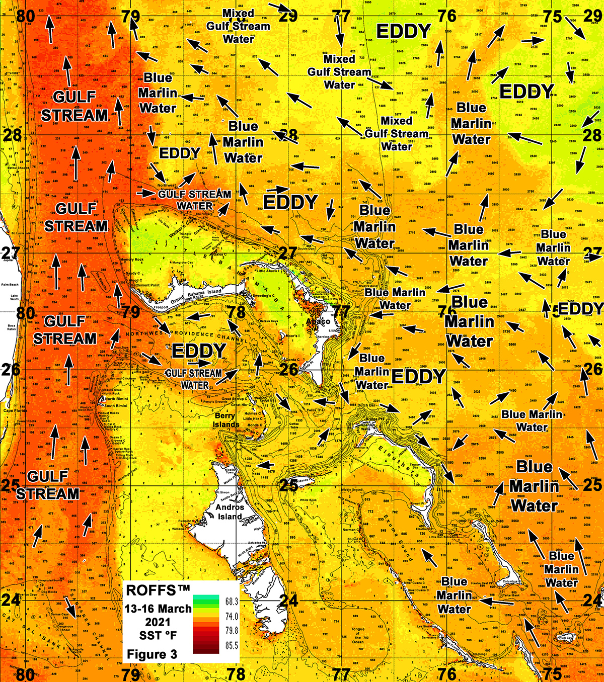
In this section we want to discuss and present the current oceanographic conditions (Figure 3 and Figure 4) and compare it briefly to last years conditions (Figure 1 and 2). For clarification purposes Figures 1 and 3 were derived from a variety of NASA, NOAA, ESA, and JPSS satellites during the mid-March (March 13-16) period and Figures 2 and 4 were derived from the SNPP, VIIRS, Sentinel 3, and NASA MODIS Aqua/Terra ocean color/chlorophyll imagery during relatively same mid-March time period (March 12-16). We also stay consistent with our color palettes through the years to make it easier to directly compare the conditions by satellite signature.
In both instances, we could not use single and same day imagery for the SST and ocean color data due to cloud cover interference, so we used a combination of imagery and the ROFFS™ cloud reduction techniques to produce these relatively cloud-free images. However, for comparison purposes we consider these images as an equal image pair for the purposes of this discussion. While these provide a visualization of the March conditions, they also provide examples of how the eddy features, or lack of eddy features, and the water circulation are pulling the “blue marlin water” through the Bahamas. This is important for understanding the dynamics of the region. Both images for each year have the same arrows, eddy and “blue marlin water” labeling. The flow of the water was derived from our ROFFS™ sequential image analysis of Lagrangian coherent features where we study several days of satellite imagery to follow the signature water masses and their motion. An example of this years SST satellite infrared imagery can be found on the ROFFS™ YouTube site at (https://www.youtube.com/watch?v=T0t6pTX8uxc) showing the flow of the water around the Bahamas region during the last two months, where the darker grey water represents the warmer water. Another example of the same imagery loop with a more close up view of the Bahamas can also be found on the ROFFS™ YouTube site at (https://www.youtube.com/watch?v=AavBTwdwi98).
This year (Figure 3 and 4) we notice the greater than normal abundance of “blue marlin water” that is east of Long Island, Cat Island, Eleuthera and Abaco Islands. This is especially evident in the ocean color/chlorophyll image (Figure 4). In fact, this abundance of “blue marlin water” has already moved up north of Abaco and northwest toward the Gulf Stream and has already interacted with the Gulf Stream waters reminiscent of 2018. The large abundance of “blue marlin water” already interacting with the Gulf Stream indicates that the first pulse of marlin and tuna populations have already arrived in the Northern Bahamas region and perhaps an earlier than normal arrival of these species further north along the coast of Florida, Georgia, and South Carolina. We have already had reports of yellowfin tuna caught off of North Carolina.
[/et_pb_text][/et_pb_column][/et_pb_row][et_pb_row _builder_version=”4.6.3″ _module_preset=”default” column_structure=”1_2,1_2″][et_pb_column _builder_version=”4.6.3″ _module_preset=”default” type=”1_2″][et_pb_image _builder_version=”4.6.3″ _module_preset=”default” title_text=”13-16MarchBahamasSSTWeb1200px” src=”https://roffs.com/wp-content/uploads/2021/03/13-16MarchBahamasSSTWeb1200px.jpg” hover_enabled=”0″ sticky_enabled=”0″][/et_pb_image][/et_pb_column][et_pb_column _builder_version=”4.6.3″ _module_preset=”default” type=”1_2″][et_pb_image _builder_version=”4.6.3″ _module_preset=”default” title_text=”12-16MarchBahamasCHLWeb1200px” src=”https://roffs.com/wp-content/uploads/2021/03/12-16MarchBahamasCHLWeb1200px.jpg” hover_enabled=”0″ sticky_enabled=”0″][/et_pb_image][/et_pb_column][/et_pb_row][et_pb_row _builder_version=”4.6.3″ _module_preset=”default”][et_pb_column _builder_version=”4.6.3″ _module_preset=”default” type=”4_4″][et_pb_text _builder_version=”4.6.3″ _module_preset=”default” hover_enabled=”0″ sticky_enabled=”0″]Figure 3: This years conditions were derived from a variety of infrared sensors to get SST from NASA, NOAA, and ESA’s Sentinel 3 satellites during March 13-16, 2021 and Figure 4: Derived from the ocean color/chlorophyll imagery during March 12-16, 2021 from the ESA Sentinel 3 satellites, VIIRS sensors on SNPP satellite in combination with the Aqua and Terra sensor on the MODIS satellites provided by the University of Delaware. We consider this an image pair.
It appears that two main eddies are responsible for the larger amount of “blue marlin water” moving into the eastern and northern Bahamas areas; one counter clockwise rotating eddy directly northeast of Eleuthera centered at 76°15’W & 26°00’N and a larger clockwise rotating eddy way offshore of Abaco centered east of 75°00’W between 26°00’N and 27°00’N. There is also another clockwise rotating eddy centered east of San Salvador that is aiding in pulling the large amounts of slightly warmer darker “blue marlin water” water directly offshore of these eastern and northern Bahamas Islands. If these eddies remain relatively stable and do not vary much in location over the next few weeks to month it will continue to push favorable “blue marlin water” directly toward the Islands and northwest into the Gulf Stream making conditions very favorable. In fact, the overall flow of “blue marlin water” already appears to be very favorable for fishing action off of Cat Island to east of Eleuthera east of Abaco coming up from the southeast and pushing northwest directly into Little Abaco Canyon and Great Abaco Canyon and into the Gulf Stream. We have already had evidence of some marlin action and good wahoo action associated with this water east of Abaco and north of Walker’s Cay.
Even though the SST is slightly cooler than the last couple of years it is still within the 15-20 year mean. Therefore, we think the more important factor of the arrival of the larger populations of tunas and marlin this year is the larger amount of “blue marlin water” in this area and closer to the Islands. We even see evidence of pathways of this more productive water toward Berry Islands from the east and into Exuma Sound from south of Cat Island. If the wind and water is pushing into the Pocket south and southwest of Chub Cay, it can produce very good fishing action for the upcoming tournaments.
North of Walker’s Cay there is a smaller counter-clockwise rotating eddy and north of Little Abaco there is a clockwise rotating eddy that is keeping the “blue marlin water” a bit north. However, there are still good conditions where the “blue marlin water” is interacting against the Gulf Stream water creating favorable conditions for fishing action along these convergence zones. Evidence of that is the recent blue marlin and tuna bites north of Walkers and Matanilla Shoals area the past week or two. Overall, there appears to be more eddies in the Bahamas offshore areas than the previous two years. We have also observed the traditional counter-clockwise flow in the Northwest Providence Channel pulling in mixed Gulf Stream water. It is the stronger western eddy edges south of Freeport pushing into western Tuna Canyon that has looked favorable for over a week now.
As the water warms in the coming weeks we anticipate that a substantially higher amount of marlin, tuna and other species will continue to be moved closer to the Bahamas Islands especially with the already large amounts of “blue marlin water” occurring in these areas providing better fishing action compared to the pervious two years. These present conditions are considered excellent pre-season conditions, which is promising. ROFFS™ will be monitoring these and other conditions that develop over the next several weeks and months as we do in other areas.
Seasonal Concluding Thoughts
Based on what we have been observing in March, the present ocean conditions for marlin, yellowfin and blackfin tuna, wahoo and dolphin action in the Bahamas region, particularly in the eastern and northern Bahamas, look very good. Compared to last year, the conditions this March appear more favorable for early fishing action due to the fact there is already a much larger than normal amount of “blue marlin water” in this area and closer to the island coastlines. Furthermore, fishing action has the potential to get better for the mid-spring to late spring time periods as the SST is at the average temperature for this time of year and cooler than the previous two years and will continue to warm and be closer to the preferred habitat of these popular targeted pelagic species. The current ocean conditions in the Bahamas suggest that the larger influx of blue marlin, yellowfin tuna and other pelagics may be normal to slightly earlier this year compared to last year. We will continue monitoring these developments as the season progresses and please contact ROFFS™ for more details. With this exciting amount of “blue marlin water” so close to many of the Islands and pushing in a favorable inshore direction and over good structure, this may be one of the better years for marlin fishing in the Bahamas, particularly off of Abaco, Cat Island and Eleuthera.
In conclusion, it is important to note that good fishing action on a daily basis is strongly linked to local, short-term (24-48 hours) current conditions that concentrate the fish once the preferred habitat of the fish are in a particular region. When the water mass boundaries of these currents are stable and favorable, i.e., continuously pushing over good bottom topography such as the Northeast Humps, The Pocket, Hole in the Wall, Tuna Canyon, Wonderland, or Little Abaco Canyon, then they concentrate the baitfish and larger fish can be found foraging. This means that the fishing action on any given day is controlled by hourly to daily and relatively small-scale (1-10 mile) movements of the currents and their water mass boundaries. Our experience indicates that to reliably forecast specific concentrations of fish on a daily basis, one must evaluate the ocean conditions on these scales. Relatively small subtle changes in the currents and their boundaries often have dramatic effects on the distribution and concentration of fish. Contact ROFFS™ for these daily detailed fishing forecasting analyses and get the inside track to where the better conditions are tomorrow. If you are able, we suggest you prepare now for the spring Bahamas fishing season and other fun fishing action as the good fishing conditions in the Bahamas region has already started.
Please continue to stay safe and tuned in to ROFFS™ on our web site www.roffs.com or on Facebook/Instagram @roffsfishing for the next few weeks for additional discussions related to marlin, tunas, mahi, wahoo, and sailfish and the oceanographic conditions and seasonal fishing forecasting off the United States east coast and in the Gulf of Mexico area.
Safe and Successful Fishing from ROFFS™
[/et_pb_text][/et_pb_column][/et_pb_row][/et_pb_section]