Please click here to view full 2021 ROFFS™ North Season Fishing Forecast as a PDF.
Northeast U.S. Season Preview 2021: COOL START AGAIN THIS YEAR BUT CONDITIONS ARE IMPROVING RAPIDLY
By: Matthew A. Upton
ROFFS™ concludes its 2021 spring preview series by providing an overall update of the oceanographic conditions from mid-May offshore of the northeastern United States focusing in on the Mid-Atlantic Bight region and its canyons that includes the zone from Cape Hatteras to Georges Bank into the Gulf of Maine. We again utilized a combination of many different data sets mainly satellite derived sea surface temperature (SST) and ocean color/chlorophyll images. In this edition we will discuss the present ocean conditions and what it means for the upcoming late-spring to summer fishing season for the Cape Hatteras, NC to Massachusetts offshore canyon areas.
As a reminder, for forecasting short-term oceanographic conditions related to finding fish, ROFFS™ uses real-time direct observations. We have learned that evaluating the preseason conditions along with regional, downscaled climate models provides insight into future seasonal trends for fishing. Experience and understanding the ocean – atmospheric dynamics is our guide as we have had moderate success in forecasting seasonal trends of fishing productivity based on the stepwise progression in the location of the fishes’ preferred habitat based on temperature and water color. Please reference our 2021 Bahamas forecast for more in-depth discussion on the environmental and climate indicators that goes into our detailed evaluation of the eastern United States fishing forecasting analysis (Click Here).
Background and Some Observations for 2021
It is important to look at the year-to-year trends including the anomalies to gain insight into the location and condition of the fishes’ preferred habitat compared with previous years. Comparing similar locations and features to last year during the same general time period in mid-May we found that the SST of the core of the Gulf Stream off of Cape Hatteras, NC for 2020 was approximately 80.5°F to 81.2°F and for this year it is about 1.0°F cooler (79.5°F to 80.4°F) similar to 2019. The SST of the coastal water off of New Jersey, Delaware and Maryland is approximately 5.0°F to 6.0°F warmer this year than during the same time period in 2020 also similar but a bit warmer than 2019. Furthermore, the SST offshore of Long Island is about 4.0°F to 5.0°F warmer than this time last year. These and other indicators that will be described below suggest a normal to slightly early arrival of tuna, wahoo, dolphin and billfish into the Gulf Stream section of the northeast U.S. region this year compared to last year, but also a normal to slightly earlier arrival of the main population of tuna, wahoo, dolphin and billfish to the northern canyon regions. However, it has been a slower than normal start to the tuna season from Virginia north according to many reports. In fact, the SST’s were all about three to four degrees cooler inshore until the past week-to-ten days as the atmospheric temperatures are finally increasing. Part of this slower than normal start to the tuna season up north is due to the similar cooler overall weather pattern and higher winds for the spring season from North Carolina and north like last year, but it is starting to heat up now. With that said, with June approaching and forecasts for warmer temperatures, waters (especially inshore) will be starting to warm at an average rate of 0.5°F to 1.0°F per day or more triggering tuna, dolphin, wahoo and some billfish to start migrating north soon, especially within the main eddy features that are connected to the Gulf Stream and we will be discussing within this forecast.
One driver for trends and weather and for the spring SST’s in the Northeast U.S. region can be attributed to the North Atlantic Oscillation (NAO) and its positive phase during the months of February and March but switching to a negative phase in April. NAO index is based on the atmospheric surface sea level pressure difference between the Subtropical (Azores) High and the Subpolar Low within the North Atlantic Ocean (https://www.ncdc.noaa.gov/teleconnections/nao/). Typically, positive NAO phases means higher winds, cooler SST and atmospheric temperatures, but currently there was a switch to a negative phase in April which could mean a warming period and less winds in May and June which is encouraging for warming the SST and calmer winds that lead to relatively favorable fishing conditions and easier access offshore. Another possible factor to consider is the El Niño phase in the Pacific Ocean. Currently we are at the end of a La Niña phase and it is forecasted by NOAA to transition to a ENSO neutral phase through the summer, which usually means normal to below normal SST’s in the Gulf of Mexico, Caribbean and east to northeast Pacific, but it remains to be seen what that means for waters offshore of the Northeastern U.S.
Also, please see ROFFS™ recent Southeast U.S. Gulf Stream fishing conditions analysis (Click here). These Gulf Stream conditions to the south are usually a good indicator and associated with the main populations of mahi, yellowfin tuna and marlin along with other highly migratory species migrating north during the spring months. Reports from mid-April to mid-May have already indicated good dolphin and tuna action along both sides for the Gulf Stream edges from Florida to North Carolina and they are already catching marlin off of North Carolina to the Cape Hatteras area. Based on historical observations we anticipate that these fish along with other tuna, mahi-mahi, wahoo and then billfish will continue and already have moved to the northeast U.S. regions from the Gulf Stream and then into the spin off warm core large eddy features from the Gulf Stream that move over the canyon areas. Additional good news is that marlin have already been spotted and caught off of South Carolina and North Carolina along with plenty of yellowfin tuna and dolphin out of Oregon Inlet and Cape Hatteras area to the Point which is about normal to perhaps a bit sooner than most years during this time period.
Nowcast Analysis
One of the most valuable features that we look at when trying to forecast the region in the Northeast U.S. is the number, size and location of clockwise rotating warm core Gulf Stream eddies that are located north of the Gulf Stream region from south of Georges Bank to offshore of New York, New Jersey to Delaware areas. These are eddies that have broken off from the Gulf Stream and tend to slowly drift westward toward the Atlantis Canyons to Hudson Canyon and then in a southwestward direction toward the Norfolk Canyon before being pulled back into the Gulf Stream. The environment associated with warmer usually blue water (below the surface) and the strong boundaries of the eddy feature outer edges provide valuable habitat for the highly migratory large pelagic fish that enter this region in the spring and early summer seasons. This year already appears to be much more encouraging than last year at this time with larger number of warm-core Gulf Stream eddies in better positions that this year. The SST this year started in April and early May to look more like the cooler trend we saw in 2020, but conditions are starting to heat up and look much more promising in the past two weeks.
The recent spring satellite data shown in Figure 1 and 2, and the fishing reports we have already received may provide insight into the upcoming fishing season. Figure 1 was derived from a variety of U.S. (NOAA and NASA) and European (ESA) satellites to show the SST during May 16-18, 2021 period. Figure 2 was derived from the NASA MODIS ocean color satellites (Aqua and Terra) and ESA’s Sentinel 3A and 3B satellites along with SNPP VIIRS satellite showing the ocean color/chlorophyll image data during this same period May 15-18, 2021.
We used a combination of imagery over a few days with the time-tested ROFFS™ cloud reduction algorithm to produce these relatively cloud-free images over this entire area. The time of the satellite passes and the amount of data taken from each image is not the same for the SST and ocean color images. Thus, there are some subtle differences in locations of where the water mass boundaries derived from the SST and chlorophyll/ocean color occurs. In spite of these small discrepancies this image pair is considered more than adequate for the purposes of our seasonal discussion.
The directional flow of the water was derived from our ROFFS™ sequential image analysis techniques, following the water masses, image to image based on the water mass’s distinct, i.e. signature value. An example of this year’s SST satellite infrared imagery in a greytone movie can be found on the ROFFS™ YouTube™ site (https://www.youtube.com/watch?v=KYSBvAYrrUo). Viewing the movie several times allows one to visualize the flow of the Gulf Stream and other currents, where the darker greytoned water is the warmer water and white areas are clouds. Notice the progression of these larger warm-core Gulf Stream eddies from east to west then southwest between the Gulf Stream and Canyon and bank regions.
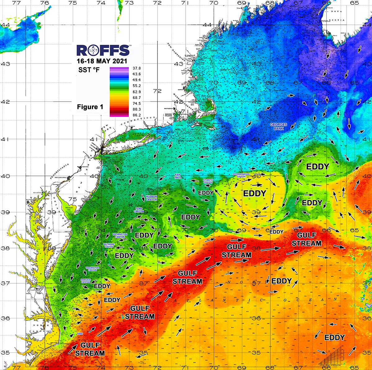
Figure 1: This year’s Northeast U.S. conditions were derived from a variety of infrared sensors to get SST from NASA, NOAA and ESA satellites during May 16-18, 2021. Main eddy features, canyons and surface currents are labeled.
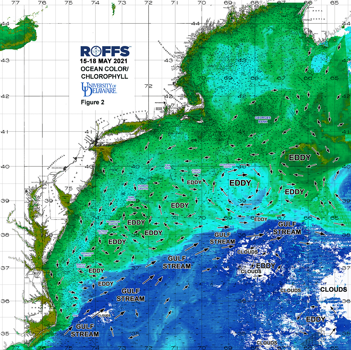
Figure 2: This year’s Northeast U.S. conditions derived from the ocean color/chlorophyll imagery during May 15-18, 2021 from the Aqua and Terra sensors on the MODIS satellite provided by the University of Delaware and from Sentinel 3A & 3B ESA satellites along with SNPP VIIRS satellite data. We consider this an image pair with the above SST Figure 1 image. Same main eddy features and surface currents labeled, white indicates clouds.
Looking at Figure 1, the most important features to highlight are four eddy systems. The first and most important to keep an eye on is the largest warmest clockwise rotating warm-core Gulf Stream eddy centered near 68°30’W & 39°30’N south of Hydrographer to Oceanographer Canyon that is pushing warmer and cleaner bluer 67°F to 68°F water into the 100-1000 fathom curves over the bank into Veatch, Hydrographer and Oceanographer Canyon for what has to be some good early season tuna action. As you look along the southern edges of this eddy it is directly interacting and pulling up newer Gulf Stream water within the eddy so mahi, wahoo and billfish will be soon to follow. As this main large eddy continues to move west, we expect conditions to improve over Atlantis Canyons by end-of-May, early June, and over the Fish Tails to Hudson Canyon by mid-to-late June and likely anglers will be fishing these productive eddy waters in late June and July between Toms and Baltimore Canyon. Furthermore, there is another clockwise rotating eddy system positioned a bit farther south of the bank, south of West Atlantis Canyon and the Fish Tails centered near 71°00’W & 38°45’N that is also close and interacting with the Gulf Stream pulling up some 62°F to 65°F water toward the offshore Hudson and Block Canyon area for some promising tuna action in that area soon. This eddy should also continue to drift west and could improve conditions over Hudson and Toms Canyon in the next few weeks, if this eddy is not disrupted or sucked up by the Gulf Stream directly south of it. Last of all, there are a pair of eddies, one rotating counter-clockwise centered east of Poor Mans Canyon near 73°15’W & 37°50’N, and the other a warm-core Gulf Stream clockwise rotating eddy centered east of Spencer and Wilmington Canyon near 72°30’W & 38°25’N. These eddies have produced bluefin tuna action in early April up near Hudson Canyon and are promising features that are currently pulling up and holding some indirect and older Gulf Stream 60°F to 61°F water over the Lindenkohl, Spencer, Wilmington and Baltimore Canyon area, with related filaments down over Poor Mans to Washington Canyon for some chances at early season tuna, swordfish and shark action.
Looking at these four aforementioned eddies, as the SST warms these conditions over the Mid-Atlantic Canyons are expected to improve over the next few weeks as these eddies further interact with the Gulf Stream and pull in more productive waters in the near future. As these eddies progress westward and then southwestward they will continue to provide good fishing conditions for the canyons south of Massachusetts to south of New York and also the Canyons between Hudson and Norfolk Canyons into June and July. Keep in mind that the Gulf Stream is the driving force to the south of these Canyon regions and it only takes a few days to a week for the Gulf Stream to meander farther north and directly interact with these eddies or shed another warm core eddy to improve the conditions in the Northeast U.S. and we already know there are tuna, marlin and mahi-mahi within the Gulf Stream region outside of North Carolina. Conditions over the past two to three weeks from off of Washington Canyon to offshore of Norfolk Canyon south to the Point has also looked promising with a few smaller eddies that have pushed in some Gulf Stream related blue-green to bluer 65°F-70°F-72°F water for some decent tuna conditions over the bank and in the outer canyon regions.
It is also important to look further east to the eddies and conditions forming east of the Oceanographer Canyons and southeast Georges Bank. As these will likely be the features that contribute and progress west then southwest and what anglers will be targeting during the mid-to-late summer season and bigger tournament season from over the canyons south of New York to the canyons offshore of New Jersey, Delaware, Maryland and Virginia. At this time we notice another warm core-core Gulf Stream clockwise rotating eddy centered near 66’30’W & 40°15’N southwest of Georges Bank and another large direct Gulf Stream meander to the southwest of that eddy for some encouraging features to watch over the course of the next few months. Furthermore, in the next few weeks to month, the SST will continue to warm closer the bank providing opportunities for tuna, wahoo, dolphin and marlin to migrate farther north into the canyon areas and inshore for easier targets. Furthermore, it is interesting that within the Gulf of Maine and Georges Bank region, the eastern part of the Gulf of Maine including Georges Bank looks significantly cooler this year than last year, while the western Gulf of Maine closer to the U.S. coast looks just slightly warmer, this could indicate a slightly later arrival of tuna in the Gulf of Maine than last year.
Looking at Figure 2, we are not concerned about the lack of bluer water over this region at this time because we are at the peak season of the spring algae bloom (as evident in the large abundance of greener water offshore within the eddies). This is an annual event that provides the food for many of the baitfish species for the next month or two. However, just because the surface water is greener in color within these offshore eddies a few feet below the surface the water is likely clearer and bluer. It is neat to see how the offshore warmer water is green, but some of the cooler inshore water over the bank and between 30-100 fathoms is blue-green. The ocean color/chlorophyll signature becomes much more important later in the summer to distinguish the main water mass boundaries when the SST is so warm and uniform.
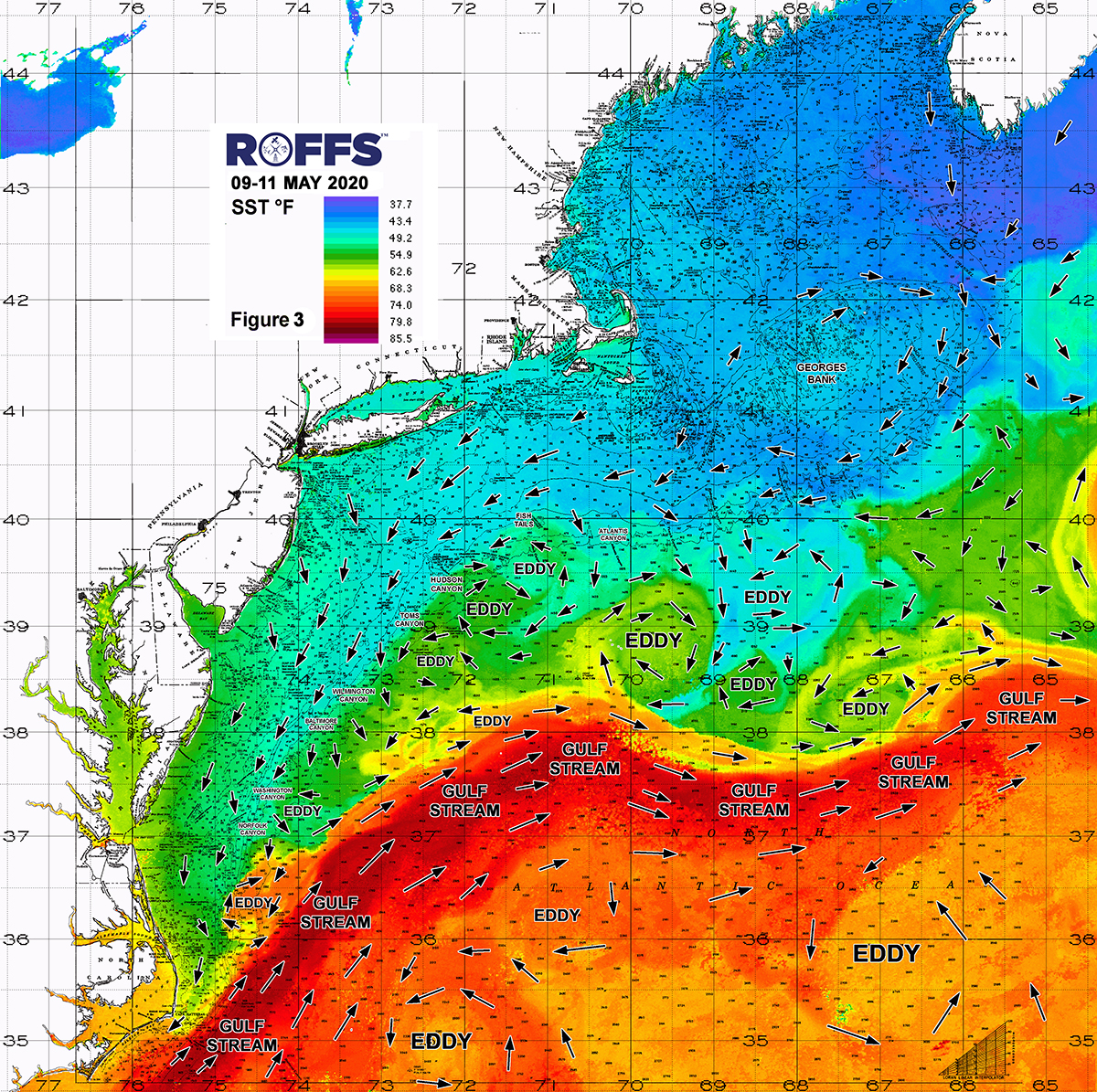
Figure 3. Last year’s Northeast U.S. conditions were derived from a variety of infrared sensors to get SST from NASA, NOAA and ESA satellites during May 09-11, 2020. Main eddy features, canyons and surface currents are labeled.
Another indicator of this year’s spring to early summer fishing season is the orientation of the Gulf Stream. If you look at the location of the Gulf Stream in comparison to last year’s SST conditions (Figure 3) and compare it to this year’s conditions (Figure 1), you can see the Gulf Stream this year appears to be farther offshore (southeast) west of 70°00’W than last year, but farther north when you get east of 70°00’W, indicating a closer source of fish closer to the western canyons last year than this year, but a closer source of warmer water and fish for the eastern canyons than last year.
Another effective indicator for forecasting a good 2021 season is the recent fishing reports. They have already caught an abundance of mahi and yellowfin tuna off of North Carolina to the Point and out of Virginia area and some billfish have been caught the past couple of weeks off of North Carolina in the Gulf Stream waters. This indicates that the first wave of target species have already arrived and are within the Gulf Stream and it only takes a push north and a pathway farther inshore within these eddy features and as the SST warms. There should be at least tuna in many of the canyon regions by the end of May and early June. In fact, we know from reports that there have been bluefin tuna caught inshore just east of northern New Jersey and New York and in the Hudson Canyon area the past few weeks, so bluefin tuna and likely bigeye tuna are in and around many of the canyon regions already, it just takes a good weather break to get out there and fish.
Conclusion
Based on what we have been observing over the last few weeks with the nice batch of Gulf Stream warm-core eddy features in the Northeast U.S. and the location of the Gulf Stream, it appears that the arrival of the larger populations of tuna, wahoo, mahi-mahi, and billfish may arrive at the normal time and earlier than last year as the SST is warmer overall in many regions and the eddies so far are closer to the bank. Compared to last year, the SST (other than the Gulf Stream) is warmer which tells us it is going to be an earlier arrival of most pelagic target species compared to last year including the main migration of tuna and marlin a few weeks earlier than the past couple of years. It remains to be seen how many bigeye will arrive this year, as this is still a mystery over the last few years. We still have so much to learn about the distribution and migrations of these and other fish and their association with different oceanographic conditions. Bigeye tuna tend to stay deeper in water column and are many times associated with pilot wales and come into the canyon areas early in the morning or early evening to feed then go back offshore. This is one trend we continue to monitor. Yellowfin tuna is another mystery most years, as usually the best yellowfin action is during late May and June then becomes scattered and then becomes better again in mid-to-late September and early October. The GOOD NEWS is this year with the warmer to normal SST conditions that the yellowfin tuna action may be arriving soon into the canyon regions if the eddies hold up and keeps interacting with the Gulf Stream. Overall, there are more promising eddies and trends this year than last year and the ocean conditions appear better than 2019 as well.
We encourage you to take a look at these early season conditions and if you have not done so already, get your boat ready and get offshore when the weather permits and the SST warms in the next few weeks as we know there are at least bluefin tuna in the area even in the cooler inshore waters. The bottom line is conditions look better this May than the past two years and the existing oceanographic conditions and fishing reports suggest, especially for the North Carolina and Virginia crowd, that you should already have boats in the water and fishing if you are able to do so. For the Massachusetts to New York to New Jersey, Delaware, and Maryland crowd, you should be in final preparations to try to get offshore when the weather permits and as the water is going to warm inshore and offshore and conditions will continue to improve rapidly especially for swordfish, sharks and tuna and soon to be mahi then wahoo and billfish into Memorial Day and early June.
It is important to remember that good fishing action on a daily basis is strongly linked to local, short-term (days) current conditions that concentrate the fish once the preferred habitats of the fish are in a particular region. When the water mass boundaries associated with these currents are geographically stable and favorable, i.e., persistently pushing over “good” bottom topography and/or in a favorable inshore direction, then they concentrate the baitfish and larger fish can be found foraging. This indicates that the fishing action on any given day is controlled by relatively short-term (hourly to daily) and relatively small-scale (5-10 mile) movements of the currents and their water mass boundaries. Our experience indicates that to reliably forecast specific concentrations of fish on a daily basis one must evaluate the ocean conditions on these scales. Relatively small subtle changes in the currents and their associated water mass boundary zones often have dramatic effects on the distribution and concentration of fish.
Contact ROFFS™ (1-321-723-5759 / fishing@roffs.com / www.roffs.com, @roffsfishing on Facebook and Instagram) for the up-to-date detailed fishing conditions and get the inside track to where the better fishing locations will be tomorrow. Our experienced satellite and fishery oceanographers will continue to monitor the northeast U.S. oceanographic conditions closely as the tuna season quickly improves and the active summer fun fishing and tournament season rapidly approaches. Get your boat ready now, as tuna conditions are improving rapidly especially in the Atlantis, Veatch and Hydrographer Canyon area. Thank you for your support.
Safe and Healthy Fishing!
ROFFS™ Team