Please click here to view full 2022 ROFFS™ South Season Fishing Forecast as a PDF.
Southern Florida to Cape Hatteras Spring Season Preview 2022: UPDATE ON U.S. EAST COAST GULF STREAM CONDITIONS
By ROFFS™ | James L. W. King
ROFFS™ continues its spring preview series by providing an overall update of the oceanographic conditions during early April for the east coast of the United States from the Florida Keys north to Cape Hatteras, NC including the entire offshore Gulf Stream region. As always, we have used a combination of many different data sets, but mainly sea surface temperature (SST) and ocean color/chlorophyll images. We will discuss these overall ocean conditions for the present spring season and how these conditions may translate to the near future fishing season.
For forecasting short-term oceanographic conditions related to finding fish, ROFFS™ uses real-time direct observations rather than unproven ocean models and longer-term composites. We have learned that evaluating the pre-season conditions, along with regional climate models, provides insight into future seasonal trends for fishing. Experience and understanding of the ocean – atmospheric dynamics is our guide as we have had moderate success in forecasting seasonal trends of fishing productivity based on the stepwise progression in the location of the fishes’ preferred habitat, based on temperature and water color. Please reference our 2022 Bahamas forecast for more in-depth discussion on the environmental and climate indicators that goes into our detailed evaluation of the southeastern United States fishing forecasting analysis (Click Here).
Background and Some Observations for 2022
It is important to look at the year-to-year trends including the anomalies to gain insight into the location and condition of the fishes’ preferred habitat compared with previous years. Comparing similar locations and features to last year during the same early April time period we found that the SST of the core of the Gulf Stream off of the Florida Keys to Miami, FL for 2022 was approximately 0.8-1.0°F warmer (at 81.3°F) compared to 80.3°F-80.5°F in 2021. We continue to observe similar unstable conditions to last year along the eastern edges of the Gulf Stream north of the Bahamas. This has placed the eastern side of the Gulf Stream approximately 85 miles east of Cape Canaveral versus 80-100 miles to the east in spring 2021. Offshore of Jacksonville, FL the SST of the core of the Gulf Stream appears to be 1.0°F warmer, at approximately 80.1°F, than in 2021 at 79.1°F.
Continuing north, the SST from Charleston, SC to Cape Hatteras within the core of the Gulf Stream was also warmer this year by approximately 0.5°F-0.7°F (at 79.4°F-80.1°F) than in 2021 (approximately 78.9°F-79.4°F). Additionally, we continue to observe the relatively large Gulf Stream eddy formations south of Cape Fear to Cape Lookout that was present in 2020 and 2021. This has pushed the core of the Gulf Stream further offshore from mid-February through March and early April. Unlike previous years, these eddy formations have pulled much cooler (71°F-72°F) water offshore in 200 fathom depths compared to 2020 and 2021 (74°F-75°F). Additionally, the western edges of the Gulf Stream moved back towards the 100 fathom ledge with warmer (77°F-78°F) eddy filament water south of Cape Lookout. Cooler (74°F-75°F) eddy filament water has been observed inshore to the south of Cape Lookout in 2022 with relatively stable Gulf Stream edges approaching Cape Hatteras.
Overall, these early April 2022 offshore oceanographic conditions for the southeastern United States have been markedly different than last year. Including the Gulf Stream, the majority of offshore SST along the Southeast United States has been warmer than the previous year. However, we have also observed cooler conditions well offshore to the south of Cape Fear and Cape Lookout. Overall inshore SST has also been warmer compared to 2021 with bodies of higher SST water being found closer to shore from Cape Canaveral to Cape Hatteras. Despite the SST conditions along the eastern edges of the Gulf Stream heading north of the Bahamas being similar to 2021, the lack of a large abundance of “blue marlin water” interacting with the Gulf Stream indicates that there will likely be less of the main marlin and tuna populations in the northern Bahamas region and potentially a later than normal arrival of the majority of these species further north along the coast of Florida, Georgia, and South Carolina. With that in mind, we have just started receiving reports of yellowfin tuna along the eastern side of the Gulf Stream north of the Bahamas. Additionally, we have received earlier reports of a few blue marlins and better dolphin fishing action north/northwest of Walker’s Cay and the Matanilla Shoals along the eastern side of the Gulf Stream throughout March. Otherwise, there have been relatively slow reports of sailfish action in the Florida Keys in late March and the beginning of April until this past 4-5 days as sailfish action in South Florida and upper Keys has gotten much better with the last cold front moving through. We have also noticed moderate kingfish action off central Florida, and moderate wahoo action moving into Georgia and South Carolina with some larger wahoo caught this year than previous years during this spring thus far, but wahoo action has been hit or miss. Click here for the ROFFS™ review of the Bahamas conditions.
Nowcast Analysis
The Gulf Stream Current, including its related eddies and filaments along the current’s eastern and western side are the preferred habitat of the highly migratory species for this time of year and are the most important conditions that we are studying. It is the day-to-day and hour-to-hour movements of these Gulf Stream related features that are important to monitor when deciding where to fish on a daily basis. Although we are only showing a two-to-three-day snap shot of the conditions in this report from early April (Figure 1a/b and 2a/b), we can discuss briefly the trends we see based on these early spring oceanographic conditions and related fishing reports that may provide insight into the near-future fishing season.
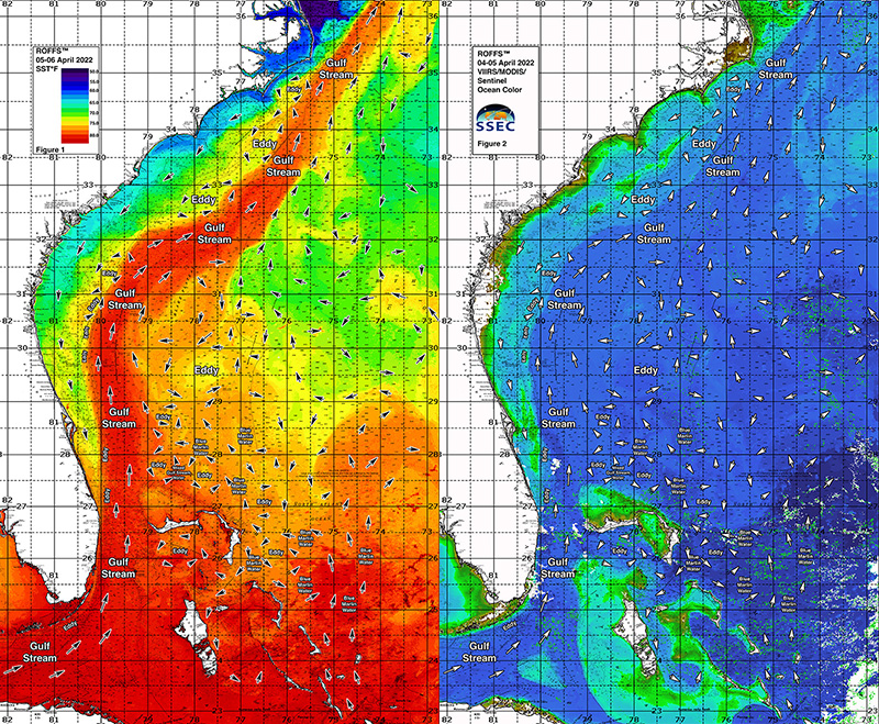
Figures 1a/b were derived from a variety of U.S. and European satellites during the early April (April 05-06, 2022 and April 05-06, 2021) period and Figures 2a/b were derived from U.S. SNPP VIIRS, Aqua/Terra MODIS Ocean color/chlorophyll, and European Space Agency’s Sentinel 3 imagery during this same period (April 05-06, 2022 and April 05-06, 2021). As the exact values of the original data from different satellite sensors (VIIRS and MODIS) are not the same, we cross-calibrated the data to derive images that have validated and consistent watercolor. This is one of the many techniques that we derived during the valuable NASA Earth Science Program projects that ROFFS™ has been involved with through the years. We cannot over-stress the importance of NASA’s Earth Science Program and the NASA, NOAA and ESA satellites for helping to understand the ocean’s dynamic ecosystem and how it impacts food security, homeland security and land-ocean interactions.
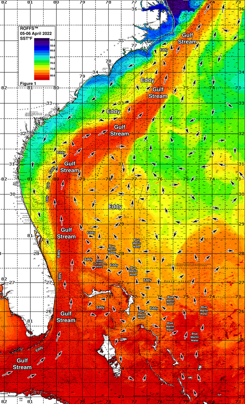
Figure 1a: This year’s Florida Keys to Cape Hatteras, NC conditions were derived from a variety of infrared sensors to get SST from NASA, NOAA, JPSS and ESA satellites during April 05-06, 2022. Main features and surface currents are labeled.
[/et_pb_text][/et_pb_column][et_pb_column type=”1_2″ _builder_version=”4.6.3″ _module_preset=”default”][et_pb_text _builder_version=”4.6.3″ _module_preset=”default” hover_enabled=”0″ sticky_enabled=”0″ admin_label=”2021 SST”]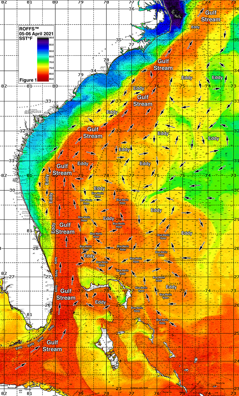
Figure 1b: Last year’s Florida Keys to Cape Hatteras, NC conditions were derived from a variety of infrared sensors to get SST from NASA, NOAA, JPSS and ESA satellites during April 05-06, 2021. Main features and surface currents are labeled.
[/et_pb_text][/et_pb_column][/et_pb_row][et_pb_row column_structure=”1_2,1_2″ _builder_version=”4.6.3″ _module_preset=”default” admin_label=”CHL Images”][et_pb_column type=”1_2″ _builder_version=”4.6.3″ _module_preset=”default”][et_pb_text _builder_version=”4.6.3″ _module_preset=”default” hover_enabled=”0″ sticky_enabled=”0″ admin_label=”2021 CHL”]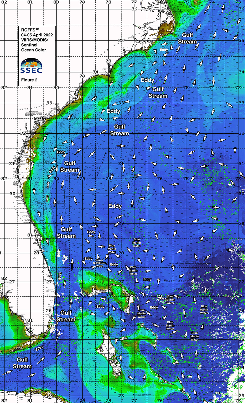
Figure 2a: This year’s Florida Keys to Cape Hatteras, NC conditions derived from the ocean color/chlorophyll imagery during April 04-05, 2022 from the VIIRS sensors on SNPP satellite and the Aqua and Terra sensors on the MODIS satellite provided by University of Delaware in combination with the ESA’s Sentinel 3 satellites. We consider this an image pair with the above SST Figure 1a image. Same main features and surface currents labeled.
[/et_pb_text][/et_pb_column][et_pb_column type=”1_2″ _builder_version=”4.6.3″ _module_preset=”default”][et_pb_text _builder_version=”4.6.3″ _module_preset=”default” hover_enabled=”0″ sticky_enabled=”0″ admin_label=”2021 CHL”]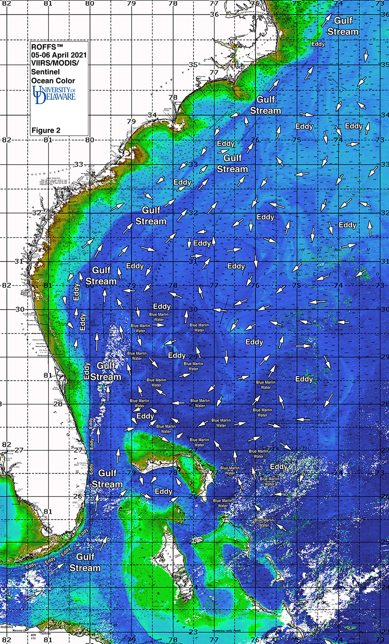
Figure 2b: Last year’s Florida Keys to Cape Hatteras, NC conditions derived from the ocean color/chlorophyll imagery during April 05-06, 2021 from the VIIRS sensors on SNPP satellite and the Aqua and Terra sensors on the MODIS satellite provided by University of Delaware in combination with the ESA’s Sentinel 3 satellites. We consider this an image pair with the above SST Figure 1a image. Same main features and surface currents labeled.
[/et_pb_text][/et_pb_column][/et_pb_row][et_pb_row _builder_version=”4.6.3″ _module_preset=”default”][et_pb_column type=”4_4″ _builder_version=”4.6.3″ _module_preset=”default”][et_pb_text _builder_version=”4.6.3″ _module_preset=”default” hover_enabled=”0″ sticky_enabled=”0″]We were able to use imagery from April 4th to April 6th for this analysis. It is also worth noting that we try to keep the color pallets consistent for direct comparisons from year-to-year. Furthermore, the directional flow of the water was derived from our ROFFS™ sequential image analysis, following the water from image to image based on the water masses distinct, i.e., signature value. An example of this year’s SST satellite infrared imagery in greytone can be found on the ROFFS™ YouTube™ site (Click Here). Viewing the movie will allow one to follow the flow of the water and numerous eddies within the Gulf Stream region from offshore of South Florida to North Carolina during the last two months, where the darker greytoned water represents the warmer water and white indicates clouds.
Conclusion
Based on what we have been observing over the last several weeks, the present overall early April ocean conditions (SST) for the Gulf Stream region between the Florida Keys to Cape Hatteras, NC appears slightly warmer than what we had observed in the prior year. This early increased SST could indicate an early or normal start for the southeast fishing season. However, the substantially lower presence of “Bahamas blue marlin water” closer to the Gulf Stream may indicate a later than normal arrival of the majority of the tuna, dolphin and marlin populations closer to the East Coast of the U.S. as we wait for this water to begin interacting with the eastern side of the Gulf Stream. Fortunately, we have begun receiving reports of tuna action north of the Bahamas in conjunction with earlier reports of marlin and dolphin fishing action in late March. Additionally, south Florida sailfish action has begun to heat up as well. Earlier reports of wahoo from north Florida to the Charleston area in late February and early March also suggests that the fish are out there. As a result, now is a good time to be either fishing already or your boat should be in the water waiting for those weather windows, especially South Carolina and North where the water and weather should improve over the next few weeks into May. We want you to take advantage of the good ocean conditions and the early fishing season. Once the water continues to warm after what appears to have been the last of the seasonal cool fronts pass through, the offshore fishing season will have begun over most of the areas from Georgia to Cape Hatteras. As such, this past weekend (April 09th-10th) was likely the last of the stronger seasonal cool fronts. It will not be long until the main migration of marlin, yellowfin tuna and mahi will be available off of North and South Carolina. In fact, reports of mahi action has already been positive in larger numbers in the Bahamas and Florida in places compared to last year at this time.
It is important to note that good fishing action on a daily basis is strongly linked to local, short-term (daily) current conditions that concentrate the fish once the preferred habitats of the fish are in a particular region. When the water mass boundaries associated with these currents are geographically stable and favorable, i.e., persistently pushing over “good” bottom topography and/or in a favorable inshore direction, then they concentrate the baitfish and larger fish can be found foraging. Relatively short-term (hourly/daily) and relatively small-scale (1-5 mile) movements of the currents and their associated water mass boundaries are often in control of the level of fishing productivity on any given day. Our experience indicates that to reliably forecast specific concentrations of fish on a daily basis one must evaluate the ocean conditions on these scales. Relatively small subtle changes in the currents and their associated water mass boundary zones often have dramatic effects on the distribution and concentration of fish.
The Gulf Stream conditions change rapidly so it becomes even more important to contact ROFFS™ (321.723.5759 / fishing@roffs.com / www.roffs.com) for the daily up-to-date detailed fishing forecasting analyses and get the inside track to where the better conditions will be tomorrow. We continue to monitor the coastal southeastern U.S. Ocean conditions especially the Gulf Stream and its related eddy features and how it relates to the local fishing environment as the larger recreational and tournament fishing season approaches. Get out and fish now and maximize your fishing experience by using ROFFS™ to locate the good spring conditions near you.
Safe and Successful Fishing
[/et_pb_text][/et_pb_column][/et_pb_row][/et_pb_section]