Originally Published: 4/4/2023 | coastwatch.noaa.gov | Please click here for original article.
The Caribbean overcame significant challenges in 2022 as Sargassum washed ashore in unprecedented amounts. More about that event can be found in a CoastWatch User Story here.
The challenge has since extended to the contiguous United States as the Great Atlantic Sargassum Belt drifts towards Florida. As more people encounter this nuanced macroalgae, it is ever-so important to track, study, and communicate effectively.
A Frequently Asked Questions (FAQs) for Sargassum was composed by the NOAA Atlantic Oceanographic & Meteorological Laboratory (AOML) in partnership with NOAA CoastWatch Caribbean, Gulf of Mexico and Atlantic OceanWatch Node. With permission, we reprint the FAQs here for expedience. Please visit the AOML-hosted Sargassum FAQ page for additional context on Sargassum research, tracking and monitoring. CoastWatch stakeholders may also be interested in the Experimental Weekly Sargassum Inundation Reports.
General Sargassum Information
What is Sargassum?
Sargassum is a type of floating brown algae, commonly called “seaweed.” These algae float at the sea surface, never attach to the sea floor, and they can aggregate to form large mats in the open ocean.
Where does it come from?
Historically, the majority of Sargassum aggregated in the Sargasso Sea in the western North Atlantic, with some small amounts found within the Gulf of Mexico and Caribbean Sea. In 2011, the geographic range expanded, and massive amounts of Sargassum moved west into the Caribbean Sea, Gulf of Mexico, and south tropical Atlantic, washing ashore in Florida, Puerto Rico, the US Virgin Islands, and most islands and coastal areas in the Caribbean Sea.
Why did the geographic range for Sargassum expand in 2011?
Researchers are still assessing various hypotheses about the cause of this first documented extreme event. One hypothesis proposes that during the winter of 2009–2010, the winds that typically blow to the east, from the Americas to Europe, strengthened and shifted to the south more dramatically and persistently than any other time in the 1900–2020 record. This shift in winds triggered a long-distance eastward dispersal of Sargassum, from the Sargasso Sea, toward the Iberian Peninsula in Europe and West Africa. After exiting the Sargasso Sea, the Sargassum drifted southward in the Canary Current and entered the tropics. Once in this new and favorable tropical Atlantic habitat, with ample sunlight, warm waters, and nutrient availability, the Sargassum flourished and has continued to grow.
In addition to changing wind patterns, other hypotheses include a combination of factors, such as the variation in the outflow of major rivers (e.g. Amazon and Orinoco), nutrient (nitrogen and phosphorus) concentration in the oceans, increase in the amount of phosphorus due to saharan dust, water temperature, and river runoffs.
Having established a new population, the Sargassum now aggregates almost every year, starting in January/February in a massive windrow or “belt” north of the Equator, along the region where the trade winds converge. During the late winter and early spring months, the Sargassum moves northward with the seasonal winds and currents. By June, this belt may stretch across the entire central tropical Atlantic. Large portions of this algae are then transported into the Caribbean Sea and Gulf of Mexico via the North Equatorial and Caribbean current systems.
Is the amount of Sargassum in the Atlantic/Caribbean increasing?
Since 2011, large accumulations of Sargassum have occurred every year in the Caribbean Sea, Gulf of Mexico, and tropical Atlantic, but the amount can vary from year to year.
The presence of Sargassum occurs over large areas from the tropical Atlantic in the east, to the Gulf of Mexico in the west, approximately 5,000 kilometers from the eastern tropical Atlantic to the west off the Mexican coast in the Caribbean Sea. Sargassum does not extend as a blanket (or blob) covering the full surface of the ocean in these regions. Instead, Sargassum floats in patches that range in size from a few centimeters to hundreds of meters. Some of these patches reach the coastal areas, including beaches, ports, and even intake systems for drinking water. The area that these patches cover has been significantly larger in recent years than prior to 2011.
What are the benefits of Sargassum to ocean ecosystems?
Sargassum, in normal amounts, provides habitat, food, protection, and breeding grounds for hundreds of diverse marine species, including commercially important species, such as tuna and swordfish, that feed on the smaller marine life present in Sargassum mats. If Sargassum reaches the coast in small/normal quantities, it may help to avoid beach erosion.
What are some of the drawbacks to having Sargassum wash ashore?
Out at sea, Sargassum is an important habitat for fish, sea turtles, and other marine organisms, but as it accumulates close to the coastlines it can smother valuable corals, seagrass beds, and beaches. As it washes ashore the seaweed begins to decay, attracting flies and other insects. Additionally, during its breakdown, Sargassum produces hydrogen sulfide gas, which smells of rotten eggs, repelling beachgoers and affecting the tourism industry that depends on pristine ocean conditions. Sargassum can also impact navigation, block water intake in desalination plants, and impact benthic ecosystems after/if they sink to the bottom of the ocean.
What threats, if any, does Sargassum present to human health?
Studies of the impact of Sargassum on human health started very recently and this is a topic that needs more time to be fully understood. However, when decomposed, Sargassum releases hydrogen sulfide (a gas) that may cause respiratory health problems. Sargassum is also known to often contain heavy metals that can be toxic to humans and animals.
NOAA Efforts
What research does NOAA CoastWatch or other parts of NOAA currently conduct on Sargassum?
Researchers at NOAA CoastWatch and AOML alongside the University of South Florida developed the experimental Sargassum Inundation Report (SIR) to provide an overview of the extent of Sargassum in the ocean and the risk of Sargassum washing into coastal waters, beaches, and shorelines in the Caribbean, Gulf of Mexico, and southeast Florida regions.
Research conducted at NOAA in partnership with the University of Miami, the University of South Florida, and LGL Ecological Research (TX) is also aiding to identify how Sargassum extends across the Caribbean, Gulf of Mexico, and tropical Atlantic, by assessing the role of ocean currents, winds, and waves in their motion. This work includes field experiments conducted to monitor the actual path of Sargassum using satellite tracking devices and surface drifters and satellite imagery, and physical representation of Sargassum in theoretical and numerical simulations. Please refer to the end of this document for a list of scientific manuscripts derived from this research.
Additionally, a collaboration between NOAA researchers and the Fearless Fund studies how seaweed, including Sargassum, naturally removes carbon dioxide from ocean waters and sequesters it in the seaweed. This project seeks to provide a management solution to wide-scale inundation of beaches, while also repurposing the Sargassum.
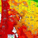
What is the experimental Sargassum Inundation Report?
The experimental Sargassum Inundation Report (SIR) provides an overview of the area of current Sargassum patches and the risk of Sargassum inundation in coastal regions of the Caribbean, tropical Atlantic, and Gulf of Mexico. SIR is an experimental product that updates on a weekly basis and uses satellite-based data to estimate the potential for Sargassum to wash ashore. It is not a forecast.
SIR shows the current conditions of Sargassum density and identifies coastal areas where Sargassum is within 50 km (30 miles) and, therefore, may potentially be impacted by Sargassum in the following days/weeks. The actual occurrence of coastal inundation will largely depend on local current, tide, wind, and wave conditions. The inundation potential is then categorized into three levels: low, medium, and high, which are largely based on the distance between patches of Sargassum to the coast, and the density and extent of these patches. Coastlines are color coded according to these three levels.
SIR serves as a source of information about the present distribution of Sargassum in different areas, potential to reach the coast, and can be used to monitor past movements of Sargassum in the region, which may allow researchers to hypothesize the evolution of the risk in time.
Can you predict where Sargassum is going and when it will arrive?
Researchers are using satellite images to identify areas in the open ocean where Sargassum density is large and estimate where beaching events may occur based on the density and proximity of Sargassum patches from the coast. While this is not a forecast, it does help communities prepare for possible inundation events. Researchers are using their knowledge of ocean currents, winds, and wave conditions to improve these estimates.
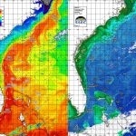
Identifying Sargassum from space is complex. Sargassum can be indirectly observed by satellite from space by measuring how light reflects from the ocean surface. NOAA CoastWatch and AOML are conducting research to assess the impact of ocean currents, winds, and waves on the distribution and path of Sargassum, to increase the accuracy of Sargassum pathway models. The Atlantic OceanWatch/Caribbean/Gulf of Mexico Node of CoastWatch (hosted at AOML) produces a monitor with the OceanViewer tool.
What are the satellites that are used to create the Sargassum Inundation Report?
Currently SIRs are created from a satellite-derived quantity (density of Sargassum), which is estimated by the University of South Florida using the NASA MODIS (Moderate Resolution Imaging Spectroradiometer) sensor onboard the NASA Aqua and Terra satellites.
Because MODIS is nearing the end of its mission, NOAA CoastWatch and AOML are working towards the upgrade of this product to integrate data from additional sensors to provide better coverage, especially in coastal areas, such as VIIRS on board SNPP, NOAA-20 and NOAA-21 polar orbiting satellite missions, OLCI (Ocean and Land Colour Instrument ) onboard Sentinel-3A and Sentinel-3B satellites, and MSI (Multispectral Instrument) onboard the ESA (European Space Agency) Sentinel-2A and Sentinel-2B optical satellites.
Have these satellite estimates of Sargassum and coastal inundation been validated with actual observations?
The estimates provided by the SIR have been validated in different areas of the Caribbean Sea and tropical Atlantic Ocean and a publication of this work has been submitted to Elsevier’s Aquatic Botany Journal.
Is there a citizen science effort to monitor Sargassum?
An international citizen science effort to collect mostly coastal observations of Sargassum is led by Florida International University, through the Epicollect Sargassum Watch web pages. Epicollect is a mobile and web application to collect science data. CoastWatch and AOML contribute to this effort through its Sargassum citizen science web page located here.
When might we see significant Sargassum inundation in Florida from the Great Atlantic Sargassum Belt? (Spring 2023)
The motion, extent, and density of Sargassum is very complex – it grows, sinks, and moves according to ocean currents, winds, and waves. Therefore, sometimes it may not be possible to describe trajectories in advance, but rather a general description of how the average extension and density have changed. Projecting an accurate path of Sargassum is challenging and a current area of intense research. At this moment, the timing of Sargassum beaching cannot be predicted.
There are two main sources of Sargassum reaching the Gulf of Mexico, one is local and peaks in April-May, and the second one is the Caribbean Sea which peaks during the summer months.
Large amounts of Sargassum are currently located in the Caribbean Sea, moving towards the Yucatan Peninsula, and spreading through the Gulf of Mexico by the Loop Current. There are two main sources of Sargassum located in the Gulf of Mexico, one is local and peaks in April-May, and the second one is the Caribbean Sea which peaks during the summer months.
The Loop Current flows through the Florida Straits and off the east Florida coast, where it is known as the Florida Current, and into the Gulf Stream as it heads north up the eastern coast of the US. The very strong Loop Current is now transporting moderate amounts of Sargassum that were previously located in the Caribbean Sea, with larger amounts potentially on the way. Some of the Sargassum in the Gulf of Mexico also originates locally. Whether the Sargassum will beach on the coast of Florida, including the Florida Keys, will largely depend on the local wind, wave, and tide conditions. Given the complexity of its motion, growth, and decay, it is not possible to forecast the timing of beaching. However, given the size and number of the current Sargassum patches, there is a strong chance that Sargassum carried by the Florida Current may reach the Florida coast despite wind and wave conditions. As of mid March 2023, satellite observations indicate that some of this Sargassum has already reached the northern coast of Cuba.
How does the size of the 2023 bloom compare to others since Sargassum began to be observed in the tropical Atlantic and Caribbean in 2011?
Sargassum outlooks are published once a month by the University of South Florida. These outlooks show maps with the monthly (past month) extensions of Sargassum. The current (February-March, 2023) total extension of Sargassum in the tropics is similar to the largest events that occurred in previous years (especially 2018), with large extensions of Sargassum observed in the Caribbean Sea being observed since February. While this Sargassum remains at the sea surface and moves with help from ocean currents, winds, and waves, it may grow and increase its density, provided that it encounters warm temperatures and plenty of nutrients. If the large amount of Sargassum that is presently in the Caribbean Sea remains at the surface, it has the potential to spread more widely throughout the Gulf of Mexico and then by the Loop Current and Florida Current (the name of the Gulf Stream off Florida) to reach the Florida Keys and the east Florida coast and Bahamas.