Please click here to view full 2023 ROFFS™ South Season Fishing Forecast as a PDF.
Southern Florida to Cape Hatteras Spring Season Preview 2023: UPDATE ON U.S. EAST COAST GULF STREAM CONDITIONS
By ROFFS™ | James L. W. King
ROFFS™ continues its spring preview series by providing an overall update of the oceanographic conditions during early April for the east coast of the United States from the Florida Keys north to Cape Hatteras, NC including the entire offshore Gulf Stream region. As always, we have used a combination of many different data sets, but mainly sea surface temperature (SST) and ocean color/chlorophyll images. We will discuss these overall ocean conditions for the present spring season and how these conditions may translate to the near future fishing season.
For forecasting short-term oceanographic conditions related to finding fish, ROFFS™ uses real-time direct observations rather than unproven ocean models and longer-term composites. We have learned that evaluating the pre-season conditions, along with regional climate models, provides insight into future seasonal trends for fishing. Experience and understanding of the ocean – atmospheric dynamics is our guide as we have had moderate success in forecasting seasonal trends of fishing productivity based on the stepwise progression in the location of the fishes’ preferred habitat, based on temperature and water color. Please reference our 2023 Bahamas forecast for more in-depth discussion on the environmental and climate indicators that goes into our detailed evaluation of the southeastern United States fishing forecasting analysis (Click Here).
Background and Some Observations for 2023
It is important to look at the year-to-year trends including the anomalies to gain insight into the location and condition of the fishes’ preferred habitat compared with previous years. Comparing similar locations and features to last year during the same early April time period we found that the overall SST throughout the southeast was warmer than 2022. A larger amount of warmer (78°F-80°F) water has been observed to the north of the Bahamas compared to 2022 where we had observed a mix of cooler (75°F-79°F) water closer to the ledges off Walker’s Cay. North of Walker’s Cay and the Abaco Islands there are several eddies and dynamic oceanographic features with a lot of unstable conditions. However, the fishing should be improving over the next couple of weeks as larger amounts of darker “blue marlin water” continues to push north of Abaco and Walker’s Cay to the northwest, joining the Gulf Stream.
Despite the overall higher temperatures, we observed slightly cooler (0.7-0.9°F cooler) water in the Florida Keys (80.6-81.5°F) in 2023 compared to 2022 (81.5-82.2°F). Moving northwards, we begin to see slightly warmer temperatures in the main body of the Gulf Stream. The Gulf Stream was nearly half a degree warmer (80.5°F) in 2023 along the east coast of Florida compared to 2022 (80.1°F). However, inshore conditions show much higher temperatures towards the coastline at Cape Canaveral (75°F-77°F) compared to 2022 (71°F-74°F). This trend continues north from Jacksonville toward the offshore areas near Cape Fear. The main body of the Gulf Stream was slightly warmer (0.5°F: 79.8°F-80.6°F) in 2023 compared to 2022 (79.4°F-80.1°F) while inshore conditions are much warmer (2023: 66-70°F vs 2022: 64-68°F). Similar conditions were observed from Cape Fear to Cape Hatteras between 2022 and 2023 with slightly cooler water moving to the far northeast corner of this chart area (2023: 78.9°F vs 2022: 79.4°F). However, similar inshore trends continue where we have observed several Gulf Stream eddy filaments being pushed inshore near Cape Lookout during the late winter and early spring period. These coastal waters (~10-12 miles east) between Cape Fear and Cape Hatteras have experienced warmer water earlier in the 2023 season (64/65°F-69°F) compared to 2022 (61°F-66°F). Keep in mind, the inshore SST from central and north Florida to Georgia and South Carolina have only recently begun to heat up while slightly increased temperatures have been pushing inshore off of Cape Lookout and Cape Hatteras for several weeks.
Nowcast Analysis
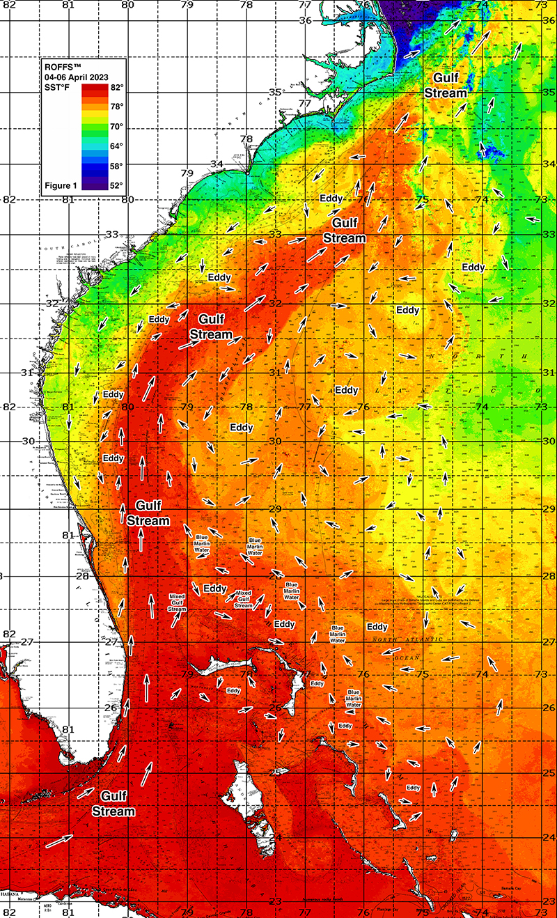
The Gulf Stream Current, including its related eddies and filaments along the current’s eastern and western side are the preferred habitat of the highly migratory species for this time of year and are the most important conditions that we are studying. It is the day-to-day and hour-to-hour movements of these Gulf Stream related features that are important to monitor when deciding where to fish on a daily basis. Although we are only showing a two-to-three-day snap shot of the conditions in this report from early April (Figure 1a/b and 2a/b), we can briefly discuss the trends we see based on these early spring oceanographic conditions and related fishing reports that may provide insight into the near-future fishing season.
Figures 1a/b were derived from a variety of U.S. and European satellites during the early April (April 04-06, 2023 and April 05-06, 2022) period and Figures 2a/b were derived from U.S. SNPP VIIRS, Aqua/Terra MODIS Ocean color/chlorophyll, and European Space Agency’s (ESA) Sentinel 3 imagery during this same period (April 04-06, 2023 and April 05-06, 2022). As the exact values of the original data from different satellite sensors (VIIRS and MODIS) are not the same, we cross-calibrated the data to derive images that have realistic and consistent watercolor. This is one of the many techniques that we derived during the valuable NASA Earth Science Program projects that ROFFS™ has been involved with. We cannot over-stress the importance of NASA’s Earth Science Program for helping to understand the ocean’s dynamic ecosystem and how it impacts food security, homeland security and land-ocean interactions.
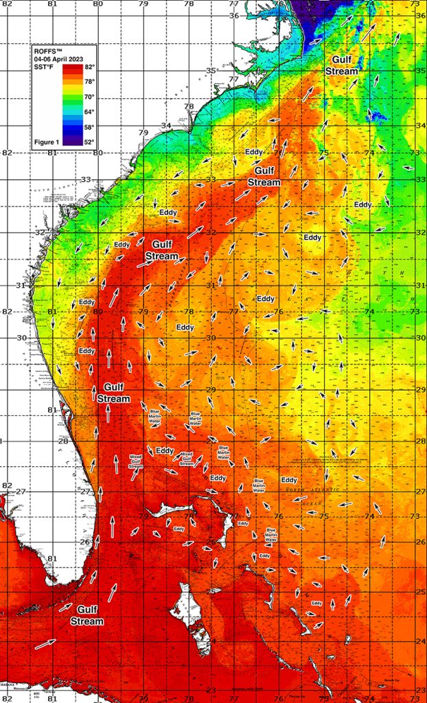
Figure 1a: This year’s Florida Keys to Cape Hatteras, NC conditions were derived from a variety of infrared sensors to get SST from NASA, NOAA, JPSS and ESA satellites during April 04-06, 2023. Main features and surface currents are labeled.
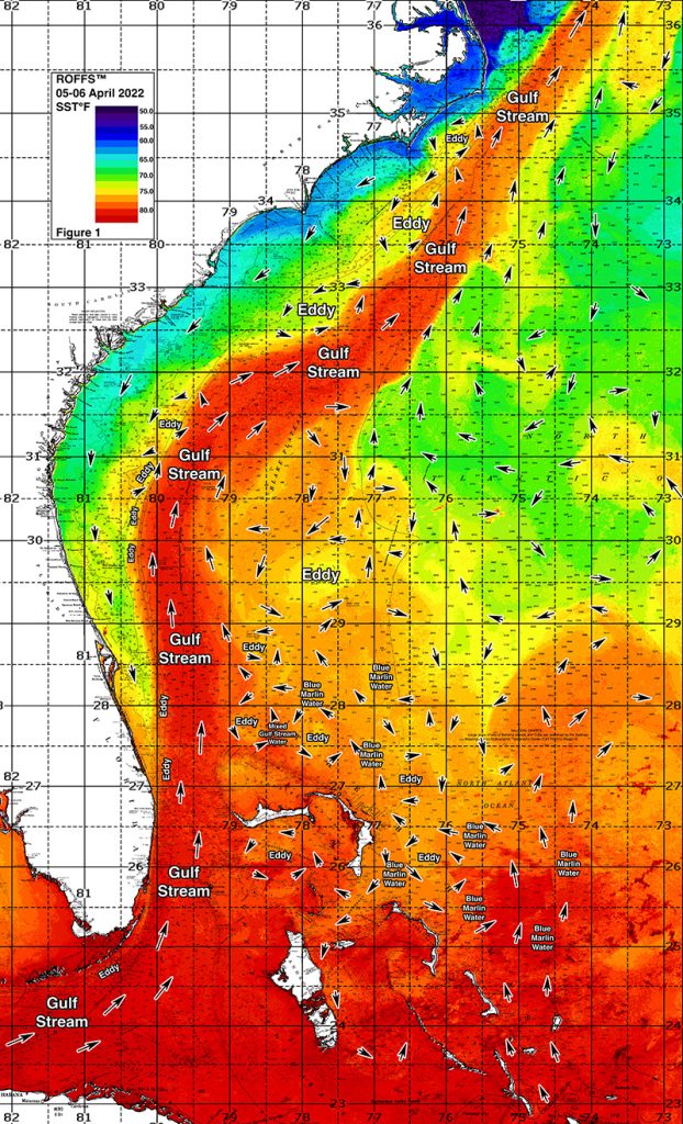
Figure 1b: Last year’s Florida Keys to Cape Hatteras, NC conditions were derived from a variety of infrared sensors to get SST from NASA, NOAA, JPSS and ESA satellites during April 05-06, 2022. Main features and surface currents are labeled.
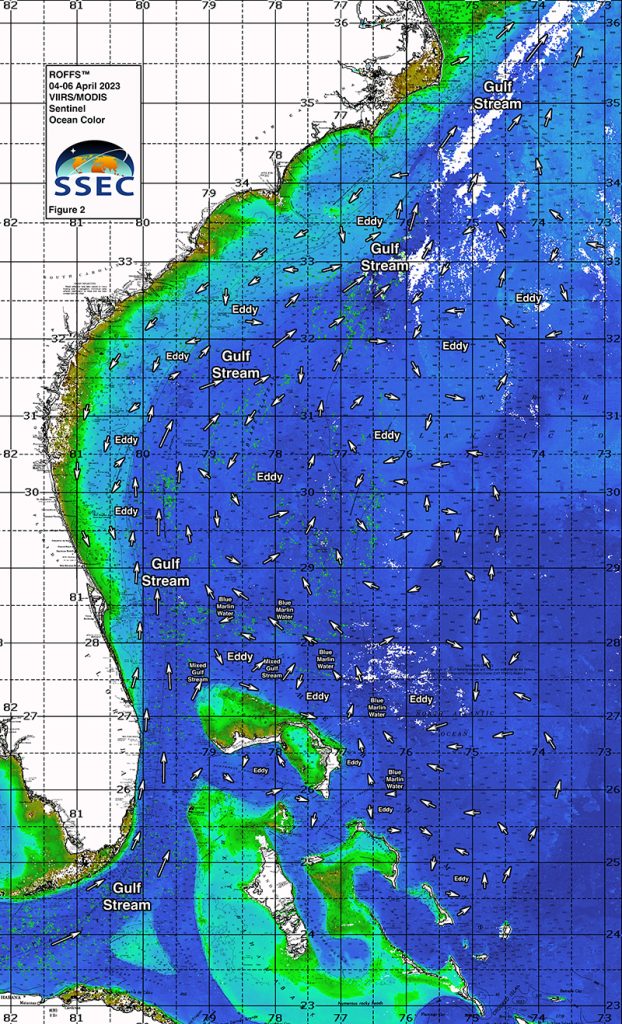
Figure 2a: This year’s Florida Keys to Cape Hatteras, NC conditions derived from the ocean color/chlorophyll imagery during April 04-06, 2023 from the VIIRS sensors on SNPP and NOAA 20 satellites and the Aqua and Terra sensors on the MODIS satellite provided by University of Wisconsin-Madison in combination with the ESA’s Sentinel 3 satellite. We consider this an image pair with the above SST Figure 1a image. Same main features and surface currents labeled.
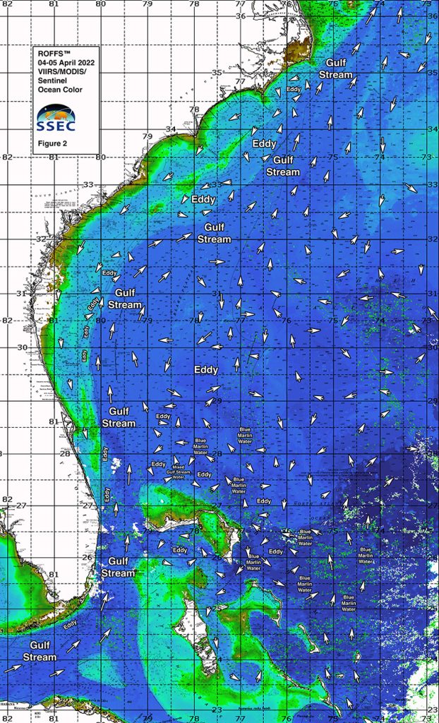
Figure 2b: Last year’s Florida Keys to Cape Hatteras, NC conditions derived from the ocean color/chlorophyll imagery during April 04-05, 2022 from the VIIRS sensors on SNPP satellite in combination with the Aqua and Terra sensors on the MODIS satellite provided by University of Wisconsin-Madison in combination with the ESA’s Sentinel 3 satellite. We consider this an image pair with the above SST Figure 1a image. Same main features and surface currents labeled.
We were able to use imagery from April 4th through 6th for this year’s analysis. The directional flow of the water was derived from our ROFFS™ sequential image analysis, following the water from image to image based on the water masses distinct, i.e. signature value. An example of this year’s SST satellite infrared imagery in greytone can be found on the ROFFS™ YouTube™ site (Click Here). Viewing the movie will allow one to follow the flow of the water and numerous eddies within the Gulf Stream region from offshore of eastern and southern Florida to North Carolina during the last two months, where the darker greytoned water represents the warmer water and white indicates clouds.
Conclusion
Based on what we have been observing over the last several weeks, the present overall early April ocean conditions (SST) for the Gulf Stream region between the Florida Keys to Cape Hatteras, NC has recently begun to heat up resulting in higher SST throughout the southeast compared to last year. This increase in SST likely indicates a normal or early start to the southeast fishing season for the western Gulf Stream areas from Cape Canaveral and north. This may also be aided by the increase in abundance of warmer “Bahamas blue marlin water” moving northwest from Abaco and Walker’s Cay to the eastern side of the Gulf Stream these past two weeks. As this water continues interacting with the eastern side of the Gulf Stream, conditions will continue to improve along the East Coast. Fortunately, we have already begun receiving reports of tuna, dolphin, and marlin action north of the Bahamas, validating these oceanographic observations. Additionally, off of south Florida to the Keys, sailfish action has been decent in spurts, when conditions are right. Favorable reports of larger wahoo from north Florida to the Carolinas suggest that the fish are starting to arrive in larger numbers as well. As a result, now is a good time to be either fishing already or have your boat in the water waiting for favorable weather windows, especially north of Florida. Once the water continues to warm after what appears to have been one of the last of the seasonal cool fronts pass through, the better offshore fishing season will have begun over most of the areas from Georgia to Cape Hatteras. It will likely not be long until the main migration of marlin, yellowfin tuna, and mahi will be available off of North and South Carolina so stay tuned to ROFFS™ for future updates.
It is important to note that good fishing action on a daily basis is strongly linked to local, short-term (daily) current conditions that concentrate the fish once the preferred habitats of the fish are in a particular region. When the water mass boundaries associated with these currents are geographically stable and favorable, i.e., persistently pushing over “good” bottom topography and/or in a favorable inshore direction, then they concentrate the baitfish and larger fish can be found foraging. Relatively short-term (hourly/daily) and relatively small-scale (1-5 mile) movements of the currents and their associated water mass boundaries are often in control of the level of fishing productivity on any given day. Our experience indicates that to reliably forecast specific concentrations of fish on a daily basis one must evaluate the ocean conditions on these scales. Relatively small subtle changes in the currents and their associated water mass boundary zones often have dramatic effects on the distribution and concentration of fish.
The Gulf Stream and related features change rapidly so it becomes even more important to contact ROFFS™ (321.723.5759 / fishing@roffs.com / www.roffs.com) for daily up-to-date detailed fishing forecasting analyses and get the inside track to where the better conditions will be tomorrow. We continue to monitor the coastal southeastern U.S. Ocean conditions especially the Gulf Stream and its related eddy features and how it relates to the local fishing environment as the larger recreational and tournament fishing season approaches. Get out and fish now and maximize your fishing experience by using ROFFS™ to locate the good spring conditions near you.
Safe and Successful Fishing