Please click here to view full 2023 ROFFS™ GOM Season Fishing Forecast as a PDF.
By Gregory J. Gawlikowski
Introduction
Continuing our series of “Early Season Previews”, ROFFS™ is providing a spring analysis of the oceanographic conditions for the Gulf of Mexico region derived using a combination of high-resolution satellite data including infrared sea surface temperature (SST) and ocean color/chlorophyll images from late April-Early May 2023. In this preview, we will discuss the overall ocean conditions for the current spring fishing season and how they may transition into the summer conditions compared to the similar time period last year.
ROFFS™ (www.roffs.com) has a 35+ year history of monitoring the ocean conditions throughout the Gulf of Mexico for research and fishing applications. Infrared (IR) satellite data is used to observe the SST and ocean color data is used to derive indices of phytoplankton (chlorophyll), water clarity, water color and colorized dissolved organic material (CDOM). Combined with other oceanographic data and using sequential image analysis, these data allow one to visualize the dynamic ocean currents. The satellite data are derived from a variety of sources including NASA, NOAA, University of Wisconsin and the European Space Agency (ESA). ROFFS™ also incorporates a variety of different data derived from NOAA buoys, drifting buoys, and satellite altimeters into its comprehensive fishing forecasting analyses. The altimeter data provides a relatively coarse spatial (~10 mile) and temporal resolution (5-8 days) that limits the data’s usage to studying large-scale circulation. It is generally not useful for evaluating smaller scale, near shore and short-term (daily and sub-daily) changes in the ocean currents or their water mass boundaries that often control the location of forage (bait) fish and the larger, more valuable predator/pelagic fish.
Background and Some Observations for 2023
It is important to look at the year-to-year trends and anomalies along with fishing reports to get a better understanding of how the ocean conditions compare regarding the conditions and location of the fishes preferred habitat and the likelihood of a productive fishing year (Figure 1 and 2). Comparing the similar locations and features to last year, the SST of the core of the Loop Current for late April 2023 is approximately 81.3°F-82.7°F which is about the same as the past two years over this same time period. Please note that this year, although there are some intrusions of relatively warmer (76°F-77°F) water with Loop Current origins moving into the De Soto Canyon area due to the interaction with several eddies, the northern boundary of the Loop Current appears to be at a lower latitude than last year with the northern edge of the main body of Loop Current water occurring further southward, southwest of the Lloyd Ridge towards the Atwater Valley area. While we had observed a large Loop Current eddy feature break off from the main Loop Current circulation earlier this year, this feature has progressed southwestward over the Mississippi Canyon and Green Canyon areas and has moved further southwestward where it is currently centered southeast of Texas.
The main body of the Loop Current appears to show normal warm temperatures again this year; and the inshore waters do appear to have similar temperatures to last year. The SST in the northwestern Gulf of Mexico is currently 75.0°F-76.5°F inshore with some fingers of warmer 77.0°F-78.0°F water occurring offshore towards the 100+ fathom depths which is similar to what we observed in these areas last year. The SST in the offshore southwestern Gulf of Mexico area was observed to be within the 79.0°F-81.0°F range this year, which is slightly cooler compared to the same time period last year (80.0°F-83.0°F), but still much warmer than the 76.0°F-77.0°F that was observed back in 2018/2019. Note that the coastal SST’s along the west coast of Florida (75.0°F-77.0°F) are showing temperatures that are slightly cooler compared to the past several years (77.0°F-79.0°F), but they still range 2.0°F – 3.0°F higher than they were during the same time period back in 2016-2017. Normally, a strong contributor to the warmer SST’s is the presence of an El Niño period as observed in 2020. We have been in a La Niña phase for the better part of the past three years. This long run of La Niña conditions is abnormal. However, we have finally transitioned out of the La Niña stage and are currently in an ENSO neutral stage. It is forecasted to be in an ENSO neutral stage through the summer and then move toward an El Niño phase toward the end of the year (https://www.cpc.ncep.noaa.gov/products/analysis_monitoring/lanina/enso_evolution-status-fcsts-web.pdf).
Currently this year there are no large, recently detached, Loop Current eddy features present in the eastern Gulf of Mexico. The Loop Current eddy that had been in the Mississippi Canyon/Green Canyon area a few months ago has now moved into the western Gulf of Mexico southeast of Texas (centered towards 93°30’W & 25°30’N). At the end of April 2023 we were able to observe several eddy features, both clockwise and counter-clockwise rotating, located south/southeast of the Mississippi River Delta region/northwest of the main Loop Current circulation that continue to pull clean blue water with Loop Current origins northward over the Lloyd Ridge region and towards the area east of the Double Nipple/south of the De Soto Canyon area with some of this water being pulled westward towards the Mississippi Canyon region. Although the temperatures are slightly cooler than last year due to the southward orientation of the northern edge of the main Loop Current circulation, some of the cleaner blended blue to blue water is also moving over the Steps region southwest of the Spur. This circulation, along with relatively warm SST’s, support normal arrival time (early-to-mid May) in the northeastern Gulf of Mexico of the pelagic species that you usually target offshore (e.g. yellowfin tuna, wahoo, dolphin, kingfish, sailfish, marlin, swordfish, cobia, etc.) as indicated in the fishing reports below.
Recent reports indicate that kingfish action again this year has been decent in March and April offshore of western Florida with sailfish, dolphin (mahi-mahi), blackfin/yellowfin tuna and marlin also being caught offshore of southwest FL. There have also been reports of early season marlin, along with dolphin, wahoo and larger yellowfin tuna action south/southwest of LA into the Mississippi Canyon and Green Canyon areas and near the offshore rigs, which is not surprising based on the circulation and SST’s we have been observing in the areas east of the Green Canyon towards the Mississippi Canyon, south/southeast of the Mississippi River Delta and eastward towards the Steps, Spur and south of the De Soto Canyon. In the western Gulf of Mexico there have also been reports of releases of blue marlin along with larger bluefin tuna offshore towards the Perdido and Diana rigs, along with reports of good bites with mahi, wahoo and yellowfin tuna near semi-submersible rigs and inshore areas towards the Aransas Bank and Baker’s Rocks.
Nowcast Analysis
For forecasting short-term oceanographic conditions related to finding fish, ROFFS™ first uses real-time direct observations based on high-resolution satellite data rather than unproven and unreliable ocean models or longer-term composites. We have learned that evaluating the preseason conditions along with regional climate models provides insight into future seasonal trends for fishing. Experience and understanding the ocean – atmospheric dynamics is our guide as we have had moderate success in forecasting seasonal trends of fishing productivity based on the stepwise progression in the location of the fishes’ preferred habitat based on movement of water masses, stability, temperature (SST) and water color.
The circulation of the Gulf of Mexico is controlled by the location and flow of the Loop Current, large mesoscale eddies, local and regional winds, and the dynamic thermohaline forces of the fresh water runoff mixing with the ocean water. The Loop Current is a warmer ocean current that flows northward between Cuba and the Yucatan Peninsula into the Gulf of Mexico. It makes a “loop” east/northeastward within the eastern Gulf then southward before exiting through the Straits of Florida and re-joining the Gulf Stream. It is the dominant circulation feature in the eastern Gulf of Mexico and its location varies on a weekly, monthly and annual time scale. The Loop Current and related eddies can be a highway and spawning grounds for pelagic fish moving into the Gulf of Mexico from the Caribbean Sea. The eddies that the Loop Current sheds can be an important fish habitat for longer periods of time as they progress from the eastern Gulf of Mexico to the northeastern, central and western Gulf of Mexico over a time period of several months.
Figure 1a was derived from a variety of U.S. (NASA, NOAA, JPSS and ESA) satellites during the late April to early May (April 30-May 1, 2023) period and Figure 2a was derived from the U.S. SNPP and JPSS VIIRS, Sentinel 3A and 3B, Aqua MODIS and Terra MODIS ocean color/chlorophyll imagery during this same period (April 30-May 1, 2023). As the exact values of the original data from different satellite sensors (VIIRS, MODIS and Sentinel) are not the same, we cross-calibrated the data to derive images that had realistic and consistent watercolor. This is one of the many techniques that we derived during the valuable NASA Earth Science Program projects that ROFFS™ has been involved with over the years.
Figure 1b was derived from a variety of U.S. (NASA, NOAA, JPSS and ESA) satellites during the late April (April 24-26, 2022) period and Figure 2b was derived from the U.S. SNPP and JPSS VIIRS, Sentinel 3A and 3B, Aqua MODIS and Terra MODIS ocean color/chlorophyll imagery during this same period (April 24-28, 2022).
We could not use single and same day imagery for the SST and ocean color data due to cloud cover interference, so we used a combination of imagery and the time-tested ROFFS™ cloud reduction techniques to produce these relatively cloud-free images. However, for comparison purposes we consider these images as an equal image pair for the purposes of this discussion. The directional flow, not speed of the water was derived from our ROFFS™ sequential image analysis, following the motion of the water from image to image based on the water masses distinct, i.e. signature value. An example of this years SST satellite infrared imagery in greytone can be found on the ROFFS™ YouTube™ site (https://www.youtube.com/watch?v=9CzCCwmyjIU). Viewing the movie will allow one to observe the flow of the water within the Gulf of Mexico region during the last two months (March 1-May 1, 2023), where the darker greytoned water represents the warmer water and white indicates clouds.
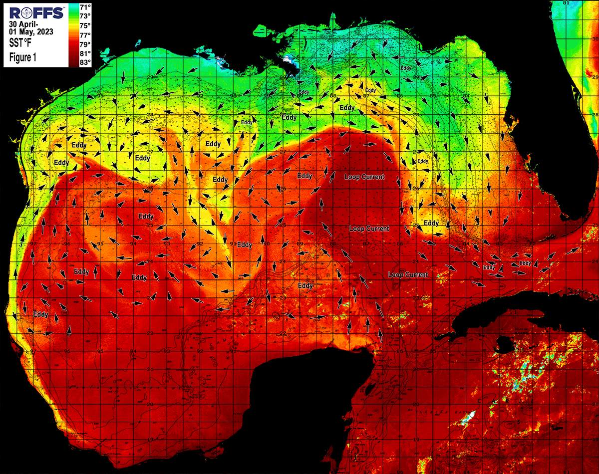
Figure 1a: This year’s Gulf of Mexico conditions were derived from a variety of infrared sensors to get SST from NASA, NOAA, ESA and JPSS satellites during April 30-May 1, 2023. Main features and surface currents are labeled.
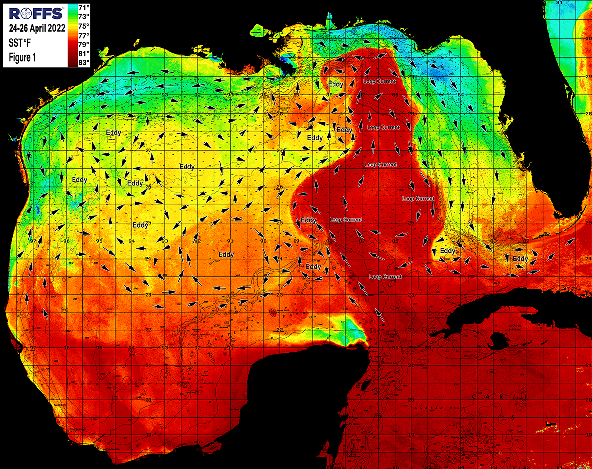
Figure 1b: Last year’s Gulf of Mexico conditions were derived from a variety of infrared sensors to get SST from NASA, NOAA, ESA and JPSS satellites during April 24-26, 2022. Main features and surface currents are labeled.
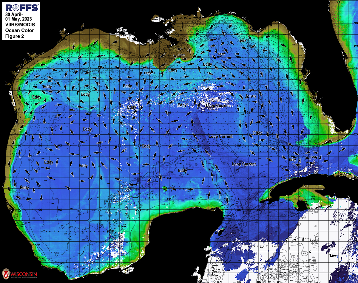
Figure 2a: This year’s Gulf of Mexico conditions derived from the ocean color/chlorophyll imagery during April 30-May 1, 2023 from the VIIRS sensors on SNPP and JPSS satellites in combination with the Aqua and Terra sensors on the MODIS satellite provided by the University of Wisconsin and from ESA’s Sentinel 3A & 3B. We consider this an image pair with the above SST Figure1a image. Same main features and surface currents labeled.
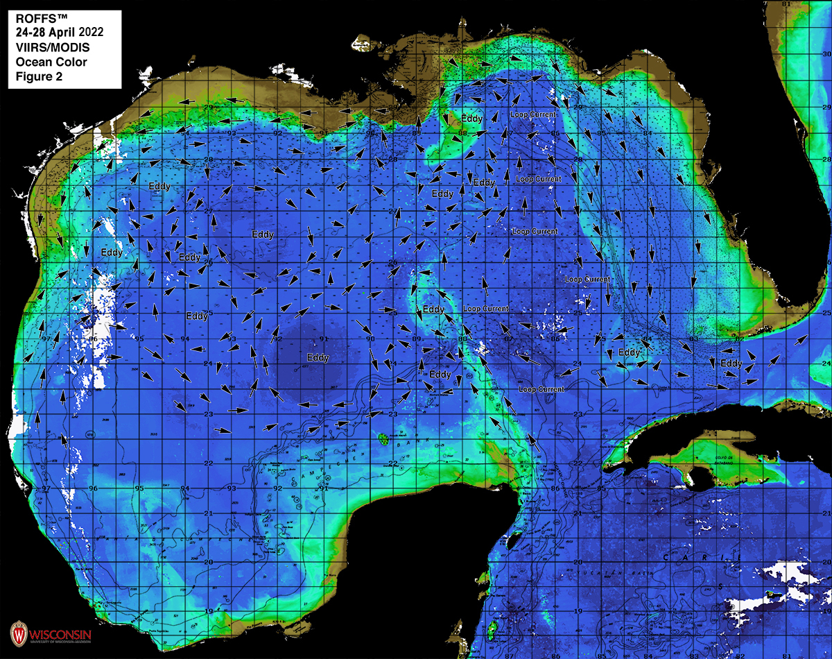
Figure 2b: Last year’s Gulf of Mexico conditions derived from the ocean color/chlorophyll imagery during April 24-28, 2022 from the VIIRS sensors on SNPP and JPSS satellites in combination with the Aqua and Terra sensors on the MODIS satellite provided by the University of Wisconsin and from ESA’s Sentinel 3A & 3B. We consider this an image pair with the above SST Figure1b image. Same main features and surface currents labeled.
When evaluating this year’s late April to early May oceanographic conditions, we continue to observe northern location of the main body of the Loop Current located in a more typical position and not as far northward compared to last year. However, as previously stated, this year we did observe several clockwise and counter-clockwise rotating eddy features north/northwest of the main Loop Current circulation which have helped the cleaner blue water with Loop Current origins move further north/northwestward towards the Spur west/southwest of the De Soto Canyon and southwestward towards the areas south/southwest of the Mississippi River Delta region. These conditions likely account for the recent early season catches of yellowfin tuna, dolphin, wahoo, swordfish and perhaps blue marlin in the northeastern Gulf of Mexico. Furthermore, although the main eastern edge of the Loop Current is 100+ miles west/southwest of Tampa, FL there is an abundance of cleaner bluer water over the areas inshore of the eastern Loop Current edge within 30 miles of the western FL coastline again this year for good chances at fishing action. In the eastern Gulf of Mexico it is important to keep an eye on the Loop Current and how it changes in the next month. Some things worth watching are if it keeps pushing further northward into the De Soto Canyon and how it interacts with the clockwise and counter-clockwise rotating eddies located north/northwestward of the main Loop Current flow along with the large counter-clockwise rotating eddy currently located west of the main body of the Loop Current (south of the Mississippi Canyon/southeast of the Green Canyon). These changes will determine the better fishing locations offshore of Florida, Louisiana, Alabama and Mississippi over the summer season.
Offshore of Texas and in the western Gulf of Mexico, two key eddy features, one counter-clockwise rotating (centered near 96°10’W & 26°45’N) and one clockwise rotating (centered near 95°30’W & 27°15’N), continue to circulate warmer blue water over the rigs and good bottom areas offshore of the TX coastline resulting in the recent catches of yellowfin tuna, wahoo, mahi, blue marlin and even large bluefin tuna offshore in these areas. Of note is the large, clockwise rotating eddy centered near 93°30’W & 25°00N. This is an older Loop Current Eddy with a bluer and warmer signal that broke off from the main Loop Current circulation earlier this year and continues to progress west/southwestward. It is important to keep track of this eddy, as it will likely continue to move slowly westward then southwest and with it better marlin conditions. Stay tuned and call ROFFS™ to get updated conditions within this entire Gulf of Mexico region to find the best locations to fish nearest to your inlet.
Conclusion
Based on what we are observing currently and what we have been observing over the last several weeks, the present ocean conditions for the Gulf of Mexico region continue to look encouraging again this year. There are SSTs that are within the preferred fishing habitats of tuna, dolphin and billfish along with bluer water over much of the typical fishing zones within the Gulf of Mexico early this spring season. The overall takeaway is that the majority of the Gulf of Mexico SSTs are slightly warmer than in year’s past (especially in the west) and in line with what we had observed during last year’s favorable early fishing season. Furthermore, there appears to be an abundance of bluer cleaner water closer to the coast in many regions similar to what we had observed last year (especially in the east to northeast and also east/southeast of Texas). The warmer SST observed again this year may mean an earlier to normal arrival of the larger numbers of target fish species closer to shore. Furthermore, although there are no large Loop Current eddies present this year in the eastern Gulf of Mexico, there is still an abundance of other favorable blue water features (smaller eddies) that will continue to keep the warmer water within these preferred fishing zones allowing the already favorable fishing conditions to continue through the spring and into the summer season. Of particular interest, although the northern edges of the Loop Current circulation are further southward than last year, there are large amounts of bluer water with Loop Current origins water far north for good early season fishing conditions directly offshore of Alabama, Mississippi, and Northwest Florida right now and this should continue for the next few weeks and may even improve further IF the northern edge of the main Loop Current circulation pushes further northward towards the De Soto Canyon area. Overall, we think that the Gulf of Mexico conditions for spring to early summer are above average again this year and are shaping up very well for rest of the spring season into the bigger summer fishing season. We believe now is time to start fishing and call ROFFS™ for the latest and greatest updates to the ever-changing ocean conditions. Please continue to get your fishing reports and photos in to us at feedback@roffs.com and be sure to follow us @roffsfishing on Instagram and Facebook.
It is important to note that good fishing action on a daily basis is strongly linked to local, short-term (days) current conditions that concentrate the fish once the preferred habitats of both the baitfish and larger predatory pelagic fish are in a particular region. When the water mass boundaries associated with these currents are geographically stable and favorable, i.e., persistently pushing over “good” bottom topography and/or in a favorable inshore direction, then they concentrate the baitfish and larger fish can be found foraging. This indicates that the fishing action on any given day is controlled by relatively short term (hourly to daily) and relatively small-scale (5-10 mile) movements of the currents and their associated water mass boundaries. Our experience indicates that to reliably forecast specific concentrations of fish on a daily basis one must evaluate the ocean conditions on these scales. Relatively small subtle changes in the currents and their associated water mass boundary zones often have dramatic effects on the distribution and concentration of fish, therefore it is extremely important to monitor these conditions and the changes in them on a daily basis.
Contact ROFFS™ (321-723-5759 / fishing@roffs.com / www.roffs.com) for daily real-time detailed fishing forecasting analyses and get the inside track to where the better conditions will be tomorrow or while you are out fishing. We continue to monitor the Gulf of Mexico conditions and how they change from day-to-day as the recreational fishing season has arrived and the bigger tournament fishing season is arriving soon. The bottom line is: GET PREPARED and GET OFFSHORE NOW and take advantage of the weather windows, for the favorable spring season fishing conditions have already started and should continue to improve through May and into the summer months.
Safe and Successful Fishing!
ROFFS™ Team