Please click here to view full 2023 ROFFS™ North Season Fishing Forecast as a PDF.
Northeast U.S. Spring Preview 2023: CONDITIONS LOOKING PROMISING THIS YEAR
By: Matthew A. Upton
ROFFS™ concludes its 2023 spring preview series by providing an overall update of the oceanographic conditions from mid-May offshore of the northeastern United States focusing on the Mid-Atlantic Bight region and its canyons that includes the zone from Cape Hatteras to Georges Bank into the Gulf of Maine. We utilize a combination of many different data sets, mainly satellite derived sea surface temperature (SST) and ocean color/chlorophyll images. In this analysis we will discuss the present ocean conditions and what it means for the upcoming late-spring to summer fishing season for the area north of Cape Hatteras, NC to Massachusetts offshore canyon regions.
As a reminder, for forecasting short-term oceanographic conditions related to finding fish, ROFFS™ uses real-time direct observations. We have learned that evaluating the preseason conditions along with regional climate models provides insight into future seasonal trends for fishing. Experience and understanding the ocean – atmospheric dynamics is our guide, as we have had moderate success in forecasting seasonal trends of fishing productivity based on the stepwise progression in the location of the fishes’ preferred habitat based on temperature and water color. Please reference our 2023 Bahamas forecast for more in-depth discussion on the environmental and climate indicators that goes into our detailed evaluation of the eastern United States fishing forecasting analysis (Click Here).
Background and Some Observations for 2023
It is important to look at the year-to-year trends including the anomalies to gain insight into the location and condition of the fishes’ preferred habitat compared with previous years. Comparing similar locations and features to last year during the same time period in mid-May we found that the SST of the core of the Gulf Stream off of Cape Hatteras, NC for 2022 was approximately 78.8°F to 79.4°F and for this year (2023) it is about 1.0°F warmer (79.4°F to 80.1°F), but about the same as it was in 2021. The SST of the coastal water off of New Jersey, Delaware and Maryland is approximately 3.0 to 4.0°F degrees warmer this year than during the same time period in 2022 and also warmer than in 2021. Similarly, the SST offshore of Long Island to Rhode Island is about 3.0°F to 4.0°F warmer than this time last year. However, the SST in the western Gulf of Maine is slightly cooler ~1.0°F than last year. These and other indicators, that will be described below, suggest a slightly earlier arrival and better forecast for the main push of tuna, wahoo, dolphin and billfish into the Gulf Stream section of the northeast U.S. region this year compared to the last two years and also an earlier arrival and likely a higher abundance of the main population of tuna, wahoo, dolphin and billfish to the northern canyon regions. Reports have confirmed that it has been an earlier arrival and better overall tuna, dolphin and even marlin season from Cape Hatteras to offshore of Virginia and in some of the northern canyons already (except tuna action has been slower than normal off of North Carolina in places). Even though the spring season has been relatively cool, these warmer than normal SST’s and earlier arrival of the larger amounts of pelagics corresponds with the much milder winter weather up in the northeast U.S and it is starting to warm up even more in the past couple of weeks. With June approaching, waters (especially inshore) will be starting to warm at an average rate of up to 0.5°F to 1.0°F per day triggering tuna, dolphin, wahoo and some billfish to start migrating north closer to the canyons in the upcoming weeks, especially with the number of promising eddies in this area that are or have been connected to the Gulf Stream along with a northern push of the Gulf Stream compared to last year.
One driver for trends and weather, and for the spring SST’s in the Northeast U.S. region can be attributed to the North Atlantic Oscillation (NAO) and its positive phase during the months of January and February, but then switching to a stronger negative phase in March and April. NAO index is based on the atmospheric surface sea level pressure difference between the Subtropical (Azores) High and the Subpolar Low within the North Atlantic Ocean (https://www.ncdc.noaa.gov/teleconnections/nao/). Typically, positive NAO phases mean higher winds, cooler SST’s and atmospheric temperatures (like this last winter early spring), but currently there is a switch to a negative phase in March and April which should mean a warming period and less winds in May and early June, which is encouraging for warming the SST and calmer winds that lead to relatively favorable fishing conditions and easier access offshore. Another possible factor to consider is the El Niño phase in the Pacific Ocean. Currently we are coming out of a La Niña phase and we are now in a ENSO-neutral stage (for the summer). It is forecasted by NOAA to transition to an El Niño phase this fall into the winter, which usually means normal to warmer SST’s in the Gulf of Mexico, Caribbean and east to northeast Pacific, but it remains to be seen what that means for waters offshore of the Northeastern U.S. and its fishing conditions.
Also, please see ROFFS™ recent Southeast U.S. Gulf Stream fishing conditions analysis (Click here). These Gulf Stream conditions to the south are usually a good indicator and associated with the main populations of mahi, yellowfin tuna and marlin along with other highly migratory species migrating north during the spring months. Reports from mid-April to mid-May have already indicated good (better than last year) wahoo, dolphin and even marlin action along both sides for the Gulf Stream edges from Florida to North Carolina and the mahi and blue marlin bites off of South Carolina and North Carolina have so far been better and earlier than the past couple of years. Based on historical observations, we anticipate that these fish along with other tuna, mahi-mahi, wahoo and then billfish will continue to move to the northeast U.S. regions from the Gulf Stream and then into the spin off warm core large eddy features from the Gulf Stream that move over the canyon areas.
Nowcast Analysis
One of the most valuable features that we look at when trying to forecast the region in the Northeast U.S. is the number, size and location of clockwise rotating warm core Gulf Stream rings or eddies that are located north of the Gulf Stream region from south of Georges Bank to offshore of New York, New Jersey to Delaware and Maryland areas. These are eddies that have broken off from the Gulf Stream and tend to slowly drift westward toward the Atlantis Canyons to Hudson Canyon and then in a southwestward direction toward the Norfolk Canyon before being pulled back into the Gulf Stream. The environment associated with warmer usually blue water (below the surface) and the strong boundaries of the eddy feature outer edges provide valuable habitat for the highly migratory large pelagic fish that enter this region in the spring and early summer seasons. This year, it appears to be much more promising with a warm core Gulf Stream eddy that has already (and currently) pushed into the canyon regions off of New Jersey, Maryland and Delaware and a nice large well defined Gulf Stream eddy offshore of Hydrographer to Veatch Canyons farther east.
The recent spring satellite data shown in Figure 1 and 2, and the fishing reports we have already received may provide insight into the upcoming fishing season. Figure 1 was derived from a variety of U.S. (NOAA and NASA) and European (ESA) satellites to show the SST during the May 16-18, 2023 period. Figure 2 was derived from the NASA MODIS ocean color satellites (Aqua and Terra) and ESA’s Sentinel 3A and 3B satellites along with SNPP and NOAA 20 VIIRS satellites showing the ocean color/chlorophyll image data during this same period of May 15-18, 2023.
We used a combination of imagery over three-to-four days with the time-tested ROFFS™ cloud reduction algorithm to produce these relatively cloud-free images over this entire area. The time of the satellite passes and the amount of data taken from each image is not exactly the same for the SST and ocean color images. Thus, there may be some subtle differences in locations of where the water mass boundaries derived from the SST and chlorophyll/ocean color occurs. In spite of these small discrepancies this image pair is considered more than adequate for the purposes of our seasonal discussion as they were taken from the same two days.
The directional flow of the water was derived from our ROFFS™ sequential image analysis techniques, following the water masses, image to image based on the water mass’s distinct, i.e. signature value. An example of this year’s SST satellite infrared imagery in a greytone movie can be found on the ROFFS™ YouTube™ site (https://www.youtube.com/watch?v=sAstqU7hTjY). Viewing the movie several times allows one to visualize the flow of the Gulf Stream and other currents, where the darker greytoned water is the warmer water and white areas are clouds. Notice the progression of these larger warm-core Gulf Stream eddies from east to west then southwest between the Gulf Stream and canyon regions.
Looking at Figure 1 below, the most important features to highlight are the warm core Gulf Stream eddy systems in the canyon regions between Oceanographer Canyon to Hudson canyon and southwest toward Baltimore and Washington Canyon. These will be the features that will need the most attention and that you will be fishing on during Memorial Day weekend, into June and then the summer months. This year we area excited to report that there are several promising eddies in this region that we have not seen in a few years. We are encouraged that these features in the spring will contribute to a better fishing season in most of the area, particularly the regions off of New Jersey to Virginia that were slow at times last summer. The most important eddy is the clockwise rotating Gulf Stream warm core ring centered near 68°35’W & 39°25’N that has recently pulled up a warmer (cleaner) batch of Gulf Stream water and is already pushing 68°F to 70°F water into to 100 fathom curve of Hydrographer to Veatch Canyons and soon to be pushing into the Atlantic Canyons for good fishing conditions for tuna, swordfish, mahi and even perhaps marlin. This eddy (if not disrupted) will continue to slowly drift west then southwest and will be accessible for good fishing conditions to the New York and New Jersey crowd by mid-to-late June, then drift southwest for the Delaware and Maryland crowd by July.
The next promising warm core Gulf Stream eddy (now centered near 73°50’W & 37°30’N) has already made an impact and interacted with the Gulf Stream pushing favorable 65°F to 68°F water into Lindenkohl to Wilmington Canyon a couple of weeks ago and now into Baltimore to Washington Canyon soon to be into Norfolk Canyon. Some anglers have already caught yellowfin, bluefin, bigeye and mahi in this water in early to mid-May. The other exciting features are the clockwise rotating eddy centered offshore of Hudson Canyon (near 71°40’W & 39°20’N) and the counter-clockwise rotating eddy centered east of Wilmington Canyon (near 72°30’W & 38°25’N). These eddy features are expected to interact with the mixed Gulf Stream water nearby and pull in some favorable warmer cleaner water for fishing action into the Hudson, Toms to Lindenkohl Canyon soon and the Wilmington Canyon area by Memorial Day and into early June. In fact, the northern bulge of the Gulf Stream (farther north than the last two years) this time of year closer to the canyons off of New York and New Jersey is another encouraging sign. This represents a shorter distance between larger populations of marlin, tuna, wahoo and dolphin from the Gulf Stream to the canyons and then farther inshore as the water temperature warms rapidly during the 5-6 weeks. Keep in mind that the Gulf Stream and related eddies are the main path to the south of these canyon regions and it only takes a few days to a week for the Gulf Stream to meander farther north and directly interact with these eddies or shed another warm core eddy to further improve the conditions in the Northeast U.S. and inshore.
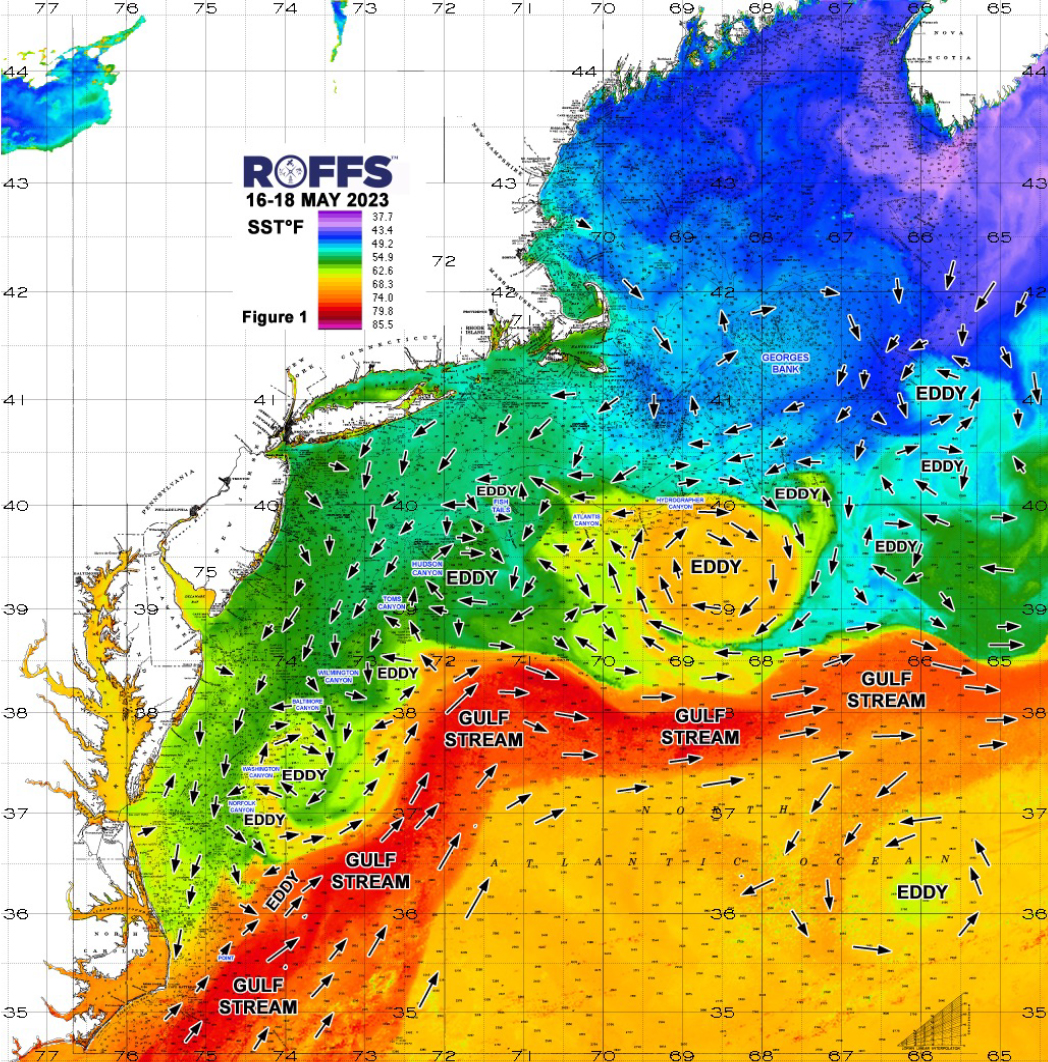
Figure 1: This year’s Northeast U.S. conditions were derived from a variety of infrared sensors to get SST from NASA, NOAA and ESA satellites during May 16-18, 2023. Main eddy features, canyons and surface currents are labeled.
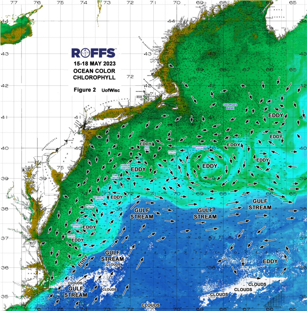
Figure 2: This year’s Northeast U.S. conditions derived from the ocean color/chlorophyll imagery during May 15-18, 2023 from the Aqua and Terra sensors on the MODIS satellite and SNPP and NOAA 20 VIIRS provided by the University of Wisconsin and from Sentinel 3A & 3B ESA satellite data. We consider this an image pair with the above SST Figure 1 image. Same main eddy features and surface currents labeled.
It is also important to look further east for eddies and conditions forming east of Oceanographer Canyon and south to southeast Georges Bank. As these will likely be the features that contribute and progress west then southwest and is what anglers will be targeting during mid-to-late summer season and bigger tournament season from over the canyons south of New York then to the canyons offshore of New Jersey, Delaware, Maryland and Virginia. At this time, there are a few eddies farther east to keep track of that could be promising as they move west during the next couple of months, but they are still cool and too far north of the Gulf Stream to get a good read on them and to have much of an impact on the canyon regions at this time.
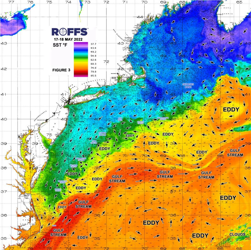
Figure 3. Last year’s Northeast U.S. conditions were derived from a variety of infrared sensors to get SST from NASA, NOAA and ESA satellites during May 17-18, 2022. Main eddy features, canyons and surface currents are labeled.
Looking at Figure 2, notice the lack of bluer water to the north and west over this region (especially inshore out to 50-100 fathoms) at this time because we are at the peak season of the spring algae bloom. This is an annual spring event that provides the food and the beginning of the life cycle for many of the plankton and baitfish species for the next month or two. However, just because the surface water is greener in color within these offshore eddies, a few feet below the surface the water is likely clearer and bluer. IN FACT, what we already notice is overall for this time of year, the water offshore of 100 fathoms near the canyons is cleaner, blended blue to blue-green, in many locations within the eddy systems and closer to the bank and canyons. This lines up with our theory that this year the water looks better and more favorable in many locations for earlier and higher abundance of target fish species compared to the previous two years. The ocean color/chlorophyll signature becomes much more important later in the summer to distinguish the main water mass boundaries and features when the SST is more warm and uniform.
Another indicator of this year’s spring to early summer fishing season is the orientation of the Gulf Stream. If you look at the location of the Gulf Stream in comparison to last year’s SST conditions (Figure 3) and compare it to this year’s conditions (Figure 1), you can see the Gulf Stream this year appears to be farther north especially when you get west of 70°00’W than last year, indicating a closer source of fish closer to the western canyons this year than last year. Also, overall the water between 500/1000 fathoms and the Gulf Stream are cooler than last year, but the Gulf Stream is closer to most of the Canyon regions. This means it is only a matter of time when the atmospheric temperature warms the water rapidly and provides a pathway for the larger population of fish from offshore to the canyon regions and further inshore.
Other evidence for forecasting the 2023 season is the recent fishing reports. If this season is any indication of the positive reports and good ocean conditions we have had so far, it may be a GREAT late spring and summer fishing season in the northeast canyon regions. There have been multiple reports of bluefin tuna being in high numbers along the bank from Hudson Canyon and southwest this later winter and spring. In fact, there have been nice bluefin reports directly off of New Jersey this past week or two in 10-15 fathoms in places. There has been a good blue marlin and mahi bite already off of North Carolina, but a slower than normal start for tuna off of North Carolina. Furthermore, there have been multiple reports of yellowfin, mahi and even bigeye tuna in the warmer eddy water off of Wilmington to Baltimore, Poor Mans and Washington Canyon. These are all promising signs and support for an early start to the fishing season in the Northeast and a good indicator of a productive fishing season that should be better than last year (at least in May, June and into July). Also, not many have fished it yet, but there have been some bluefin tuna and yellowfin tuna caught in that larger Gulf Stream Warm Core eddy water off of Veatch to Hydrographer Canyons and there must be some mahi and swordfish in there also.
Conclusion
Based on what we have been observing over the last few weeks, it appears that the arrival of the larger populations of tuna, wahoo, mahi-mahi, and billfish may arrive at a normal to earlier time this year compared to the past 2-3 years as the overall SST is warmer in many areas and there are more promising warm-core Gulf Stream eddies and features in this region that are closer to the canyons compared to the past few years. Again, it remains to be seen how many bigeye will arrive this year, as this is still a mystery over the last few years, but there already been some reports of bigeye tuna in the canyon regions. Bigeye tuna tend to stay deeper in water column, prefer slightly cooler water than yellowfin and are many times associated with pilot wales and come into the canyon areas early in the morning or early evening to feed then go back offshore. Yellowfin tuna is another mystery most years, as usually the best yellowfin action is during late May and June then becomes scattered and then picks up to be better again in September to early October. However, last year tuna was pretty steady most of the summer.
The BEST NEWS is that overall we are very encouraged of how the ocean conditions look this year and what it means for a productive successful fishing season this summer. The conditions look better this time of year than the previous 2-3 years, which should indicate and earlier start of the season (it has started already in some canyon regions). The promising warm core Gulf Stream eddies out east indicate these good conditions should last a few more months into the meat of the summer fun fishing and tournament season for the western canyons. Last year was a different year as the white marlin and mahi population was well below normal in the areas offshore of North Carolina to New Jersey and parts of New York and the better fishing conditions and overall populations of target species were out east offshore of eastern New York to Massachusetts. Therefore, It is exciting to report that we think the conditions overall from all canyons should be overall better than last year based on how the ocean conditions look right now.
We highly encourage you to take a look at these early season conditions and if you have not done so already, get your boat ready and get offshore when the weather permits, as there are some tuna and mahi action to be had in some of the canyon regions already and even marlin down off of North Carolina. The bottom line is conditions look BETTER overall this year in mid-to-late May than the past 2-3 years, so you should be ready to fish the canyon regions (and inshore) now and certainly by June, especially off of Massachusetts and Rhode Island where the conditions are good NOW and improving most everywhere else.
It is important to remember that good fishing action on a daily basis is strongly linked to local, short-term (days) current conditions that concentrate the fish once the preferred habitats of the fish are in a particular region. When the water mass boundaries associated with these currents are geographically stable and favorable, i.e., persistently pushing over “good” bottom topography and/or in a favorable inshore direction creating upwelling, then they concentrate the baitfish and larger fish can be found foraging. This indicates that the fishing action on any given day is controlled by relatively short-term (hourly to daily) and relatively small-scale (5-10 mile) movements of the currents and their water mass boundaries. Our experience indicates that to reliably forecast specific concentrations of fish on a daily basis one must evaluate the ocean conditions on these scales. Relatively small, subtle changes in the currents and their associated water mass boundary zones often have dramatic effects on the distribution and concentration of fish.
Contact ROFFS™ (1-321-723-5759 / fishing@roffs.com / www.roffs.com, @roffsfishing on Facebook and Instagram) for the up-to-date detailed fishing conditions and get the inside track to where the better fishing locations will be tomorrow. Our experienced satellite and fishery oceanographers will continue to monitor the northeast U.S. oceanographic conditions closely as the season quickly improves and the active summer fun fishing and tournament season rapidly approaches. Thank you for your support.
Best of Luck for a Safe and Successful Fishing Season,
ROFFS™ Team